
 United Kingdom
 France
 Germany
 Netherlands
 Sweden
 USA
USA
 Italy
Italy
 Spain
Spain
More From Contributor


Brighton And Lewes WATERPROOF
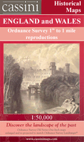
Map No. 198, Brighton and Lewes, in a waterproof and tear-resistant version of the Ordnance Survey Landranger series at 1:50, 000, including Worthing, Horsham, Haywards Heath, Crawley, Burgess Hill, Uckfield, Newhaven, Seaford, Shoreham-by-Sea, Turners Hill, Forest Row, Sinfold, Balcombe, Sharpthorne, Nutley, Ardingly, Handcross, Slinfold, Southwater, Broadford Bridge, Cowfold, Partridge Green, Hurstpierpoint, South Chailey, Ashington, Henfield, Clayton, Ringmer, Glyndebourne, Woodingdean, Stayning, Findon, and part of the Low Weald. Edition E2; Revised 2001; Revised for selected changes 2002, 2008; Copyright date 2009 This title is also available on our website in a paper version.Maps in this series are only published folded. Stanfords can also print
flat versions of Ordnance Survey maps through the OS Select system, centring the map on a location of your choice and with a picture provided by you on the cover. For more information please click on the link at the bottom of this description.About Ordnance Survey
flat versions of Ordnance Survey maps through the OS Select system, centring the map on a location of your choice and with a picture provided by you on the cover. For more information please click on the link at the bottom of this description.About Ordnance Survey
Product Description
Reviews/Comments
Add New
Intelligent Comparison
Archived Product
Brighton And Lewes Stanfords
£5.59
Archived Product
Bristol And Bath WATERPROOF Stanfords
£10.39
Archived Product
Swindon And Devizes WATERPROOF Stanfords
£10.39
Archived Product
Taunton And Lyme Regis WATERPROOF Stanfords
£10.39
Archived Product
Brighton And Lewes 1920 Stanfords
£9.99
Archived Product
Brighton And Lewes 1898 Stanfords
£7.99
Archived Product

Brighton And Lewes OS ACTIVE Map Stanfords
£9.09
Archived Product
St Andrews WATERPROOF Stanfords
£10.39
Vouchers
No voucher codes found.
Do you know a voucher code for this product or supplier? Add it to Insights for others to use.
Do you know a voucher code for this product or supplier? Add it to Insights for others to use.
 Denmark