
 United Kingdom
 France
 Germany
 Netherlands
 Sweden
 USA
USA
 Italy
Italy
 Spain
Spain
More From Contributor


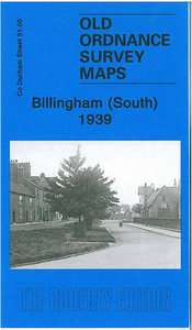
Billingham South 1939
Billingham South in 1939 in a fascinating series of reproductions of old Ordnance Survey plans in the Alan Godfrey Editions, ideal for anyone interested in the history of their neighbourhood or family. The map covers the old village of Billingham, with St Cuthbert`s church and The Green in the top left corner. Coverage then extends south to the Billingham Beck and east to Haverton Hill Road and the Billingham Beck railway line. However, much of the map is taken up with the extraordinary industrial complex of ICI - Imperial Chemical Industries - which ran east from Chiltons Avenue. Billingham by 1939 was very much a company town. Also included is a historical introduction to Billingham from a 1894 map and a directory of the town in 1934.About the Alan Godfrey Editions of the 25” OS
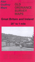
Series:Selected towns in Great Britain and Ireland are covered by maps showing the extent of urban development in the last decades of the 19th and early 20th century. The plans have been taken from the Ordnance Survey mapping and reprinted at about 15 inches to one mile (1:4, 340). On the reverse most maps have historical notes and many also include extracts from contemporary directories. Most maps cover about one mile (1.6kms) north/south, one and a half miles (2.4kms) across; adjoining sheets can be combined to provide wider coverage.FOR MORE INFORMATION AND A COMPLETE LIST OF ALL AVAILABLE TITLES PLEASE CLICK ON THE SERIES LINK.
Series:Selected towns in Great Britain and Ireland are covered by maps showing the extent of urban development in the last decades of the 19th and early 20th century. The plans have been taken from the Ordnance Survey mapping and reprinted at about 15 inches to one mile (1:4, 340). On the reverse most maps have historical notes and many also include extracts from contemporary directories. Most maps cover about one mile (1.6kms) north/south, one and a half miles (2.4kms) across; adjoining sheets can be combined to provide wider coverage.FOR MORE INFORMATION AND A COMPLETE LIST OF ALL AVAILABLE TITLES PLEASE CLICK ON THE SERIES LINK.

Product Description
Reviews/Comments
Add New
Intelligent Comparison
Archived Product

Birmingham South 1913 Stanfords
£3.50
Archived Product
Birmingham North 1913 Stanfords
£3.50
Archived Product

Nottingham South 1899 Stanfords
£3.50
Archived Product
Hillingdon South 1935 Stanfords
£3.50
Archived Product
Birmingham South 1888 Stanfords
£2.95
Archived Product

Birmingham South 1888 Stanfords
£3.50
Vouchers
No voucher codes found.
Do you know a voucher code for this product or supplier? Add it to Insights for others to use.
Do you know a voucher code for this product or supplier? Add it to Insights for others to use.
 Denmark