More From Contributor
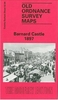
£3.50
Barking & Upney in 1897 in a fascinating series of reproductions of old Ordnance Survey plans in the Alan Godfrey Editions, ideal for anyone interested in the history of their neighbourhood or family. Three versions have been published for this area. The maps cover the eastern side of Barking but they are from different series, the ` Old` (map no. 74.09) & ` New` (maps no. 68.04) Essex Series, so the sheetlines are somewhat different. The ` New` Series maps link up more conveniently with the London Series. The Barking & Upney 1897 (No. 74.09) map is on different sheetlines than the other two versions, showing much the same area but stretching somewhat further west & south. This means that it does cover part of central Barking, including the station, Local Board Offices on East Street, Ripple Road, St Paul`s Road & southward to Morley Road. Along the southern part of the map are Greatfield, Mowers House, Eastbury House & the cemetery. The village of Upney is top centre. The map

Includes::
a commercial directory for Barking 1894. The Upney 1915 (No. 86.04a) map captures the eastern side of Barking showing the streets off Longbridge Road gradually being built up: Cecil Avenue, Wilmington Gardens, Hulse Avenue etc. North of this is Barking Park. From here coverage extends a mile eastward into open country. The hamlet of Upney is bottom centre, with its Isolation Hospital, Manor Farm is to the north-east. The LTS railway crosses the map west-east but no stations are shown. A directory listing of private residents in Barking in 1895 & 1920 is included. The Upney 1939 (No. 86.04b) map provides a strong contrast, for the area is now largely built up, with many roads now developed off Longbridge Road. Upney station is now open, & other features include Lodge Avenue & streets to its east, Sandringham Road, Barking Park, isolation hospital (no longer very isolated!) Extracts from a 1933 directory are included. About the Alan Godfrey Editions of the 25” OS Series: Selected towns in Great Britain & Ireland are covered by maps showing the extent of urban development in the last decades of the 19th & early 20th century. The plans have been taken from the Ordnance Survey mapping & reprinted at about 15 inches to one mile (1:4, 340). On the reverse most maps have historical notes & many also include extracts from contemporary directories. Most maps cover about one mile (1.6kms) north/south, one & a half miles (2.4kms) across; adjoining sheets can be combined to provide wider coverage.FOR MORE INFORMATION & A COMPLETE LIST OF ALL AVAILABLE TITLES PLEASE CLICK ON THE SERIES LINK.

...
Archived Product
£15.95
The abbey at Barking was used as residence by William the Conqueror while the Tower of London was built. Its remains may still be seen near the old town quay. Barking had the largest fishing fleet in the world, the town thriving on its trade. As railways transported fish to London direct from east coast ports, this trade declined, but Barking`s riverside encouraged heavy industry. The town`s population increased enormously when the LCC built the massive Becontree estate to house London families from the East End. ...
Archived Product
£6.99
Sally loves nothing more than investigating a good mystery
- & her shaggy French poodle Fetch loves nothing more than to be at
...
Archived Product
£9.99
From Annie Proulx, the Pulitzer Prize-winning author of The Shipping News & Brokeback Mountain, comes her masterwork: an epic, dazzling, violent, magnificently dramatic novel about the taking down of the world`s forests. In the late seventeenth century two penniless young Frenchmen, Rene Sel & Charles Duquet, arrive in New France. Bound to a feudal lord, a ”seigneur, ” for three years in exchange for l&, they become wood-cutters
- barkskins. Rene suffers extraordinary hardship, oppressed by the forest he is charged with clearing. He is forced to marry a Mi`kmaw woman & their descendants live trapped between two inimical cultures. But Duquet, crafty & ruthless, runs away from the seigneur, becomes a fur trader, then sets up a timber business. Proulx tells the stories of the descendants of Sel & Duquet over three hundred years
- their travels across North America, to Europe, China, & New Zeal&, under stunningly brutal conditions; the revenge of rivals; accidents; pestilence; Indian attacks; & cultural annihilation. Over & over again, they seize what they can of a presumed infinite resource, leaving the modern-day characters face to face with possible ecological collapse. Proulx`s inimitable genius is her creation of characters who are so vivid
- in their greed, lust, vengefulness, or their simple compassion & hope
- that we follow them with fierce attention. Annie Proulx is one of the most formidable & compelling American writers, & Barkskins is her greatest novel, a magnificent marriage of history & imagination.


...
Archived Product
£2.95
Barlow Moor & West Didsbury in 1905 in a fascinating series of reproductions of old Ordnance Survey plans in the Alan Godfrey Editions, ideal for anyone interested in the history of their neighbourhood or family. Selected towns in Great Britain & Ireland are covered by maps showing the extent of urban development in the last decades of the 19th & early 20th century. In this title: the map covers West Didsbury & the area northward across Barlow Moor to Houghend Hall. Manchester Southern Cemetery is a major feature. The Midland Railway runs across the map, & Withington & Albert Park station is near the south-eastern corner. Other features include Barlow Hall, Barlow Hall Farm, Christ Church, Chorlton Union Workhouse, St Luke's church, Albert Park, fever hospital, Pinfold Farm, Barlow Moor Road, Manchester Crematorium, etc. On the reverse is a selection of street directory entries, including Barlow Moor Road. About the Alan Godfrey Editions of the 25 ...
Archived Product
£12.99
The sight of a ghostly Barn Owl quartering a field at dusk is not one that is easily forgotten, but the day-to-day lives of these captivating birds are little known to most people. In this book, insightful text coupled with rarely seen images of the species` life & behaviour introduces the reader to some of the most fascinating aspects of a remarkable nocturnal existence. There are chapters on subjects such as hunting, courtship & survival. The owls are further brought to life through a series of personal anecdotes from the author & photographer, which are woven into the text. The book is part of a series that also

Includes::
titles on the Kingfisher & Peregrine Falcon. Birdwatchers
- there are more than 1 million RSPB members in the UK & the pastime is growing in popularity in many countries around the world. It will have strong appeal to a wide readership encompassing general nature enthusiasts.


...
Archived Product
£10.00
Renowned nature writer Jim Crumley gets up close & personal with some of Britain`s most iconic & loved animals
- here, the barn
...
Archived Product
£8.99
The OS Landranger Map series covers Great Britain with 204 detailed maps, perfect for day trips & short breaks. Each map provides all the information you need to get to know your local area &

Includes::
places of interest, tourist information, picnic areas & camp sites, plus Rights of Way information for England & Wales. OS Landranger now

Includes::
a digital version of the paper map, accessed through the OS smartphone app, OS Maps.


...
Archived Product
£14.99
Waterproof & tear-resistant OS Active version of map No. 92 from the Ordnance Survey’s Landranger series at 1:50, 000, with contoured & GPS compatible topographic mapping plus tourist information.MOBILE DOWNLOADS: As well as the physical edition of the map, each Landranger title now

Includes::
a code for downloading after purchase its digital version onto your smartphone or tablet for viewing on the OS smartphone app.OS LANDRANGER SERIES: to see the list of all the titles in the OS Landranger series, both paper & waterproof versions, please click on the series link. Maps in the Landranger series provide plenty of recreational & tourist information, indicating the traditional public right of way paths (except in Scotland where different laws apply), including bridleways & byways restricted or open to motorized traffic. National Trails & selected other long-distance paths are marked, as well as on-road & traffic-free cycle routes with their National/ Regional Cycle Network numbers. National Trust/ National Trust for Scotland & Forestry Commission land is clearly marked, indicating open or restricted access. A range of symbols highlights camping & caravanning sites, youth hostels, tourist information offices & visitors’ centres, parking & picnicking places, World Heritage sites, sport & recreational facilities, etc. The maps provide detailed presentation of topography with contours at 10m intervals, numerous spot heights & additional colouring and/or graphics for different types of woodlands, orchards or parkl&, rock features including scree & cliffs, water features inland & along the sea shore with marshl&, dunes, s&, mud, shingle & the high water mark. All the standard information expected of survey mapping at this scale is included: finely graded road network, railway lines with stations, cuttings, embankments, etc; individual isolated buildings; archaeological & historical sites, etc. For GPS users the British National Grid is shown at 1km intervals, with latitude & longitude given by margin ticks at 1` & cross hairs on the map at 5`. Each map covers an area of 40 x 40km, (approx. 25 x 25 miles).

...
Archived Product
£3.50
Barnard Castle in 1897 in a fascinating series of reproductions of old Ordnance Survey plans in the Alan Godfrey Editions, ideal for anyone interested in the history of their neighbourhood or family. Most of the town is covered & features include The Bank, Market Place, Horse Market, Galgate, Station Road with NER goods station (but not passenger station), Castle, St Mary`s church, Cattle Market, Wool House, Teesdale Workhouse, Bowes Museum, North Eastern County School, etc. The small area of Yorkshire across the River Tees

Includes::
Bridge End, Low Startforth, High Startforth & Holy Trinity church. A directory of private residents is on the reverse. About the Alan Godfrey Editions of the 25” OS Series: Selected towns in Great Britain & Ireland are covered by maps showing the extent of urban development in the last decades of the 19th & early 20th century. The plans have been taken from the Ordnance Survey mapping & reprinted at about 15 inches to one mile (1:4, 340). On the reverse most maps have historical notes & many also include extracts from contemporary directories. Most maps cover about one mile (1.6kms) north/south, one & a half miles (2.4kms) across; adjoining sheets can be combined to provide wider coverage.FOR MORE INFORMATION & A COMPLETE LIST OF ALL AVAILABLE TITLES PLEASE CLICK ON THE SERIES LINK.

...
Archived Product

Barmouth 1900

Barmouth in 1900 in a fascinating series of reproductions of old Ordnance Survey plans in the Alan Godfrey Editions, ideal for anyone interested in the history of their neighbourhood or family. Points of interest include St Margarets School, St Tudwals RC Church, Orielton Hall and St Johns Church, Orielton Wood, Barmouth Bridge, Aber-Amffra Harbour and the Cambrian Railway. On the reverse is a map of the area to the north of Barmouth, including Parsel.About the Alan Godfrey Editions of the 25” OS Series:Selected towns in Great Britain and Ireland are covered by maps showing the extent of urban development in the last decades of the 19th and early 20th century. The plans have been taken from the Ordnance Survey mapping and reprinted at about 15 inches to one mile (1:4, 340). On the
reverse most maps have historical notes and many also include extracts from contemporary directories. Most maps cover about one mile (1.6kms) north/south, one and a half miles (2.4kms) across; adjoining sheets can be combined to provide wider coverage.FOR MORE INFORMATION AND A COMPLETE LIST OF ALL AVAILABLE TITLES PLEASE CLICK ON THE SERIES LINK.
RIP - This product is no longer available on our network. It was last seen on 25.09.2019

This page now acts as a permanent archive for this product. Add more information using the comments box below to ensure it can still be found by future generations.

Use our search facility to see if it is available from an alternative contributor.
  • External links may include paid for promotion
  • Availability: Out Of Stock
  • Supplier: Stanfords
  • SKU: 9781841516448
Availability: In Stock
£3.50

Product Description

Barmouth in 1900 in a fascinating series of reproductions of old Ordnance Survey plans in the Alan Godfrey Editions, ideal for anyone interested in the history of their neighbourhood or family. Points of interest include St Margarets School, St Tudwals RC Church, Orielton Hall & St Johns Church, Orielton Wood, Barmouth Bridge, Aber-Amffra Harbour & the Cambrian Railway. On the reverse is a map of the area to the north of Barmouth, including Parsel. About the Alan Godfrey Editions of the 25” OS Series: Selected towns in Great Britain & Ireland are covered by maps showing the extent of urban development in the last decades of the 19th & early 20th century. The plans have been taken from the Ordnance Survey mapping & reprinted at about 15 inches to one mile (1:4, 340). On the reverse most maps have historical notes & many also include extracts from contemporary directories. Most maps cover about one mile (1.6kms) north/south, one & a half miles (2.4kms) across; adjoining sheets can be combined to provide wider coverage.FOR MORE INFORMATION & A COMPLETE LIST OF ALL AVAILABLE TITLES PLEASE CLICK ON THE SERIES LINK.

Reviews/Comments

Add New

Price History

Vouchers

No voucher codes found.
Do you know a voucher code for this product or supplier? Add it to Insights for others to use.

Facebook

Jargon Buster

Contemporary - Modern era design
Contemporary - A design reference to indicate post war modern design
History - Anything that happens in the past. An acedemic subject.
Wood - A hard material found in trees. Used for tool making, fuel and construction.
Contemporary - An object that is living in the same time.
Hall - A room at the inside of an entrance of a house.
Ideal - Something that satisfies a perfect criteria.
Family - A group of people that live together made up from parents and children.

Supplier Information

Stanfords
Stanfords was established in 1853 and opened their iconic Covent Garden flagship store in 1901. They have become the top retailer of maps, travel books and accessories in the UK and arguably offer the largest selection of maps and travel books worldwide. Famous names such as Captain Robert Falcon Scott, Ranulph Fiennes and Michael Palin have purchased from Stanfords. They now have a shop in Bristol and both stores together with other venues operate a calendar of events including talks, book signings and exhibitions. As a specialist map retailer, the map selection is comprehensive and includes road maps, street maps and walking maps from worldwide destinations, as well as a selection of world atlases and wall maps. Books include travel guides and travel literature. Stanfords also stock globes, from miniatures made of blue marble to magnificent floor-standing globes. The website features a selection of interesting articles on travel topics.
Page Updated: 2023-11-12 20:15:36

Community Generated Product Tags

Oh No! The productWIKI community hasn't generated any tags for this product yet!
Menu