
 United Kingdom
 France
 Germany
 Netherlands
 Sweden
 USA
USA
 Italy
Italy
 Spain
Spain
More From Contributor


Barcelona F&B
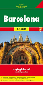
Large map covering most of the city - from Badalona in the northeast to Port Vell and la Mogoria la Franca in the south and Tibidabo in the west.Road detail is clear and main roads are in bold colours. Pedestrian zones are marked, also railways, metro lines, cable cars, public buildings, industrial zones, parks, cemeteries and sports grounds. Symbols depict places of worship, car parks, tourist information offices, post offices, hospitals, police stations, monuments, UNESCO sites, theatres, museums.An inset road map shows the main roads in the surrounding region.Multilingual legend includes English. Street index on reverse.

Product Description
Reviews/Comments
Add New
Intelligent Comparison
Archived Product
Barcelona Stanfords
£8.95
Archived Product
Barcelona Stanfords
£4.99
Archived Product
Barcelona Stanfords
£7.95
Archived Product
Barcelona Stanfords
£32.95
Archived Product
Barcelona Stanfords
£4.99
Archived Product
Barcelona Stanfords
£10.39
Archived Product
Barcelona Stanfords
£3.99
Archived Product
Barcelona Stanfords
£12.99
Vouchers
No voucher codes found.
Do you know a voucher code for this product or supplier? Add it to Insights for others to use.
Do you know a voucher code for this product or supplier? Add it to Insights for others to use.
 Denmark