
 United Kingdom
 France
 Germany
 Netherlands
 Sweden
 USA
USA
 Italy
Italy
 Spain
Spain
More From Contributor


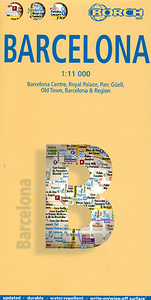
Barcelona Borch
Barcelona on a laminated and waterproof tourist street plan from Borch, combining a plan of the city with an enlargement for the Old Town, a diagram of the metro/tram network, a map of the environs with access to the airport, etc.The main plan at 1:11, 000 extends north-west to just beyond Barcelona’s Nou Camp football stadium, with two areas further north, Palau Reial university campus and Parc Güell, shown as insets.On the reverse an enlargement at 1:5, 500 presents the Old Town in much greater detail. Both plans show metro stations, one way or pedestrianized streets and car parks. Numerous places of interest, including selected hotels, museums and other cultural institutions, etc, are named, with Top 30 of the city’s main sights prominently highlighted on the plans.
Both plans are indexed, with separate lists of streets, public buildings/places of interest, selected hotels and embassies, markets/department stores, etc. Map legend includes English.Also included is a diagram of Barcelona’s metro/tram network (good eyesight for reading small print is required!), and a map of the city’s environs at 1:150, 000 showing access to the airport. The map also provides monthly graphs of the city’s climate and a small administrative map of Spain
Both plans are indexed, with separate lists of streets, public buildings/places of interest, selected hotels and embassies, markets/department stores, etc. Map legend includes English.Also included is a diagram of Barcelona’s metro/tram network (good eyesight for reading small print is required!), and a map of the city’s environs at 1:150, 000 showing access to the airport. The map also provides monthly graphs of the city’s climate and a small administrative map of Spain

Product Description
Reviews/Comments
Add New
Intelligent Comparison
Archived Product
Barcelona Noir Stanfords
£12.99
Archived Product
Barcelona F&B Stanfords
£9.99
Archived Product
Barcelona Stanfords
£4.99
Archived Product
Barcelona Stanfords
£7.95
Archived Product
Barcelona Stanfords
£32.95
Archived Product
Barcelona Stanfords
£4.99
Archived Product
Barcelona Stanfords
£10.39
Archived Product
Barcelona Stanfords
£3.99
Vouchers
No voucher codes found.
Do you know a voucher code for this product or supplier? Add it to Insights for others to use.
Do you know a voucher code for this product or supplier? Add it to Insights for others to use.
 Denmark