More From Contributor

£30.00
Located at the intersection of Asia & the Middle East, Afghanistan has been strategically important for thousands of years. Its ancient trade routes & strategic position between India, Inner Asia, China, Persia & beyond has meant the region has been subject to frequent invasions. Modern Afghanistan is a culturally & ethnically diverse country, but one divided by conflict, political instability & by mass displacements of its people. Jonathan L. Lee places the current conflict in Afghanistan in its historical context & challenges many of the West`s preconceived ideas about the country. Lee chronicles the region`s monarchic rules & the Durrani dynasty, focusing on the reigns of each ruler & their efforts to balance tribal, ethnic, regional & religious factions, moving on to the struggle for social & constitutional reform & the rise of Islamic & Communist factions. He offers new cultural & political insights from Persian histories, the memoirs of Afghan government officials, British government & India Office archives, recently released cia reports & Wiki Leaks documents. Lee also sheds new light on the country`s foreign relations, its internal power struggles & the impact of foreign military interventions such as the ` War on Terror`. ...
Archived Product
£7.99
Mackinac Island is on the Great Lakes in the American Midwest. Just nine miles round, it has golf courses, expensive restaurants, no cars & plenty of rich people. & for the summer of 2000, it has Bell, a student, employed to serve the wealthy. Bell & her fellow waiters & waitresses sample the delights of this earthly paradise: luxurious yachts, alcohol, horse-drawn carriages; & they can't help but come to know each other intimately. But this knowledge comes at a price. For they have each carried with them secrets from the outside world that will not be left behind... This is a superb debut which offers an exquisitely distilled exploration of North American material & spiritual values
- & equally
- a riveting story of love, betrayal & survival.

...
Archived Product
£7.99
Afoot in England looks at the life of Argentinean born William Henry Hudson following his settlement in England in 1869. Hudson began a new life as a wanderer & field naturalist & his country rambles were an escape from a life that then held few other pleasures, not least many years living in poverty in London. The books he wrote about the English countryside eventually brought him fame &, in turn, helped him foster the back-to-nature movement of the 1920s & 1930s. Afoot in England recounts Hudson ...
Archived Product
£8.99
Afoot in England looks at the life of Argentinean born William Henry Hudson following his settlement in England in 1869. Hudson began a new life as a wanderer & field naturalist & his country rambles were an escape from a life that then held few other pleasures, not least many years living in poverty in London. The books he wrote about the English countryside eventually brought him fame &, in turn, helped him foster the back-to-nature movement of the 1920s & 1930s. Afoot in England recounts Hudson’s wanderings from village to village across the south of Engl&, from Surrey to Devon & Cornwall, & along the East Anglian coast. It speaks as powerfully today of the simple pleasures of the English countryside as when it was first published in 1909. The book is introduced by modern day naturalist Robert Macfarlane. About this series: Stanfords Travel Classics feature some of the finest historical travel writing in the English language, with authors hailing from both sides of the Atlantic. Every title has been reset in a contemporary typeface to create a series that every lover of fine travel literature will want to collect & keep. ...
Archived Product
£4.99
A double sided map of Africa to the scale of 1:11, 500, 000. One side of the map is Africa-Political, the other Africa-Physical. Both sides of the map also show areas of the Middle East & southern Europe which border on the continent & have enlarged box insets, for the purposes of geographical positioning only, of non African islands such as Mauritius, Cape Verde, Seychelles & The Azores. The Africa-Political map shows lines of latitude & longitude, displays national flags along its top & details basic information about each country ...
Archived Product
£10.50
Putumayo's Africa seeks to inspire the listener to further explore the richness & variety of African music. One cannot overstate the influence Africa has had on music of the world. Jazz, blues, rock & roll, gospel, salsa, samba, funk, hip-hop, reggae, zydeco, zouk
- the list of genres which have roots in African music is endless. Africa is home to a myriad of styles, & it remains one of the most creative places for music on the planet.CD Track listing: 1 Oliver Mtukudzi, ' Ndima Ndapedza' (Zimbabwe) 2 Soul Brothers, ' Thandaza' (South Africa) 3 Afia Mala, ' Segne' (Togo) 4 Johnny Clegg & Juluka, ' Love is Just a Dream' (South Africa) 5 4 Etoiles, ' Doly' (Congo) 6 Samba Ngo, ' Sa Ntima' (Congo) 7 Habib Koit
...
Archived Product
£7.50
Brightly & attractively coloured political map, with internal administrative divisions of each country also indicated by colours. Names of administrative provinces & of provincial capitals are shown in some, but not all of the countries. Towns are graded by populations, although the map shows, with some exceptions, relatively few place names. There is some indication of the continents topography with spot heights & names of main mountain ranges, peaks, & deserts. All names, including those of the countries, are in French, as is the map's legend. Coverage

Includes::
both Cape Verde & the Azores, & extends, without any colouring, to the whole of the Mediterranean basin, the Black Sea, the Caspian Sea, the Arabian Peninsula & most of Iran. Latitude & longitude lines are marked at 10

...
Archived Product
£13.50
A small political map of the continent showing the different countries in restrained colours against the dark blue sea. Coverage extends to include the whole of the Mediterranean, the Black Sea, the Caspian Sea, the Arabian Peninsula, & virtually all of Iran, but without Cape Verde Islands. Countries, with their names in English, are shown with internal administrative divisions, the state & provincial capitals are highlighted, & symbols for towns & cities indicate their approximate population. Communications network

Includes::
main roads, railways, airports, with rivers shown indicating their navigable parts. Salt pans, wadis, waterfalls & rapids, are also marked, as well as national parks & oases. Names of some of the geographical features such as deserts & mountain ranges are given, plus spot heights. Latitude & longitude lines are drawn at 5

...
Archived Product
£10.50
Putumayo's Africa seeks to inspire the listener to further explore the richness & variety of African music. One cannot overstate the influence Africa has had on music of the world. Jazz, blues, rock & roll, gospel, salsa, samba, funk, hip-hop, reggae, zydeco, zouk
- the list of genres which have roots in African music is endless. Africa is home to a myriad of styles, & it remains one of the most creative places for music on the planet.CD Track listing: 1 Oliver Mtukudzi, ' Ndima Ndapedza' (Zimbabwe) 2 Soul Brothers, ' Thandaza' (South Africa) 3 Afia Mala, ' Segne' (Togo) 4 Johnny Clegg & Juluka, ' Love is Just a Dream' (South Africa) 5 4 Etoiles, ' Doly' (Congo) 6 Samba Ngo, ' Sa Ntima' (Congo) 7 Habib Koit
...
Archived Product
£18.39
Africa in the Countries & Regions series from Lonely Planet, market-leading comprehensive guides aimed at independent travellers & serving a large range of international destinations. Frank & informal in style, the guides explore an extensive range of sights, activities, accommodation, restaurants & nightlife & are designed for practical use while travelling on the road. Written & researched by a team of experts, each book is independent in its recommendations & suggestions, often offering individual takes on individual destinations. Widely recognised for their reliability, each Lonely Planet country & region guide has the same layout. Introductory sections profile the destination with individual chapters on particular highlights, getting started, (including when to go) itineraries, history, culture, arts, food & drink & the environment. Each guide is organised geographically by region, with individual sections detailing an extensive range of sights, places of interest, attractions, restaurants, nightlife, accommodation & any local activities. The guides have detailed explanations of historical context where relevant. There is also practical guidance on ...
Archived Product

Africa

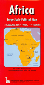
Political map of Africa and the neighbouring regions, including the Mediterranean basin but without northern Adriatic, and the most of the Middle East except for the eastern part of the Arabian Peninsula. Cape Verde Islands are shown as an inset. Countries are shown in bright colours with their borders enhanced by darker colouring. Some countries also include internal administrative boundaries. Road and rail networks are shown, plus in countries such as Algeria and Libya main oils fields and pipelines. The map shows a lot of towns and names of geographical features such as mountain and deserts, but the overall presentation is rather old fashioned and cluttered. Latitude and longitude lines are drawn at 10° intervals. Also included is a large inset showing the continent with bright
elevation colouring and names of principal deserts and mountain ranges. Along the bottom of the map are flags of all the countries.
RIP - This product is no longer available on our network. It was last seen on 25.09.2019

This page now acts as a permanent archive for this product. Add more information using the comments box below to ensure it can still be found by future generations.

Use our search facility to see if it is available from an alternative contributor.
  • External links may include paid for promotion
  • Availability: Out Of Stock
  • Supplier: Stanfords
  • SKU: 9781858793757
Availability: In Stock
£8.95

Product Description

Political map of Africa & the neighbouring regions, including the Mediterranean basin but without northern Adriatic, & the most of the Middle East except for the eastern part of the Arabian Peninsula. Cape Verde Islands are shown as an inset. Countries are shown in bright colours with their borders enhanced by darker colouring. Some countries also include internal administrative boundaries. Road & rail networks are shown, plus in countries such as Algeria & Libya main oils fields & pipelines. The map shows a lot of towns & names of geographical features such as mountain & deserts, but the overall presentation is rather old fashioned & cluttered. Latitude & longitude lines are drawn at 10° intervals. Also included is a large inset showing the continent with bright elevation colouring & names of principal deserts & mountain ranges. Along the bottom of the map are flags of all the countries.

Reviews/Comments

Add New

Price History

Vouchers

No voucher codes found.
Do you know a voucher code for this product or supplier? Add it to Insights for others to use.

Facebook

Jargon Buster

Large - something that takes up more space than normal.
Road - a manmade lane or a path that is used to speed up travel.
Borders - A line that sometimes can be built up separating off an area, e.g. countries "the welsh boarder"

Supplier Information

Stanfords
Stanfords was established in 1853 and opened their iconic Covent Garden flagship store in 1901. They have become the top retailer of maps, travel books and accessories in the UK and arguably offer the largest selection of maps and travel books worldwide. Famous names such as Captain Robert Falcon Scott, Ranulph Fiennes and Michael Palin have purchased from Stanfords. They now have a shop in Bristol and both stores together with other venues operate a calendar of events including talks, book signings and exhibitions. As a specialist map retailer, the map selection is comprehensive and includes road maps, street maps and walking maps from worldwide destinations, as well as a selection of world atlases and wall maps. Books include travel guides and travel literature. Stanfords also stock globes, from miniatures made of blue marble to magnificent floor-standing globes. The website features a selection of interesting articles on travel topics.
Page Updated: 2023-11-12 20:15:36

Community Generated Product Tags

Oh No! The productWIKI community hasn't generated any tags for this product yet!
Menu