
 United Kingdom
 France
 Germany
 Netherlands
 Sweden
 USA
USA
 Italy
Italy
 Spain
Spain
More From Contributor

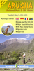
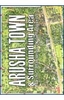

Arusha National Park
Arusha National Park in a series of brightly coloured maps of Tanzania’s national parks and conservation areas from Maco Editions` characteristic hand-drawn style of cartography. The maps include plenty of tourist information and enlargements for the most visited areas and hiking routes, with many titles providing a vivid picture of the changes to the terrain and vegetation during the dry and the wet seasons. The maps are illustrated in the margins with beautiful drawings of local flora and/or fauna and animal footprints for easy identification.*In this title:* a map of the park at approx.1:35, 000, showing tarmac roads and dirt tracks, paths, rangers’ posts, huts, campsites, viewpoints, etc. On the reverse, an enlargement at approx. 1:28, 500 and with contours at 200m
intervals covers the peak of Mt. Meru, indicating the main approaches to the summit, with huts and campsites. Also included are profiles of the southern route from the Momella Gate at 1500m to the Meru summit at 4566m. Neither the main map nor the enlargement shows any geographical coordinates.The map also provides information and advice for hikers and climbers and is illustrated with beautiful drawings of the local flora.
intervals covers the peak of Mt. Meru, indicating the main approaches to the summit, with huts and campsites. Also included are profiles of the southern route from the Momella Gate at 1500m to the Meru summit at 4566m. Neither the main map nor the enlargement shows any geographical coordinates.The map also provides information and advice for hikers and climbers and is illustrated with beautiful drawings of the local flora.
Product Description
Reviews/Comments
Add New
Vouchers
No voucher codes found.
Do you know a voucher code for this product or supplier? Add it to Insights for others to use.
Do you know a voucher code for this product or supplier? Add it to Insights for others to use.
 Denmark