
 United Kingdom
 France
 Germany
 Netherlands
 Sweden
 USA
USA
 Italy
Italy
 Spain
Spain
More From Contributor


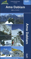
Ama Dablam
Mt. Everest area on a contoured and GPS-compatible map at 1:40, 000 from Nepa Maps, designed to show trekking routes from Namche, Tengboche and Pangboche towards the Ama Dablam and Imja Tse (Island Peak) Base Camps, and the continuation climbing routes towards these two peaks, Lhotse and Lhotse Star.With Thamo and Namche Bazar in the south-western corner of the map, coverage extends north to the Old Everest BC and the Kala Patthar viewpoint, and eastwards beyond the glaciers of Island Peak. The summits of Ama Dablam and Island Peak are annotated with arrows indicating views of the surrounding peaks. The map also shows the course of the main Everest Trek as far as the Old Everest BC, as well as the routes from Namche to Gokyo.The map has contours at 40m intervals, enhanced by relief
shading and colouring/graphics to show glaciers, forested areas, cultivated land, etc. Main trekking trails are highlighted, as are important settlements and locations with tourist accommodation including campsites, medical facilities, religious sites, etc. Latitude and longitude are shown by margin ticks at 2’30” intervals. The index lists places, base camps, peaks, passes and lakes. Map legend includes English.The map also includes basic street maps of Namche and Lukla indicating tourist accommodation and facilities, plus a small inset showing the area between these two main locations for exploring the Everest region.To see other titles in this series please click in the series link.
shading and colouring/graphics to show glaciers, forested areas, cultivated land, etc. Main trekking trails are highlighted, as are important settlements and locations with tourist accommodation including campsites, medical facilities, religious sites, etc. Latitude and longitude are shown by margin ticks at 2’30” intervals. The index lists places, base camps, peaks, passes and lakes. Map legend includes English.The map also includes basic street maps of Namche and Lukla indicating tourist accommodation and facilities, plus a small inset showing the area between these two main locations for exploring the Everest region.To see other titles in this series please click in the series link.

Product Description
Reviews/Comments
Add New
Vouchers
No voucher codes found.
Do you know a voucher code for this product or supplier? Add it to Insights for others to use.
Do you know a voucher code for this product or supplier? Add it to Insights for others to use.
 Denmark