
 United Kingdom
 France
 Germany
 Netherlands
 Sweden
 USA
USA
 Italy
Italy
 Spain
Spain
More From Contributor


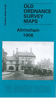
Altrincham 1908
Altrincham in 1908 in a fascinating series of reproductions of old Ordnance Survey plans in the Alan Godfrey Editions, ideal for anyone interested in the history of their neighbourhood or family. Selected towns in Great Britain and Ireland are covered by maps showing the extent of urban development in the last decades of the 19th and early 20th century.In this title: the map covers the centre of Altrincham, plus parts of Bowdon and Hale. Coverage stretches from Margaret Road eastward to Hermitage Road, and from Altrincham Market Place southward to East Downs Road, Bowdon. Features include railway with Altrincham & Bowdon and Hale stations, carriage shed, Stamford Park, Gas Works with tramway, Hale Moss area, Hydropathic Establishment, town centre in detail, Timperleyhall Farm,
with moat, Fish Pond, St Margaret's church, St Peter's church Hale, Culcheth Hall, Consumption Hospital, St John's church, Town Hall, Market Hall etc. On the reverse is a selection of street directory entries, including George Street, High Street, Moss Lane, New Street, Oxford Road, Shaw's Lane. About the Alan Godfrey Editions of the 25
with moat, Fish Pond, St Margaret's church, St Peter's church Hale, Culcheth Hall, Consumption Hospital, St John's church, Town Hall, Market Hall etc. On the reverse is a selection of street directory entries, including George Street, High Street, Moss Lane, New Street, Oxford Road, Shaw's Lane. About the Alan Godfrey Editions of the 25
Product Description
Reviews/Comments
Add New
Intelligent Comparison
Archived Product
Altrincham 1908 Stanfords
£3.50
Vouchers
No voucher codes found.
Do you know a voucher code for this product or supplier? Add it to Insights for others to use.
Do you know a voucher code for this product or supplier? Add it to Insights for others to use.
 Denmark