More From Contributor
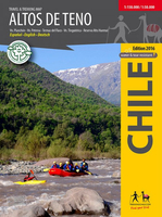
£10.99
Map No. 649, Altopiano della Paganella
- Dolomiti di Brenta, at 1:25, 000 from Kompass printed on sturdy, waterproof & tear-resistant
...
Archived Product
£10.99
Altopiano della Paganella
- L. di Tovel
- C. Brenta
- Trento in a series of Tabacco maps at 1:25, 000 covering the Dolomites


...
Archived Product
£10.99
Map No. 623, Altopiano di Asiago, at 1:25, 000 from Kompass printed on sturdy, waterproof & tear-resistant synthetic paper. The map is part of a series which provides more detailed coverage of the Dolomites & Lake Garda area & supplements the publishers` main series of walking maps of Italy at 1:50, 000. Maps in this series have a more detailed base & smaller contour interval than coverage at 1:50, 000.* Cartography:* maps at 1:25, 000 have contours at 25-m intervals. An overprint shows local & long-distance footpaths, including all the high level routes (Alte Vie). The maps also show the ”via ferrata” paths along the iron rails & ladders fitted into the rock faces. Other information

Includes::
various types of accommodation (campsites, alpine huts & refuges, etc.), recreational facilities, places of interest, local bus stops, etc. Many titles also have mountain bike trails or ski routes. Selected titles include on the reverse panorama drawings of the area, as indicated in the individual descriptions.* Geographical coordinates:* most maps are now GPS compatible
- titles without geographical coordinates are annotated to that effect in their individual description.* Map legend

Includes::
English.**PLEASE NOTE BEFORE ORDERING!* * Booklets:* many titles come with booklets describing the area and/or various hiking routes. These booklets are in * Italian & German only*, apart from a handful of titles where an English language booklet is specifically indicated in the individual description. So, unless English language booklet is actually mentioned, the map can only be supplied with an Italian/ German booklet. These booklets are not necessary to use the maps since, as stated above, full English language map legend is provided.


...
Archived Product
£10.99
Altopiano di Pinè
- Val di Cembra – Val di Mocheni area east & north-east of Trento in a series of Tabacco maps at 1:25, 000 covering
...
Archived Product
£8.50
Map No. 075, Altopiano di Piné
- Val di Cembra
- Val dei Mocheni, from Kompass in a series providing detailed coverage of

...
Archived Product
£11.50
Altötting in a series of GPS compatible recreational editions of the Bavarian topographic survey at 1:25, 000, with waymarked hiking trails & cycling routes, campsites & youth hostels, etc. Coverage

Includes::
Burghausen, Neuötting, Marktl, Burgkirchen a.d. Alz, Emmerting, Winhöring. Contours used in this map vary between 5 to 20m according to the terrain, with 20m interval predominantly used for hilly areas. Varied colouring show different types of landscape: woods, vineyards, fields etc. Maps in this series feature extensive overprint highlighting local & long-distance footpaths & cycle routes, including King Ludwig Way or different variants of the Way of St James, indicating their waymarking. Symbols highlight different types of accommodation (campsites, youth hostels, refuges, etc), sport & recreational facilities, various places of interest, etc. The maps have a 1-km UTM grid. Map legend & all the text are in German only. To see other titles in this series please click on the series link.

...
Archived Product
£2.95
Altrincham in 1908 in a fascinating series of reproductions of old Ordnance Survey plans in the Alan Godfrey Editions, ideal for anyone interested in the history of their neighbourhood or family. Selected towns in Great Britain & Ireland are covered by maps showing the extent of urban development in the last decades of the 19th & early 20th century. In this title: the map covers the centre of Altrincham, plus parts of Bowdon & Hale. Coverage stretches from Margaret Road eastward to Hermitage Road, & from Altrincham Market Place southward to East Downs Road, Bowdon. Features include railway with Altrincham & Bowdon & Hale stations, carriage shed, Stamford Park, Gas Works with tramway, Hale Moss area, Hydropathic Establishment, town centre in detail, Timperleyhall Farm, with moat, Fish Pond, St Margaret's church, St Peter's church Hale, Culcheth Hall, Consumption Hospital, St John's church, Town Hall, Market Hall etc. On the reverse is a selection of street directory entries, including George Street, High Street, Moss Lane, New Street, Oxford Road, Shaw's Lane. About the Alan Godfrey Editions of the 25 ...
Archived Product
£3.50
Altrincham in 1908 in a fascinating series of reproductions of old Ordnance Survey plans in the Alan Godfrey Editions, ideal for anyone interested in the history of their neighbourhood or family. The map covers the centre of Altrincham, plus parts of Bowdon & Hale. Coverage stretches from Margaret Road eastward to Hermitage Road, & from Altrincham Market Place southward to East Downs Road, Bowdon. Features include railway with Altrincham & Bowdon & Hale stations, carriage shed, Stamford Park, Gas Works with tramway, Hale Moss area, Hydropathic Establishment, Timperleyhall Farm, Fish Pond, St Margaret`s church, St Peter`s church Hale, Culcheth Hall, Consumption Hospital, St John`s church, Town Hall, Market Hall, etc. On the reverse is a selection of street directory entries, including George Street, High Street, Moss Lane, New Street, Oxford Road & Shaw`s Lane. About the Alan Godfrey Editions of the 25” OS Series: Selected towns in Great Britain & Ireland are covered by maps showing the extent of urban development in the last decades of the 19th & early 20th century. The plans have been taken from the Ordnance Survey mapping & reprinted at about 15 inches to one mile (1:4, 340). On the reverse most maps have historical notes & many also include extracts from contemporary directories. Most maps cover about one mile (1.6kms) north/south, one & a half miles (2.4kms) across; adjoining sheets can be combined to provide wider coverage.FOR MORE INFORMATION & A COMPLETE LIST OF ALL AVAILABLE TITLES PLEASE CLICK ON THE SERIES LINK. ...
Archived Product
£2.95
Altrincham North & Broadheath in 1897 in a fascinating series of reproductions of old Ordnance Survey plans in the Alan Godfrey Editions, ideal for anyone interested in the history of their neighbourhood or family. Selected towns in Great Britain & Ireland are covered by maps showing the extent of urban development in the last decades of the 19th & early 20th century. In this title: the map covers the northern part of Altrincham, Broadheath & parts of Timperley. Coverage stretches from St George's church & Woodlands Road northward to Timperley station. Features include Oldfield Nursery, Oldfield Hall, St George's church, railway with engine shed, Woodlands Park, Stamford House, Townfield House, Brookside Tannery, Atlantic Works, Linotype Works, LNWR line with Broadheath station, railway junctions, West Timperley station, Timperley station, Skelton Loop Line, Smith's Bridge, Riddings Hall, Pickering Lodge etc. On the reverse is a selection of street directory entries, including Barrington Road, Bridgewater Road, Brook Lane, Burlington Street, Church Street, Manchester Road, Navigation Road. About the Alan Godfrey Editions of the 25 ...
Archived Product
£3.50
Altrincham North & Broadheath in 1897 in a fascinating series of reproductions of old Ordnance Survey plans in the Alan Godfrey Editions, ideal for anyone interested in the history of their neighbourhood or family. The map covers the northern part of Altrincham, Broadheath & parts of Timperley. Coverage stretches from St George`s church & Woodlands Road northward to Timperley station. Features include Oldfield Nursery, Oldfield Hall, St George`s church, railway with engine shed, Woodlands Park, Stamford House, Townfield House, Brookside Tannery, Atlantic Works, Linotype Works, LNWR line with Broadheath station, railway junctions, West Timperley station, Timperley station, Skelton Loop Line, Smith`s Bridge, Riddings Hall, Pickering Lodge, etc. On the reverse is a selection of street directory entries, including Barrington Road, Bridgewater Road, Brook Lane, Burlington Street, Church Street, Manchester Road & Navigation Road. About the Alan Godfrey Editions of the 25” OS Series: Selected towns in Great Britain & Ireland are covered by maps showing the extent of urban development in the last decades of the 19th & early 20th century. The plans have been taken from the Ordnance Survey mapping & reprinted at about 15 inches to one mile (1:4, 340). On the reverse most maps have historical notes & many also include extracts from contemporary directories. Most maps cover about one mile (1.6kms) north/south, one & a half miles (2.4kms) across; adjoining sheets can be combined to provide wider coverage.FOR MORE INFORMATION & A COMPLETE LIST OF ALL AVAILABLE TITLES PLEASE CLICK ON THE SERIES LINK. ...
Archived Product

Altos De Teno

First map of the mountain range east of San Fernando and Curicó. General map 1: 150, 000 of the area between the Tinguiririca Volcano (4280 m) and the Peteroa - Azufre Volcano (4113 m), with the Planchón Volcano (3985 m), the Alto del Padre Hill (3349) and the Alto Huemul Private Reserve. Two maps detail 1: 50, 000: High Reserve Huemul and Planchón - Peteroa. With trekking routes, lines of height every 50 m, grid compatible with GPS, shelters, lodges, campings, etc. Photos of attractions and drawings of the local fauna. Map developed by the Cartography Institute of the Technical University of Dresden, Germany.
RIP - This product is no longer available on our network. It was last seen on 25.09.2019

This page now acts as a permanent archive for this product. Add more information using the comments box below to ensure it can still be found by future generations.

Use our search facility to see if it is available from an alternative contributor.
  • External links may include paid for promotion
  • Availability: Out Of Stock
  • Supplier: Stanfords
  • SKU: 9789568925307
Availability: In Stock
£10.99

Product Description

First map of the mountain range east of San Fernando & Curicó. General map 1: 150, 000 of the area between the Tinguiririca Volcano (4280 m) & the Peteroa
- Azufre Volcano (4113 m), with the Planchón Volcano (3985 m), the Alto del Padre Hill (3349) & the Alto Huemul Private Reserve. Two maps detail 1: 50, 000: High Reserve Huemul & Planchón
- Peteroa. With trekking routes, lines of height every 50 m, grid compatible with GPS, shelters, lodges, campings, etc. Photos of attractions & drawings of the local fauna. Map developed by the Cartography Institute of the Technical University of Dresden, Germany.

Reviews/Comments

Add New

Intelligent Comparison

Oooops!
We couldn't find anything!
Perhaps this product's unique.... Or perhaps we are still looking for comparisons!
Click to bump this page and we'll hurry up.

Price History

Vouchers

No voucher codes found.
Do you know a voucher code for this product or supplier? Add it to Insights for others to use.

Facebook

Jargon Buster

GPS - Global Positioning System - Global position using satellites
Germany - A country in Central Europe.
technical - Something that relates to a good level of skill and methods.

Supplier Information

Stanfords
Stanfords was established in 1853 and opened their iconic Covent Garden flagship store in 1901. They have become the top retailer of maps, travel books and accessories in the UK and arguably offer the largest selection of maps and travel books worldwide. Famous names such as Captain Robert Falcon Scott, Ranulph Fiennes and Michael Palin have purchased from Stanfords. They now have a shop in Bristol and both stores together with other venues operate a calendar of events including talks, book signings and exhibitions. As a specialist map retailer, the map selection is comprehensive and includes road maps, street maps and walking maps from worldwide destinations, as well as a selection of world atlases and wall maps. Books include travel guides and travel literature. Stanfords also stock globes, from miniatures made of blue marble to magnificent floor-standing globes. The website features a selection of interesting articles on travel topics.
Page Updated: 2023-11-12 20:15:36

Community Generated Product Tags

Oh No! The productWIKI community hasn't generated any tags for this product yet!
Menu