
 United Kingdom
 France
 Germany
 Netherlands
 Sweden
 USA
USA
 Italy
Italy
 Spain
Spain
More From Contributor


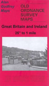
Sheffield Park 1903
Sheffield Park in 1903 in a fascinating series of reproductions of old Ordnance Survey plans in the Alan Godfrey Editions, ideal for anyone interested in the history of their neighbourhood or family. The map covers the south-eastern area of Sheffield, around Norfolk Park and Bramall Lane. Coverage stretches from Bramall Lane eastward to City Road Cemetery and from the southern end of the Midland station southward to Lowfield and Guernsey Road. Features include the railway approaches to the station with goods shed, engine turntable, sidings; tramways and depot; St Mary`s church, Bramall Lane football ground, Sheaf House Ground, Havelock Bridge Works, Norfolk Park, Park Grange, Arbourthorne, Clay Wood, Granville Road area, Beech Hill, etc. Street directories for Bramall Lane,
Granville Road, Queen`s Road and Shoreham Street are on the reverse.About the Alan Godfrey Editions of the 25” OS Series:Selected towns in Great Britain and Ireland are covered by maps showing the extent of urban development in the last decades of the 19th and early 20th century. The plans have been taken from the Ordnance Survey mapping and reprinted at about 15 inches to one mile (1:4, 340). On the reverse most maps have historical notes and many also include extracts from contemporary directories. Most maps cover about one mile (1.6kms) north/south, one and a half miles (2.4kms) across; adjoining sheets can be combined to provide wider coverage.FOR MORE INFORMATION AND A COMPLETE LIST OF ALL AVAILABLE TITLES PLEASE CLICK ON THE SERIES LINK.
Granville Road, Queen`s Road and Shoreham Street are on the reverse.About the Alan Godfrey Editions of the 25” OS Series:Selected towns in Great Britain and Ireland are covered by maps showing the extent of urban development in the last decades of the 19th and early 20th century. The plans have been taken from the Ordnance Survey mapping and reprinted at about 15 inches to one mile (1:4, 340). On the reverse most maps have historical notes and many also include extracts from contemporary directories. Most maps cover about one mile (1.6kms) north/south, one and a half miles (2.4kms) across; adjoining sheets can be combined to provide wider coverage.FOR MORE INFORMATION AND A COMPLETE LIST OF ALL AVAILABLE TITLES PLEASE CLICK ON THE SERIES LINK.

Product Description
Reviews/Comments
Add New
Intelligent Comparison
Archived Product

Sheffield Darnall 1903 Stanfords
£3.50
Archived Product
Sheffield North 1903 Stanfords
£3.50
Archived Product

Sheffield West 1903 Stanfords
£3.50
Archived Product

Sheffield Central 1903 Stanfords
£3.50
Archived Product

Sheffield Heeley 1903 Stanfords
£3.50
Archived Product

Sheffield Handsworth 1901 Stanfords
£3.50
Archived Product
Sheffield And Doncaster 1903 Stanfords
£9.99
Archived Product
Sheffield Neepsend 1903 Stanfords
£2.95
Vouchers
No voucher codes found.
Do you know a voucher code for this product or supplier? Add it to Insights for others to use.
Do you know a voucher code for this product or supplier? Add it to Insights for others to use.
 Denmark