
 United Kingdom
 France
 Germany
 Netherlands
 Sweden
 USA
USA
 Italy
Italy
 Spain
Spain
More From Contributor


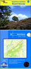
North Wales 1722
A New And Correct Map Of North Wales, an original antique map by R. Morden / Anonymous, published in London, 1722-. Copperplate, coloured. Map size 43 x 36 cm, overall mounted size 59 x 52 cm.Following the appearance in 1695 of Morden's map of Wales there were complaints of errors and omissions. This is the new and corrected plate of 1722 - based on Morden's. Although anonymous, the style of engraving very much resembles that of Andrew Johnston who created new maps of Scotland for this edition. Robert Morden (d.1703) was commissioned to engrave a set of county maps for Edmund Gibson's new edition. Morden's first series of maps were rejected as being too small, and these were laterpublished in Morden's New Description and State of England, first issued in 1701, and subsequently
re-issued in Cox's Magna Britannia, in the 1720s. Morden finally produced a new set of maps on a larger scale which were used in Gibson's editions published in 1695, 1722, circa 1730, 1753 1772, as here. The maps were based on the most up-to-date surveys where available, although some drew on Saxton and Speed, and were engraved by Sutton Nicholls and John Sturt. Their detail, convenient size, visual attraction and antiquity make them among the most popular of all early county maps. Antique maps from various original publishers are presented on the Stanford
re-issued in Cox's Magna Britannia, in the 1720s. Morden finally produced a new set of maps on a larger scale which were used in Gibson's editions published in 1695, 1722, circa 1730, 1753 1772, as here. The maps were based on the most up-to-date surveys where available, although some drew on Saxton and Speed, and were engraved by Sutton Nicholls and John Sturt. Their detail, convenient size, visual attraction and antiquity make them among the most popular of all early county maps. Antique maps from various original publishers are presented on the Stanford
Product Description
Reviews/Comments
Add New
Intelligent Comparison
Archived Product
North Walsham 1926 Stanfords
£2.95
Archived Product

North Walsham 1926 Stanfords
£3.50
Archived Product
North Wales 1848-1852 Stanfords
£160.00
Archived Product
North Wales 1765-1768 Stanfords
£140.00
Archived Product
South Wales 1695-1722 Stanfords
£300.00
Vouchers
No voucher codes found.
Do you know a voucher code for this product or supplier? Add it to Insights for others to use.
Do you know a voucher code for this product or supplier? Add it to Insights for others to use.
 Denmark