
 United Kingdom
 France
 Germany
 Netherlands
 Sweden
 USA
USA
 Italy
Italy
 Spain
Spain
More From Contributor


Greenland Wall Map
This 120x72cm large wallmap clearly shows the difference between Greenland`s ice-free coastal areas and the icy interior. The interior shows only contours at 500m intervals. The coast, however, is shown by elevations tinting (i.e. different colours for different altitudes) and spot heights. Towns and settlements are clearly marked, as are fjords, sounds, airports and hydro-electric plants. National parks and administrative boundaries are shown. Lines of latitude and longitude are shown.

Product Description
Reviews/Comments
Add New
Intelligent Comparison
Archived Product

Iceland Wall Map Stanfords
£15.99
Archived Product

New Zealand Wall Map Stanfords
£13.50
Archived Product

Iran Wall Map Stanfords
£13.50
Archived Product
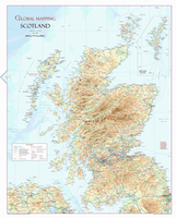
Scotland Wall Map Stanfords
£9.99
Archived Product
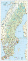
Sweden Wall Map Stanfords
£24.95
Archived Product
Holy Land Wall Map Stanfords
£13.95
Archived Product

Caribbean Wall Map Stanfords
£27.00
Archived Product

Iraq Wall Map Stanfords
£13.50
Vouchers
No voucher codes found.
Do you know a voucher code for this product or supplier? Add it to Insights for others to use.
Do you know a voucher code for this product or supplier? Add it to Insights for others to use.
 Denmark