
 United Kingdom
 France
 Germany
 Netherlands
 Sweden
 USA
USA
 Italy
Italy
 Spain
Spain
More From Contributor


Caribbean Wall Map
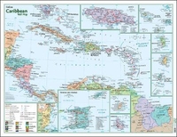
This 121x88cm map is designed to be displayed on the wall (it has brass eyelets in each corner) and is printed on laminated paper for durability. The main map shows the Caribbean from Florida to northern Colombia and from Guatemala to Surinam, including all the islands. Each country/island is shown in a different, bright colour. Rivers and major roads are drawn, major towns and capitals cities are marked, and airports and major ports are also indicated. For each island nation the national flag is displayed. Latitude and longitude lines are at 5 degree intervals. There are five inset maps at larger, more detailed scales, four of which show the internal administrative boundaries of Barbados, Belize, Jamaica and Trinidad respectively. The fifth inset map is an enlargement of the
Virgin Islands and Leeward Islands at 1:1, 540, 000. While the map would be ideal for the classroom, it is professionally drawn and would look equally good in the office or home.
Virgin Islands and Leeward Islands at 1:1, 540, 000. While the map would be ideal for the classroom, it is professionally drawn and would look equally good in the office or home.

Product Description
Reviews/Comments
Add New
Intelligent Comparison
Archived Product
Caribbean Collins Wall Map Stanfords
£7.99
Archived Product

Iran Wall Map Stanfords
£13.50
Archived Product

Caribbean Marco Polo Map Stanfords
£6.99
Archived Product

Mauritania Wall Map Stanfords
£13.50
Archived Product
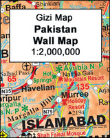
Pakistan Wall Map Stanfords
£13.50
Archived Product

Brittany Wall Map Stanfords
£17.99
Archived Product

Greenland Wall Map Stanfords
£44.99
Archived Product

Bali Wall Map Stanfords
£14.99
Vouchers
No voucher codes found.
Do you know a voucher code for this product or supplier? Add it to Insights for others to use.
Do you know a voucher code for this product or supplier? Add it to Insights for others to use.
 Denmark