More From Contributor

£16.99
Australia on a wall map at 1:6, 413, 000,

Size:
77 x 60cm (30” x 24” approx) – encapsulated version, presenting

...
Archived Product
£12.99
Australia on a wall map at 1:6, 413, 000,

Size:
77 x 60cm (30” x 24” approx) – paper version, presenting

...
Archived Product
£12.99
Australia on a wall map at 1:6, 413, 000,

Size:
77 x 60cm (30” x 24” approx) – paper version, from the

...
Archived Product
£6.99
Australia on an overview map from Periplus accompanied by enlargements of its most visited areas plus street plans of the five main cities, shown on panels on both sides of the sheet. All the maps are annotated with numerous places of interest & street plans in addition show locations of hotels. A general map covers the country at 1:7, 700, 000 showing the network of main roads & railways, principal national parks & aboriginal lands. Separate panels with more detailed road maps & street plans show provide coverage of:
- REGIONAL MAPS: Sydney with the Blue Mountains National Park & extending north to Newcastle, plus Brisbane with Gold Coast (both at 1: 650, 000)- ENVIRONS MAPS: Greater Sydney (1:120, 000), Greater Melbourne (1:150, 000), plus the environs of Cairns, Darwin, Adelaide & Perth (1:250, 000/1:300, 000)- STREET PLANS: Sydney, Melbourne, Brisbane, Adelaide & Perth (1:10, 000/17, 500)
...
Archived Product
£6.99
Australia in the Pocket Guide series from Berlitz; a collection of handy, pocket-sized guides dedicated to an extensive range of cities, regions & countries worldwide. Written in narrative form, individual guides explore the history, main sights & attractions, food & drink, accommodation & local culture of the destination in detail. Each Berlitz pocket guide has a similar format, with colour-coded sections helping readers locate information quickly in addition to distinctive chapters exploring the city or region. An introduction outlines the destination for visitors & a section dedicated to 'A Brief History' actually explores the area in relative depth. A where to go chapter is organized by region & city & is written in prose form with references to individual sites highlighted in bold for clarity. There are also further suggestions on where & when to eat. Recommendations for leisure activities in the region, including sport, nightlife & shopping, are also provided & tailored accordingly for each destination. Handy travel tips are listed alphabetically in a dedicated section, providing practical guidance & helping visitors make the most of their stay. The main hotels, particularly for cities, are also listed in an accommodation section, offering a brief overview with approximate price bandings & relevant contact details. ...
Archived Product
£6.95
This map is the same as the UBD road map of Australia, but with numerous annotations added. Roads are clearly shown, indicating whether they are surfaced or unsurfaced. Colours distinguish reserves, national parks, aboriginal land & prohibited areas. However the print is rather small to read. Indexed for major cities & towns. On the reverse
- information on 76 holiday highlights nationwide.
...
Archived Product
£8.50
This map is the same as the UBD road map of Australia, but with numerous annotations added. Roads are clearly shown, indicating whether they are surfaced or unsurfaced. Colours distinguish reserves, national parks, aboriginal land & prohibited areas. However the print is rather small to read. Indexed for major cities & towns. On the reverse
- information on 76 holiday highlights nationwide.
...
Archived Product
£6.99
Handy pocket size map of Australia Australia map projection-Lamberts conformal conic at a scale of 1:5 800 000 Features eastern & middle Australia on 1 side (Queensl&, New South Wales, ` Victoria, Northern Territory, South Ausralia & Tasmania) & western & middle Australia on the other side (Western Australia, Northern Territory & South Australia) Also

Includes::
index to cities & towns for each side

...
Archived Product
£11.50
Australia at 1:4, 000, 000 on an indexed road map with topographic & tourist information, printed on light, waterproof & tear-resistant plastic paper. The map, published by Reise Know-How as part of their highly acclaimed World Mapping Project, is double-sided to provide the best balance between a good scale & a convenient size sheet. Road network is shown on a base with light altitude colouring & contours showing the country’s topography. Principal highways & many local roads & outback tracks are named, with driving distances shown on main routes. Railway lines are included & local airports are marked. National parks & other protected areas, Aboriginal lands & restricted entry zones are indicated. The map also highlights various places of interest. Latitude & longitude lines are drawn at intervals of 1°. The index

Includes::
a long list of national parks & protected areas.

...
Archived Product
£11.99
Australia Road Atlas from the AA with cartography from the Australian publishers Hema, in a large, 25x 35cm, 118-page paperback format, with states shown at varying scales & additional more detailed mapping for environs of the state capital, plus a street plan of the city itself. Currnet edition of this atlas was published in January 2010 with cartography from 2009. Each state is covered at a different scale depending on its size. Mapping is an enlargement of Hema ...
Archived Product

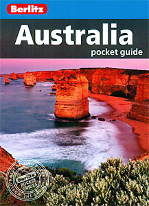
Australia Pocket Guide

From dazzling Sydney and the stunning Great Ocean Road to the majestic monolith of Uluru, Australia has much to tempt the visitor. Berlitz Pocket Guide Australia is a concise, full-colour travel guide that combines lively text with vivid photography to highlight the best of Down Under. The Where To Go chapter details all the key sights in the country, while handy maps on the cover flaps help you find your way around, and are cross-referenced to the text. To inspire you, the guide offers a rundown of the Top 10 Attractions in Australia, followed by an itinerary for a Perfect Tour of the country. The What to Do chapter is a snapshot of ways to spend your spare time, from catching a rugby match and snorkelling on the Great Barrier Reef to exploring the citys` lively markets and finding
the best nightlife. The book provides all the essential background on Australia`s culture, including a history of the country and an Eating Out chapter covering the country`s diverse cuisine. There is also an A-Z of all the practical information you`ll need to make the most of your trip.
RIP - This product is no longer available on our network. It was last seen on 25.09.2019

This page now acts as a permanent archive for this product. Add more information using the comments box below to ensure it can still be found by future generations.

Use our search facility to see if it is available from an alternative contributor.
  • External links may include paid for promotion
  • Availability: Out Of Stock
  • Supplier: Stanfords
  • SKU: 9781780041407
Availability: In Stock
£6.99

Product Description

From dazzling Sydney & the stunning Great Ocean Road to the majestic monolith of Uluru, Australia has much to tempt the visitor. Berlitz Pocket Guide Australia is a concise, full-colour travel guide that combines lively text with vivid photography to highlight the best of Down Under. The Where To Go chapter details all the key sights in the country, while handy maps on the cover flaps help you find your way around, & are cross-referenced to the text. To inspire you, the guide offers a rundown of the Top 10 Attractions in Australia, followed by an itinerary for a Perfect Tour of the country. The What to Do chapter is a snapshot of ways to spend your spare time, from catching a rugby match & snorkelling on the Great Barrier Reef to exploring the citys` lively markets & finding the best nightlife. The book provides all the essential background on Australia`s culture, including a history of the country & an Eating Out chapter covering the country`s diverse cuisine. There is also an A-Z of all the practical information you`ll need to make the most of your trip.

Reviews/Comments

Add New

Intelligent Comparison

Oooops!
We couldn't find anything!
Perhaps this product's unique.... Or perhaps we are still looking for comparisons!
Click to bump this page and we'll hurry up.

Price History

Vouchers

No voucher codes found.
Do you know a voucher code for this product or supplier? Add it to Insights for others to use.

Facebook

Jargon Buster

Key - A physical or virtual device or code used for opening something
History - Anything that happens in the past. An acedemic subject.
Colour - The categorised spectrum of light visable to humans
Road - a manmade lane or a path that is used to speed up travel.
Practical - Weather a task is easy to carry out and realistically succeed.
Pocket - A bag shaped insert in clothing used to carry items

Supplier Information

Stanfords
Stanfords was established in 1853 and opened their iconic Covent Garden flagship store in 1901. They have become the top retailer of maps, travel books and accessories in the UK and arguably offer the largest selection of maps and travel books worldwide. Famous names such as Captain Robert Falcon Scott, Ranulph Fiennes and Michael Palin have purchased from Stanfords. They now have a shop in Bristol and both stores together with other venues operate a calendar of events including talks, book signings and exhibitions. As a specialist map retailer, the map selection is comprehensive and includes road maps, street maps and walking maps from worldwide destinations, as well as a selection of world atlases and wall maps. Books include travel guides and travel literature. Stanfords also stock globes, from miniatures made of blue marble to magnificent floor-standing globes. The website features a selection of interesting articles on travel topics.
Page Updated: 2023-11-12 20:15:36

Community Generated Product Tags

Oh No! The productWIKI community hasn't generated any tags for this product yet!
Menu