
 United Kingdom
 France
 Germany
 Netherlands
 Sweden
 USA
USA
 Italy
Italy
 Spain
Spain
More From Contributor


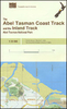


Abel Tasman Coast Track
Abel Tasman Coast Track and the Inland Track in the Abel Tasman National Park at 1:55, 000 in a series of contoured and GPS compatible maps from NewTopo NZ Ltd, with exceptionally vivid presentation of the terrain, routes clearly highlighted, and symbols to show locations of various facilities. In addition to the two routes the map also shows other local footpaths, as well as boat ramps and water taxi connections. Contour interval is 20m.Maps in the series from NewTopo NZ Ltd cover the country
Product Description
Reviews/Comments
Add New
Vouchers
No voucher codes found.
Do you know a voucher code for this product or supplier? Add it to Insights for others to use.
Do you know a voucher code for this product or supplier? Add it to Insights for others to use.
 Denmark