
 United Kingdom
 France
 Germany
 Netherlands
 Sweden
 USA
USA
 Italy
Italy
 Spain
Spain
More From Contributor


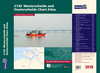

2100 Kent And Sussex Coasts Chart Atlas - 2018 Edition
For this February 2018 edition the latest depth surveys have been applied. The latest wind farm information is included where relevant. There has been general updating throughout.The 2018 edition is now wirobound and tidal stream information is included. Individual sheets of this atlas will no longer be sold separately. However, 1st edition charts Y7 and Y14 will be published. These are replicas of charts 2100.1 and 2100.5.Chart included in the atlas are:2100.1 Thames Estuary South1: 120 000 WGS 842100.2 River Thames Sea Reach1: 50 000 WGS 842100.3 The River Thames - Queen Elizabeth Bridge to Canvey Island1: 35 000 WGS 84Plans Coalhouse Point to Canvey Island, Queen Elizabeth II Bridge to Coalhouse Point2100.4 The River Thames - Tower Bridge to Queen Elizabeth Bridge1: 35 000 WGS 84Plans
Barking Creek to Queen Elizabeth II Bridge, Tower Bridge to Barking Creek2100.5 River Medway1: 40 000 WGS 84Plans Gillingham Marina, Port Werburgh, Whitton Marine, Continuation of River Medway2100.6 The Swale1: 40 000 WGS 84Plans Whitstable Harbour2100.7 North Foreland to Dover & Calais1: 115 000 WGS 842100.8 Dover to Dungeness & Cap Gris-Nez1: 115 000 WGS 842100.9 Beachy Head to Dungeness1: 115 000 WGS 84Plans Sovereign Harbour, Rye Harbour2100.10 Nab Tower to Beachy Head1: 160 000 WGS 842100.11 Kent Plans - including plan of Calais1: various WGS 84Plans Ramsgate, River Stour Entrance, Dover, Calais, Folkestone2100.12 Sussex Plans1: various WGS 84Plans Newhaven, Brighton Marina, Shoreham Harbour, Littlehampton, The Looe
Barking Creek to Queen Elizabeth II Bridge, Tower Bridge to Barking Creek2100.5 River Medway1: 40 000 WGS 84Plans Gillingham Marina, Port Werburgh, Whitton Marine, Continuation of River Medway2100.6 The Swale1: 40 000 WGS 84Plans Whitstable Harbour2100.7 North Foreland to Dover & Calais1: 115 000 WGS 842100.8 Dover to Dungeness & Cap Gris-Nez1: 115 000 WGS 842100.9 Beachy Head to Dungeness1: 115 000 WGS 84Plans Sovereign Harbour, Rye Harbour2100.10 Nab Tower to Beachy Head1: 160 000 WGS 842100.11 Kent Plans - including plan of Calais1: various WGS 84Plans Ramsgate, River Stour Entrance, Dover, Calais, Folkestone2100.12 Sussex Plans1: various WGS 84Plans Newhaven, Brighton Marina, Shoreham Harbour, Littlehampton, The Looe

Product Description
Reviews/Comments
Add New
Vouchers
No voucher codes found.
Do you know a voucher code for this product or supplier? Add it to Insights for others to use.
Do you know a voucher code for this product or supplier? Add it to Insights for others to use.
 Denmark