More From Contributor
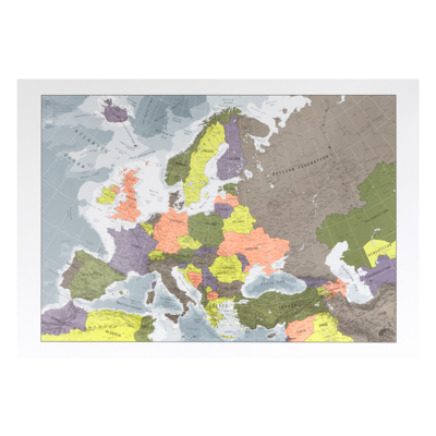
£12.99
Situated between the Highlands to the north & the Southern Uplands to the south, Edinburgh occupies a remarkable position. This walking guidebook has 20 circular walks all graded by route & difficulty, ideal for planning day trips or longer holidays to Scotland's capital. Each route

Includes::
detailed directions, an OS Explorer map extract for the route, notes on parking, GPS waypoints & key things to look for on the way. Walks based in & around the city take full advantage of geological & historical features such as Arthur’s Seat, Holyrood Park, Blackford Hill & its observatory. Go further afield to the area surrounding this fascinating city for an impressive landscape of coastal panoramas & breathtaking views. Walking include Gamelshiel Castle, Linlithgow Loch, the Pentland Ridge & part of the John Muir Way. Routes are from 5km (3 miles) to 18km (11 miles), so there is something for all ages & abilities. This book is part of a series of Pathfinder walking guidebooks designed to help both visitors & locals discover the best routes each area has to offer.

...
Archived Product
£24.99
Put on your running shoes – it’s time to hit the road, the trails & the great outdoors. In this comprehensive runner’s companion, you’ll find 50 of the world’s greatest running routes – from short city runs & must-do marathons to cross-country trails & challenging ultras – plus a further 150 courses around the globe to satisfy runners of all abilities. Each run is accompanied by stunning photos & a map & toolkit of practical details – where to start & finish, how to get there, where to stay & more – to help you plan the perfect trip. Suggestions for similar runs around the world are also included. Organised by continent, Lonely Planet’s Epic Runs of the World takes runners past giraffes, zebras & rhinos in Africa, along courses the length of Vancouver’s Stanley Park Seawall in the Americas, offers spectacular views of Hong Kong from Victoria Peak in Asia & jogs along Rome’s Tiber River in Europe, while inviting athletes to push themselves to the limit in Oceania’s Blue Mountains Ultra. What's inside: Runs in Africa include: The Lewa Safari Marathon (Kenya), Marathon Des Sables (Morocco), The Great Ethiopian Run, The Comrades Ultramarathon (South Africa) Runs in the Americas include: The Big Sur Marathon (USA), Havana’s El Malecon (Cuba), Rio at Dawn (Brazil), An Illuminating Ascent in La Paz (Bolivia) Runs in Asia include: The Great Wall Marathon (China), Angkor Wat Half Marathon (Cambodia), A Temple Ascent in Pokhara (Nepal), Kyoto’s Riverside (Japan) Runs in Europe include: Amalfi Coast’s Path of the Gods (Italy), A Classic Fell Run in the Lakes (England), The Athens Marathon (Greece), Dublin’s Wild Side (Ireland) Runs in Oceania include: Great Ocean Road Marathon (Australia), The Kepler Track (New Zealand), Freycinet Peninsula (Tasmania), A Ghost Run in Waihi Gorge (New Zealand) About Lonely Planet Lonely Planet is a leading travel media company, providing both inspiring & trustworthy information for every kind of traveller since 1973. Over the past four decades, we've printed over 145 million guidebooks & phrasebooks for 120 languages, & grown a dedicated, passionate global community of travellers. You'll also find our content online, & in mobile apps, videos, 14 languages, armchair & lifestyle books, ebooks, & more, enabling you to explore every day. ...
Available
£3.99
Explore Secret Stories Epsom Downs: Crooks & Aristocrats Tour, a self-guided interactive walking tour to enjoy whenever you want. The route starts & ends with a panoramic view over London from Epsom Downs, (and a free car park!) where you will imagine London of the 17th century through the eyes of diarist Samuel Pepys. Discover how to kidnap a horse, how to win the vote (or die trying) & who created the deadly necropolis beneath your feet. You will also delve into the history of the famous Epsom racecourse, & meet Emily Davison, the lady who gave her life protesting for change. Total length: 3.19 miles; Suggested age range: 7+ Purchase this Tour (and more) in the Secret Stories App, available for free download from Android Play & Apple App store. You'll find more details of the tour & what it contains in the app! ...
Available
£3.99
Explore Secret Stories Epsom's Spa, Suffragette & Skyline Tour, a self-guided interactive walking tour to enjoy whenever you want. Uncover stories about two pioneering women — one who fought for the right to vote, the other who taught the Victorians to cook. Visit a world-renowned racecourse & explore a nature reserve rich in wildlife. Learn about Epsom’s history as a spa town & enjoy sweeping views of the capital. Total length: 3.7 miles; Suggested age range: 11+ Purchase this Tour (and more) in the Secret Stories App, available for free download from Android Play & Apple App store. You'll find more details of the tour & what it contains in the app! ...
Available
£12.99
This book has 28 circular, graded walks all around Essex. The routes range from extended 4.8km (3 miles) up to 15.6km (10 miles), so there is something for everyone of all abilities. Each walk

Includes::
a detailed description, an extract of the OS Explorer 1:25k map, GPS waypoints & key features to look out for. You can also find information on parking, refreshments & more. The Essex landscape gently undulates, with the hilliest country is in the north & west, near the Hertfordshire & Cambridgeshire borders. On the marshes of Essex, for example, there is a genuine feeling of solitude that is hard to find anywhere else in southern Engl&. Routes include Burnham, Epping Forest, the Blackwater Estuary, The Naze, Stour Valley & two country parks.

...
Archived Product
£12.99
Weave a little wonder into daily life with these fun & challenging activities
- & experience your local area in a whole new way.
...
Available
£3.99
Explore Secret Stories Ewhurst's Windmill & Winged Wonders Tour, a self-guided interactive walking tour to enjoy whenever you want. Get ready to explore the Hurtwood’s 2, 000 acres of forest & heathl&. Wander through a magical wildflower meadow & see how many kinds of butterflies you can spot. Discover what it's like living in a windmill, ponder the mystery of the hidden Roman villa, & uncover ancient hedgerows crammed with tasty morsels to eat. Total length: 2.4 miles; Suggested age range: 7+ Purchase this Tour (and more) in the Secret Stories App, available for free download from Android Play & Apple App store. You'll find more details of the tour & what it contains in the app! ...
Available
£12.99
Exmoor National Park comprises 265 square miles, of which about two-thirds lie in west Somerset & the remaining third in north Devon. This walking guidebook contains 28 circular, graded walks in Exmoor, all tried & tested by seasoned walkers. The routes range from extended strolls to longer hikes, so there is something for everyone. The routes range from three to eleven miles in length & each is also rated for difficulty. Each walk

Includes::
a detailed description, an OS map, GPS waypoints & notes of key features & things to see. Routes include the Bristol Channel coast, stretching in a dramatic series of cliffs interrupted only by the Vale of Porlock, from North Hill above Minehead in the east to Little Hangman above Combe Martin in the west. Pathfinder Guides are Britain’s best-loved walking guides. Printed with weather-resistant covers featuring durable rounded corners, they are the perfect companion for country walking throughout Britain.

...
Archived Product
£7.99
This guidebook for Exmoor has 20 amazing circular walks for families, from 3.5km to 10km, each created by local expert Sue Viccars. Each walking route has written directions, a local area OS map, notes & photos of key features, wildlife & history to discover on the way. Exmoor itself has wide expanses of heather & rich woodl&, along with varied wildlife such as red deer. Walks in this guide include Parracombe, Pinkworthy Pond, the picturesque medieval town of Dunster & Horner Wood. ...
Archived Product
£54.99
The expert SILVA compass, now with a global needle! The Expedition Global is for experienced users & professionals. It is high performing when it comes to accuracy, precision & durability. The global needle also makes the compass flexible & possible to use all around the world. If you are in need of a compass with high-end features to use anywhere in the world, the Expedition Global should be your choice. The compass comes with a slope card & a distance lanyard. The slope card is great both for detecting avalanche risk & for determining how challenging your journey will be. By knowing the slope you can also judge any extra distance that you need to go due to the slope. The distance lanyard has two scales on it; 1:25, & 1:50, which facilitates to measure the distance of your hike. Since its soft & bendable it’s easy to place it directly on to your route on the map. ...
Available

Europe Wall Map

Educational and enlightening. An information-rich reference map sure to dazzle and delight the Europhile. The levels of information on this map go well beyond the ordinary, with our signature layered metallic sea-levels (who knew the Black Sea was deeper than any of the seas surrounding the British Isles?) Swot up on your capital cities and your population densities, your mountain ranges and your major rivers. Never mind GCSE geography, your next pub quiz is going to be a walkover. The maps are printed to the highest quality FSC approved silk-coated paper using a lithographic printing process. This works like a mechanised version of traditional screen-printing. A plate is made for each colour and then laid down individually, offering a stunning-quality print, with great definition and
colour impact. A sealer is applied to protect the inks and gloss UV varnish used to add contrast and highlight boundaries.
Availability: In Stock
£29.00

Product Description

Educational & enlightening. An information-rich reference map sure to dazzle & delight the Europhile. The levels of information on this map go well beyond the ordinary, with our signature layered metallic sea-levels (who knew the Black Sea was deeper than any of the seas surrounding the British Isles?) Swot up on your capital cities & your population densities, your mountain ranges & your major rivers. Never mind GCSE geography, your next pub quiz is going to be a walkover. The maps are printed to the highest quality FSC approved silk-coated paper using a lithographic printing process. This works like a mechanised version of traditional screen-printing. A plate is made for each colour & then laid down individually, offering a stunning-quality print, with great definition & colour impact. A sealer is applied to protect the inks & gloss UV varnish used to add contrast & highlight boundaries.

Reviews/Comments

Add New

Price History

Vouchers

No voucher codes found.
Do you know a voucher code for this product or supplier? Add it to Insights for others to use.

Facebook

Jargon Buster

Silk - A natural fibre made by silk worms
Paper - A thin sheet mainly used for writing. Available in a variety of colours. Made mainly from wood pulp.
Black - A colour which does not emit any colour of the spectrum. Black absorbs all frequencies of the spectrum.
UV - Ultraviolet - a specific wavelength of light invisible to the human eye
screen-printing - A printing technique using woven mesh to support an ink blocking stencil.
Wall - A physical barrier between two areas
Colour - The categorised spectrum of light visable to humans
Quality - An object that has quality is superior in function and finish than a less quality object.
Traditional - Something that has become the same through a period of time and thus repeated.
Traditional - Something that has been around for a while and is repeated regularly.
Reference - To prove evidence with a back up source.
Print - A mechanical process of putting text onto paper. It can also relate to a pattern on an item.

Supplier Information

Ordnance Survey
Navigate your world with confidence with Ordnance Survey (https://shop.ordnancesurvey.co.uk/)! Explore our extensive range of maps, guides, and outdoor gear designed to help you explore the great outdoors with ease. From detailed maps for hiking and cycling to innovative GPS devices, we've got everything you need to plan your next adventure. With our heritage of accuracy and reliability, Ordnance Survey is your trusted companion for exploring the UK's landscapes, whether you're a seasoned explorer or a weekend wanderer. Gear up and discover new horizons with Ordnance Survey today!
Page Updated: 2024-03-04 13:47:34

Community Generated Product Tags

Oh No! The productWIKI community hasn't generated any tags for this product yet!
Menu