More From Contributor

£89.00
A larger sized 3D map showing all of Dartmoor, including Oakhampton, Bovey Tracey & part of Plymouth. The map is based on Ordnance Survey Landranger mapping, so shows roads, points of interest & other features. The map is 67cm x 76cm, slightly larger for the framed version. It is available as a plain map on rigid plastic, or frameless mounted, or mounted with a choice of frames. Due to the size of these products they will be sent by courier only. Please add to cart & review the price for delivery to your address in the checkout. ...
Archived Product
£99.00
A larger sized 3D map showing all of Dartmoor, including Oakhampton, Bovey Tracey & part of Plymouth. The map is based on Ordnance Survey Landranger mapping, so shows roads, points of interest & other features. The map is 67cm x 76cm, slightly larger for the framed version. It is available as a plain map on rigid plastic, or frameless mounted, or mounted with a choice of frames. Due to the size of these products they will be sent by courier only. Please add to cart & review the price for delivery to your address in the checkout. ...
Archived Product
£60.00
A larger sized 3D map showing all of Dartmoor, including Oakhampton, Bovey Tracey & part of Plymouth. The map is based on Ordnance Survey Landranger mapping, so shows roads, points of interest & other features. Scale: 1: 60 000 Map measures approximately*: H 76 x W 68 x D 1.8 cm * All measurements are approximate. ...
Available
£149.99
This raised relief map of France is manufactured by Dorrigo & provides a unique overview of the whole country, including the Alps & Pyrenees mountain ranges. The simplified mapping shows key physical features, including the mountain ranges with spot heights of peaks. All main roads, rivers, towns, cities & regions are also clearly shown. This 3D map of France also shows parts of the surrounding countries of Spain, Belgium & Germany. It's ideal for fans of summer or winter sports. Due to the size of these products they will be sent by courier only. Please add to cart & review the price for delivery to your address in the checkout. ...
Archived Product
£69.99
This raised relief map of Germany is manufactured by Dorrigo & provides a unique overview of the whole country. The simplified mapping shows key physical features, including the Bavarian Alps with spot heights of peaks. All main roads, rivers, towns, cities & regions are also clearly shown. This 3D map of Germany also shows parts of the surrounding countries. Due to the size of these products they will be sent by courier only. Please add to cart & review the price for delivery to your address in the checkout. ...
Archived Product
£59.99
This raised relief map of Italy is manufactured by Dorrigo & provides a unique overview of the whole country, including the Italian Alps & the islands of Sicily, Sardinia & Corsica. The simplified mapping shows key physical features, including the mountain ranges with spot heights of the peaks. All main roads, rivers, towns, cities & regions are also clearly shown. This 3D map of France also shows parts of the surrounding countries of France, Switzerl&, Austria & Slovenia. Due to the size of these products they will be sent by courier only. Please add to cart & review the price for delivery to your address in the checkout. ...
Archived Product
£165.99
This raised relief map has been created based on data from by IGN (Institut national de l’information géographique et forestière) & shows the area around Mont Blanc including the massif itself & surrounding peaks. Major towns include Annecy, Martigny Ville, Geneve & Albertville. The simplified mapping shows key physical features, including the mountain ranges with spot heights of peaks, glaciers, ski lifts, villages & viewpoints. All main roads, rivers, & other features are also clearly shown. This 3D map for this popular skiing & walking area is ideal for teaching or display. Due to the size of these products they will be sent by courier only. Please add to cart & review the price for delivery to your address in the checkout. ...
Archived Product
£165.99
This raised relief map has been created based on data from by IGN & shows the area around Mont Blanc including the massif itself & surrounding peaks. Major towns include Annecy, Martigny Ville, Geneve & Albertville. The simplified mapping shows key physical features, including the mountain ranges with spot heights of peaks, glaciers, ski lifts, villages & viewpoints. All main roads, rivers, & other features are also clearly shown. This 3D map for this popular skiing & walking area is ideal for teaching or display. The size of this map is 810mmx 1100mm ...
Available
£174.99
This raised relief map has been created based on data from by IGN (Institut national de l’information géographique et forestière) & shows the Mont Blanc Massif in a highly detailed 1:56 000 scale view. The simplified mapping shows key physical features, including the mountain peaks with spot heights, glaciers, ski lifts & viewpoints. All main roads, rivers, & other features are also clearly shown. This 3D map for this popular skiing & walking area is ideal for teaching or display. Due to the size of these products they will be sent by courier only. Please add to cart & review the price for delivery to your address in the checkout. ...
Archived Product

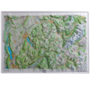
Dorrigo 3D Map Of France

This raised relief map of France is manufactured by Dorrigo and provides a unique overview of the whole country, including the Alps and Pyrenees mountain ranges. The simplified mapping shows key physical features, including the mountain ranges with spot heights of peaks. All main roads, rivers, towns, cities and regions are also clearly shown. This 3D map of France also shows parts of the surrounding countries of Spain, Belgium and Germany. It's ideal for fans of summer or winter sports.
  • Click to be directed to retailers website:

    Buy

    Many items on our site can also be found here:

    Buy
    • External links may include paid for promotion
    Availability: In Stock
    £175.50

    Product Description

    This raised relief map of France is manufactured by Dorrigo & provides a unique overview of the whole country, including the Alps & Pyrenees mountain ranges. The simplified mapping shows key physical features, including the mountain ranges with spot heights of peaks. All main roads, rivers, towns, cities & regions are also clearly shown. This 3D map of France also shows parts of the surrounding countries of Spain, Belgium & Germany. It's ideal for fans of summer or winter sports.

    Reviews/Comments

    Add New

    Price History

    Vouchers

    No voucher codes found.
    Do you know a voucher code for this product or supplier? Add it to Insights for others to use.

    Facebook

    Jargon Buster

    Summer - The season between Spring and Autumn. Usually the hottest season of the year
    Spain - A country within the EU.
    France - A state situated in Western Europe with several overseas territories.
    Germany - A country in Central Europe.
    Key - A physical or virtual device or code used for opening something
    Physical - Used to describe strength or visual properties of an item
    Winter - The fourth season of a year that comes between Spring and Autumn
    Ideal - Something that satisfies a perfect criteria.

    Supplier Information

    Ordnance Survey
    Navigate your world with confidence with Ordnance Survey (https://shop.ordnancesurvey.co.uk/)! Explore our extensive range of maps, guides, and outdoor gear designed to help you explore the great outdoors with ease. From detailed maps for hiking and cycling to innovative GPS devices, we've got everything you need to plan your next adventure. With our heritage of accuracy and reliability, Ordnance Survey is your trusted companion for exploring the UK's landscapes, whether you're a seasoned explorer or a weekend wanderer. Gear up and discover new horizons with Ordnance Survey today!
    Page Updated: 2024-03-04 13:47:34

    Community Generated Product Tags

    Oh No! The productWIKI community hasn't generated any tags for this product yet!
    Menu