More From Contributor

£6.99
The Cotswolds & Gloucestershire OS Tour map: 1:100, 000 tourist map Format: Folded map Physical

Size:
1270

...
Available
£12.99
The OS Explorer map of the English Lakes, North-Eastern Area, including Penrith, Patterdale, & Caldbeck. This a must-have when visiting the North-Eastern area of the Lakes, whether you're looking to explore the Castle at Penrith or the beautifully green villages of Patterdale & Caldbeck, OL5 has got you covered. The perfect companion for your adventure to Helvellyn, the highest point of the Helvellyn range that makes for an exhilarating walk, roughly 2 miles. Maybe you're hoping to soak up the views at Ullswater — the second larges lake in the Lake District. Our OS Explorer maps are perfect for day-tripping, extensive hikes, & cycling. They come in both standard & Weatherproof Active, so you'll never get caught out in a storm. This map also comes with a free digital download, so you can access it across your devices — making for a more convenient companion. Publication Date: 19/04/2021 ...
Available
£16.99
The OS Explorer map of the English Lakes, North-Eastern Area, including Penrith, Patterdale, & Caldbeck. This a must-have when visiting the North-Eastern area of the Lakes, whether you're looking to explore the Castle at Penrith or the beautifully green villages of Patterdale & Caldbeck, OL5 has got you covered. The perfect companion for your adventure to Helvellyn, the highest point of the Helvellyn range that makes for an exhilarating walk, roughly 2 miles. Maybe you're hoping to soak up the views at Ullswater — the second larges lake in the Lake District. Our OS Explorer maps are perfect for day-tripping, extensive hikes, & cycling. They come in both standard & Weatherproof Active, so you'll never get caught out in a storm. This map also comes with a free digital download, so you can access it across your devices — making for a more convenient companion. Publication Date: 19/04/2021 ...
Available
£12.99
The OS Explorer map of The English Lakes, North Western area, including Keswick, Cockermouth, & Wigton. Explorer OL4 is a must-have when visiting the North-West area of the Lakes. Take in the stunning sights on the Catbells walk, soak up the views at Derwent Water, or climb the sixth-highest peak in England — Skiddaw. There's also the ancient market town of Cockermouth to see, birthplace of poet William Wordsworth. Our OS Explorer maps are perfect for day-tripping, extensive hikes, & cycling. They come in both standard & Weatherproof Active, so you'll never get caught out in a storm. This map also comes with a free digital download, so you can access it across your devices — making for a more convenient companion. Publication Date: 23/04/2021 ...
Available
£16.99
The OS Explorer map of The English Lakes, South-Eastern Area, including Windermere, Kendal, & Silverdale. Displaying the South-Eastern part of the Lake District National Park, OL7 is a must-have when visiting the area. Soak up stunning views at Lake Windermere — the largest natural lake in Engl&, mooch around Kendal — a beautiful Cumbrian market town, or explore Silverdale — your gateway to the Lake District. Other highlights of this map include Ambleside & Grasmere. Our OS Explorer maps are perfect for day-tripping, extensive hikes, & cycling. They come in both standard & Weatherproof Active, so you'll never get caught out in a storm. This map also comes with a free digital download, so you can access it across your devices, making for a convenient companion. Publication Date: 17/05/2021 ...
Available
£16.99
The OS Explorer map of The English Lakes, South-Western Area is a must-have when visiting this area of the Lakes District. Explore the market town of Ulverston — a stunning labyrinth of gorgeous old buildings & cobbled streets. Take on the highest peak in Engl&, Scafell Pike, or check out Coniston Village — a beautiful village that sits at the mouth of Coppermines Valley & Yewdale Beck. Our OS Explorer maps are perfect for day-tripping, extensive hikes, & cycling. They come in both standard & Weatherproof Active, so you'll never get caught out in a storm. This map also comes with a free digital download, so you can access it across your devices — making for a more convenient companion. Publication Date: 17/05/2021 ...
Available
£12.99
Dive on in to The Lizard Explorer map — the ideal companion for exploring The Lizard, Falmouth, & Helston. Trek across Goonhilly Downs, as well as the rest of the Lizard Peninsula. Discover Falmouth, the world's 3rd largest natural harbour. Famous for being the start & finish point for several round the world record breaking voyages, including those of Sir Robin Knox-Johnston & Dame Ellen Mac Arthur. Take a trip to Helston, a beautiful little town with extensive history. The name from the Cornish ' Hen lis' or 'old court', with 'ton' added later to denote a Saxon manor; the Domesday Book refers to ' Henliston' — which serves as the name of a road in Helston. All our Explorer makes come with a free mobile download, making for a convenient companion. Publication Date: 23/11/2020 ...
Available
£16.99
Dive on in to The Lizard Explorer map — the ideal companion for exploring The Lizard, Falmouth, & Helston. Trek across Goonhilly Downs, as well as the rest of the Lizard Peninsula. Discover Falmouth, the world's 3rd largest natural harbour. Famous for being the start & finish point for several round the world record breaking voyages, including those of Sir Robin Knox-Johnston & Dame Ellen Mac Arthur. Take a trip to Helston, a beautiful little town with extensive history. The name from the Cornish ' Hen lis' or 'old court', with 'ton' added later to denote a Saxon manor; the Domesday Book refers to ' Henliston' — which serves as the name of a road in Helston. All our Explorer makes come with a free mobile download, making for a convenient companion. Publication Date: 23/11/2020 ...
Available

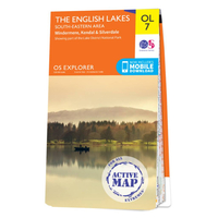
Ordnance Survey Map Of The Lake District: South-eastern Area

The OS Explorer map of The English Lakes, South-Eastern Area, including Windermere, Kendal, & Silverdale.Displaying the South-Eastern part of the Lake District National Park, OL7 is a must-have when visiting the area.Soak up stunning views at Lake Windermere — the largest natural lake in England, mooch around Kendal — a beautiful Cumbrian market town, or explore Silverdale — your gateway to the Lake District.Other highlights of this map include Ambleside and Grasmere.Our OS Explorer maps are perfect for day-tripping, extensive hikes, and cycling. They come in both standard and Weatherproof Active, so you'll never get caught out in a storm. This map also comes with a free digital download, so you can access it across your devices, making for a convenient companion.
Publication Date: 17/05/2021
Availability: In Stock
£12.99

Product Description

The OS Explorer map of The English Lakes, South-Eastern Area, including Windermere, Kendal, & Silverdale. Displaying the South-Eastern part of the Lake District National Park, OL7 is a must-have when visiting the area. Soak up stunning views at Lake Windermere — the largest natural lake in Engl&, mooch around Kendal — a beautiful Cumbrian market town, or explore Silverdale — your gateway to the Lake District. Other highlights of this map include Ambleside & Grasmere. Our OS Explorer maps are perfect for day-tripping, extensive hikes, & cycling. They come in both standard & Weatherproof Active, so you'll never get caught out in a storm. This map also comes with a free digital download, so you can access it across your devices, making for a convenient companion. Publication Date: 17/05/2021

Reviews/Comments

Add New

Price History

Vouchers

No voucher codes found.
Do you know a voucher code for this product or supplier? Add it to Insights for others to use.

Facebook

Jargon Buster

Digital - A system that uses only 0s and 1s to transmit data
Date - A day on a calendar
Date - A social activity whith a current or potential partner
England - A country within the United Kingdom.
Day - The time it takes a planet or other space objects to complete one rotation.
Natural - not manmade
Gateway - Something that tends to be able to walk through usually accompanied by a gate
Convenient - Something that suits and fits well to other activities.

Supplier Information

Ordnance Survey
Navigate your world with confidence with Ordnance Survey (https://shop.ordnancesurvey.co.uk/)! Explore our extensive range of maps, guides, and outdoor gear designed to help you explore the great outdoors with ease. From detailed maps for hiking and cycling to innovative GPS devices, we've got everything you need to plan your next adventure. With our heritage of accuracy and reliability, Ordnance Survey is your trusted companion for exploring the UK's landscapes, whether you're a seasoned explorer or a weekend wanderer. Gear up and discover new horizons with Ordnance Survey today!
Page Updated: 2024-03-04 13:47:34

Community Generated Product Tags

Oh No! The productWIKI community hasn't generated any tags for this product yet!
Menu