More From Contributor
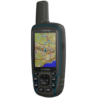
£399.99
The GPSMAP« 64s has all the features of the GPSMAP 64, with the added inclusion of a barometric altimeter, 3-axis compass & wireless connectivity. This bundle

Includes::
Garmin GB Discoverer- 1:50k OS Landranger mapping for the whole of Great Britain.

...
Archived Product
£269.99
The GPSMAP® 64st has all the features of the GPSMAP 64, with the added inclusion of a barometric altimeter, 3-axis compass, wireless connectivity & 8GB internal memory. LAST FEW REMAINING The new GPSMAP 64st handheld navigator features a brilliant 2.6” sunlight-readable screen, a high-sensitivity GPS & GLONASS receiver with a quad helix antenna for faster satellite fix & superior reception. Water resistant & rugged, the GPSMAP 64st comes with barometric altimeter, 3-axis compass, an outdoor optimised dual battery system & a preloaded European REC MAP 100k on 8GB internal memory. It stays connected wirelessly to Garmin sensors via ANT+ & to your smart phone through Bluetooth. The device lasts up to 16 hours on one charge, & the comprehensive features it

Includes::
guarantee safe navigation off the beaten track. Please note that batteries are not included with this unit. Exclusive OS Offer Get a free 12 month OS Maps subscription worth £25.99 with this device. Plan routes, export to GPS & print paper maps at home. A subscription code will be emailed to you within five working days of purchase.

...
Archived Product
£299.99
The GPSMAP® 64sx is the updated version of the GPSMAP 64s. New features include multi-GNSS support including GPS, GLONASS & Galileo, & 8GB of internal memory. Explore the world with reliable navigation in hand with the GPSMAP 64sx featuring a 2.6” sunlight-readable screen & multi-GNSS support (GPS, GLONASS & Galileo) high-sensitivity receiver with a quad helix antenna to track in more challenging environments than GPS alone. Water resistant & rugged, the GPSMAP 64sx comes with barometric altimeter, 3-axis compass, 8GB internal memory with the option to expand storage with a micro SD™ for additional maps & data. Wireless functionality means you can stay connected to Garmin sensors via ANT+ & to your smart phone through Bluetooth The device lasts up to 16 hours on one charge in GPS mode with 2 AA batteries (not included), & the comprehensive features it

Includes::
guarantee safe navigation off the beaten track..

...
Archived Product
£259.99
The GPSMAP® 64x features include multi-GNSS support including GPS, GLONASS & Galileo, & 8GB of internal memory. Explore the world with reliable navigation in hand with the GPSMAP 64x featuring a 2.6” sunlight-readable screen & multi-GNSS support (GPS, GLONASS & Galileo) high-sensitivity receiver with a quad helix antenna to track in more challenging environments than GPS alone. Water resistant & rugged, the GPSMAP 64x comes with 8GB internal memory with the option to expand storage with a micro SD™ for additional maps & data. The device lasts up to 16 hours on one charge in GPS mode with 2 AA batteries (not included), & the comprehensive features it

Includes::
guarantee safe navigation off the beaten track..

...
Archived Product
£234.99
The GPSMAP 64x features include multi-GNSS support including GPS, GLONASS, & Galileo, as well as 8GB internal memory. Explore the world with reliable navigation on a clear 6.6cm (2.6") sunlight readable display. It's water resistant & rugged, to withstand the harshest conditions, & has the capacity for expanded storage via a micro SD. The device lasts up to 16 hours on one charge in GPS mode. ...
Available
£499.99
The Garmin GPSMAP 66i is a multi-activity handheld GPS device & satellite communicator. With the ability to trigger an interactive SOS to GEOS, send & receive two-way messaging & track live locations via the 100% global Iridium satellite network (satellite subscription needed for these features). Confidently navigate with preloaded Topo Active European mapping, direct-to-device Birds Eye Satellite imagery downloads, multi-GNSS support & navigation sensors no matter the outdoor activity. It

Includes::
altimeter, barometer & compass sensors. The altimeter provides elevation data to accurately monitor ascent & descent, while the barometer can be used to predict weather changes by showing short-term trends in air pressure. The three-axis electronic compass shows an accurate bearing whether you're moving or not. You can also link it to a Bluetooth® compatible smartphone to receive Active Weather updates for real-time forecast information, including predictive maps for temperature, wind, precipitation & cloud
- a phone data connection is required. The GPSMAP 66i series offers up to 35 hours of battery life in GPS standard mode & 200 hours in expedition mode. It provides an LED flashlight & SOS beacon that can be used to signal for help. It's built to military standards for thermal, shock & water performance (MIL-STD-810G) & it’s even compatible with night vision goggles. It

Includes::
access to the Garmin Explore mobile app to review & sync data, including waypoints, routes & tracks. You can also import GPX route files created from other mapping applications, such as OS Maps.

Includes::
Garmin GPSMAP 66i with topographic maps Birdseye satellite imagery access code USB (Universal Serial Bus) cable Carabiner clip Documentation GPS 66i handheld requires an active airtime subscription to use Iridium satellite communication features & must be activated at explore. Garmin.com.


...
Archived Product
£359.99
The Garmin GPSMAP 66s is a multi-activity handheld GPS device. Whether you're walking, biking, climbing, geocaching, kayaking or working in outdoor environments, this GPS will help you make the most of your time outdoors. It has a bright 3-inch screen in a robust, waterproof case to cope with whatever the outdoors throws at you. It

Includes::
altimeter, barometer & compass sensors. The altimeter provides elevation data to accurately monitor ascent & descent, while the barometer can be used to predict weather changes by showing short-term trends in air pressure. The three-axis electronic compass shows an accurate bearing whether you're moving or not. You can also link it to a Bluetooth® compatible smartphone to receive Active Weather updates for real-time forecast information, including predictive maps for temperature, wind, precipitation & cloud
- a phone data connection is required. The GPSMAP 66 series offers up to 16 hours of battery life in GPS standard mode & 1 week in expedition mode (with two AA batteries) for fewer charges. It provides an LED flashlight & SOS beacon that can be used to signal for help. It's built to military standards for thermal, shock & water performance (MIL-STD-810G or IPX67). It

Includes::
access to the Garmin Explore mobile app to review & sync data, including waypoints, routes & tracks. You can also import GPX route files created from other mapping applications, such as OS Maps.

Includes::
Garmin GPSMAP 66s Birdseye satellite imagery access code USB (Universal Serial Bus) cable Carabiner clip Documentation


...
Archived Product
£349.99
The GPSMAP 66s is a multi-activity handheld GPS device. Whether you're walking, biking, climbing, geocaching, kayaking, or working outdoors, this GPS will help make the most of your time. It's robust, large display, & waterproof case allow it to be used easily in the worst of conditions. It

Includes::
access to the Garmin Explore mobile app to review & sync data, including waypoints & routes & tracks. You can also import GPX route files created from other mapping applications, such as OS Maps.

...
Available
£449.99
The GPSMAP 66sr is a multi-activity handheld GPS device. Whether you’re walking, climbing, geocaching, kayaking, hunting, or mountain biking, this GPS will help make the most of your time outdoors. It's robust, large display, & waterproof case allow you to easily navigate in the worst of conditions. It

Includes::
access to the Garmin Explore mobile app to review & sync data, including waypoints & routes & tracks. It also comes with a free Garmin 1:50k Full Country SD Card that will automatically be applied to your order at checkout.

...
Available
£399.99
The Garmin GPSMAP 66st is a multi-activity handheld GPS device. The 'st' version adds European topographic maps pre-installed in the device. Whether you're walking, biking, climbing, geocaching, kayaking or working in outdoor environments, this GPS will help you make the most of your time outdoors. It has a bright 3-inch screen in a robust, waterproof case to cope with whatever the outdoors throws at you. It

Includes::
altimeter, barometer & compass sensors. The altimeter provides elevation data to accurately monitor ascent & descent, while the barometer can be used to predict weather changes by showing short-term trends in air pressure. The three-axis electronic compass shows an accurate bearing whether you're moving or not. You can also link it to a Bluetooth® compatible smartphone to receive Active Weather updates for real-time forecast information, including predictive maps for temperature, wind, precipitation & cloud
- a phone data connection is required. The GPSMAP 66 series offers up to 16 hours of battery life in GPS standard mode & 1 week in expedition mode (with two AA batteries) for fewer charges. It provides an LED flashlight & SOS beacon that can be used to signal for help. It's built to military standards for thermal, shock & water performance (MIL-STD-810G or IPX67). It

Includes::
access to the Garmin Explore mobile app to review & sync data, including waypoints, routes & tracks. You can also import GPX route files created from other mapping applications, such as OS Maps.

Includes::
Garmin GPSMAP 66st with topographic maps Birdseye satellite imagery access code USB (Universal Serial Bus) cable Carabiner clip Documentation


...
Archived Product

Garmin Gpsmap 65s

Pay in 3 interest-free payments - select PayPal in checkout. 18+, terms apply. Learn more. A reliable and easy to use multi-band, multi-GNSS handheld GPS with great tracking accuracy, the Garmin GPSMAP 65s is the ideal handheld GPS device to accompany you on your next trip. Feature packed and easy to use, you can use this great navigation device to quickly access the information you need, whatever your outdoor activity. With detailed maps and using a screen that is easy to see in sunlight or poor weather conditions, it doesn’t matter if you are walking, trekking, climbing, cycling, geocaching or out on the water - when you are outdoors this hardy little device will help you find your way.
Availability: In Stock
£314.99

Product Description

Pay in 3 interest-free payments
- select Pay Pal in checkout. 18+, terms apply. Learn more. A reliable & easy to use multi-b&, multi-GNSS handheld GPS with great tracking accuracy, the Garmin GPSMAP 65s is the ideal handheld GPS device to accompany you on your next trip. Feature packed & easy to use, you can use this great navigation device to quickly access the information you need, whatever your outdoor activity. With detailed maps & using a screen that is easy to see in sunlight or poor weather conditions, it doesn’t matter if you are walking, trekking, climbing, cycling, geocaching or out on the water
- when you are outdoors this hardy little device will help you find your way.

Reviews/Comments

Add New

Price History

Vouchers

No voucher codes found.
Do you know a voucher code for this product or supplier? Add it to Insights for others to use.

Facebook

Jargon Buster

GPS - Global Positioning System - Global position using satellites
water - A chemical substance. Chemical formula H2O.
Weather - is the change of an atmospheres conditions.
Reliable - Something that is consistently good and can be trusted.
Feature - An attribute that makes something stand out.
Ideal - Something that satisfies a perfect criteria.

Supplier Information

Ordnance Survey
Navigate your world with confidence with Ordnance Survey (https://shop.ordnancesurvey.co.uk/)! Explore our extensive range of maps, guides, and outdoor gear designed to help you explore the great outdoors with ease. From detailed maps for hiking and cycling to innovative GPS devices, we've got everything you need to plan your next adventure. With our heritage of accuracy and reliability, Ordnance Survey is your trusted companion for exploring the UK's landscapes, whether you're a seasoned explorer or a weekend wanderer. Gear up and discover new horizons with Ordnance Survey today!
Page Updated: 2024-03-04 13:47:34

Community Generated Product Tags

Oh No! The productWIKI community hasn't generated any tags for this product yet!
Menu