More From Contributor

£3.99
Explore Secret Stories Dorchester: Rebels & Writers Tour, a self-guided interactive walking tour to enjoy whenever you want. Shiver at stories of the notorious Hanging Judge & his tough-on-crime approach. Meet the farmworkers who stood up for their rights, got transported to Australia, & accidentally started the trade union movement. Get to know the Romans who built Dorchester & see how they lived at the best-preserved Roman town house in Britain. & meet Dorset's two most famous writers & get to grips with Dorset dialect. Total length: 1.8 miles; Suggested age range: 4+ Purchase this Tour (and more) in the Secret Stories App, available for free download from Android Play & Apple App store. You'll find more details of the tour & what it contains in the app! ...
Available
£14.99
This map is unique. Printed using Ordnance Survey 1:50, 000 mapping this map will bring the landscape to life. Beautifully presented in a printed window box. Due to the size of these products they will be sent by courier only. Please add to cart & review the price for delivery to your address in the checkout. ...
Archived Product
£14.99
This map is unique. Printed using Ordnance Survey 1:50, 000 mapping this map will bring the landscape to life. Beautifully presented in a printed window box. Physical

Size:
Size 31 x 22.5cm Scale 1:50 000 Due to the size of these products they will be sent by courier only. Please add to cart & review the price for delivery to your address in the checkout.

...
Archived Product
£14.99
This map is unique. Printed using Ordnance Survey 1:50, 000 mapping this map will bring the landscape to life. Beautifully presented in a printed window box. Physical

Size:
A4 Scale 1:50 000 Map presentation box measures approximately: H 23.5 x W 33 x D 3.2 cm Map measures approximately*: H 23 x W 32 x D 2 cm * All measurements are approximate.

...
Available
£14.99
This map is unique. Printed using Ordnance Survey 1:50, 000 mapping this map will bring the landscape to life. Beautifully presented in a printed window box. Physical

Size:
Size 31 x 22.5cm Scale 1:50 000 Due to the size of these products they will be sent by courier only. Please add to cart & review the price for delivery to your address in the checkout.

...
Archived Product
£14.99
This map is unique. Printed using Ordnance Survey 1:50, 000 mapping this map will bring the landscape to life. Beautifully presented in a printed window box. Due to the size of these products they will be sent by courier only. Please add to cart & review the price for delivery to your address in the checkout. Map presentation box measures approximately: H 23.5 x W 33 x D 3.2 cm Map measures approximately*: H 23 x W 32 x D 2 cm * All measurements are approximate. ...
Available
£59.99
This 3D relief map is printed on carefully moulded plastic to show the relief on Europe's highest mountain range. Ideal for for display or teaching, it shows the detailed topography of the Alps, & shows the key geographic features, including mountains, roads, cities & larger towns. This map is at 1:1 000 000 scale, & is 95cm x 65cm. It come with a choice of framing options: Unframed
- basic map with no mount or framing Dark frame
- mounted with a solid wood dark oak style frame Light frame
- mounted with a solid wood antique pine style frame Due to the size of these products they will be sent by courier only. Please add to cart & review the price for delivery to your address in the checkout.


...
Archived Product
£99.99
This 3D relief map is printed on carefully moulded plastic to show the relief on Europe's highest mountain range. Ideal for for display or teaching, it shows the detailed topography of the Alps, & shows the key geographic features, including mountains, roads, cities & larger towns. This map is at 1:1 000 000 scale, & is 95cm x 65cm. It come with a choice of framing options: Unframed
- basic map with no mount or framing Dark frame
- mounted with a solid wood dark oak style frame Light frame
- mounted with a solid wood antique pine style frame Due to the size of these products they will be sent by courier only. Please add to cart & review the price for delivery to your address in the checkout.


...
Archived Product
£53.99
These 3D relief maps are great for display or teaching, showing the detailed topography of the Ben Nevis & Glen Coe area printed on a custom moulded 3D plastic base. These maps are at 1:50, 000 scale, & are 675mm x 760mm. They come in a choice of framing options: Unframed
- basic map with no mount or framing Mounted
- comes with a back mount ready to add your own frame Dark frame
- solid wood dark oak style frame Light frame
- solid wood antique pine style frame Due to the size of these products they will be sent by courier only. Please add to cart & review the price for delivery to your address in the checkout.


...
Archived Product

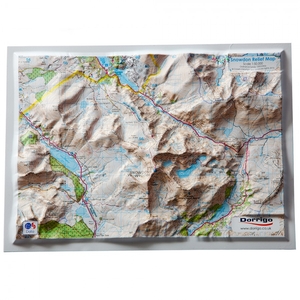
Dorrigo 3D A4 Snowdon Summit Relief Map

This map is unique. Printed using Ordnance Survey 1:50, 000 mapping this map will bring the landscape to life. Beautifully presented in a printed window box. Due to the size of these products they will be sent by courier only. Please add to cart and review the price for delivery to your address in the checkout.
RIP - This product is no longer available on our network. It was last seen on 14.11.2020

This page now acts as a permanent archive for this product. Add more information using the comments box below to ensure it can still be found by future generations.

Use our search facility to see if it is available from an alternative contributor.
Availability: In Stock
£14.99

Product Description

This map is unique. Printed using Ordnance Survey 1:50, 000 mapping this map will bring the landscape to life. Beautifully presented in a printed window box. Due to the size of these products they will be sent by courier only. Please add to cart & review the price for delivery to your address in the checkout.

Reviews/Comments

Add New

Price History

Vouchers

No voucher codes found.
Do you know a voucher code for this product or supplier? Add it to Insights for others to use.

Facebook

Jargon Buster

delivery - The method by which something is delivered from one location to another
Size - is the measurement of how big an object is in space.

Supplier Information

Ordnance Survey
Navigate your world with confidence with Ordnance Survey (https://shop.ordnancesurvey.co.uk/)! Explore our extensive range of maps, guides, and outdoor gear designed to help you explore the great outdoors with ease. From detailed maps for hiking and cycling to innovative GPS devices, we've got everything you need to plan your next adventure. With our heritage of accuracy and reliability, Ordnance Survey is your trusted companion for exploring the UK's landscapes, whether you're a seasoned explorer or a weekend wanderer. Gear up and discover new horizons with Ordnance Survey today!
Page Updated: 2024-03-04 13:47:34

Community Generated Product Tags

Oh No! The productWIKI community hasn't generated any tags for this product yet!
Menu