More From Contributor

£109.68
Giant Garden Games: Wooden See-Saw T Designed to offer years of use, this sturdy wooden see-saw will give hours of fun for your children. At either end of the 3m long main beam are two shaped seats made from waterproof material. The ash handles offer a feeling of security & comfort when holding on. Some drilling required. ...
Archived Product
£92.40
Giant Garden Games: Wooden Square Sandpit (1.2m Diameter) Without a doubt, the most popular piece of play equipment enjoyed by all young children is a sandpit. At 1.2m (4ft) square, this sandpit is big enough to share but small enough not to take over the garden. The built-in cover folds open to provide two simple bench seats, removing the need for a separate lid or cover,

Includes::
geo textile underlay. Some drilling required

...
Archived Product
£85.20
Gardern Games Sandford Family Croquet Set Product Details Here at Garden Games we have always looked to add value to our ...
Archived Product
£304.00
Garmin 62SC GPS Map Worldwide with Camera Description: When the terrain gets tough, you can depend on the GPSMAP 62sc handheld navigator to guide you, with 3-axis tilt-compensated compass, barometric altimeter & a 5 megapixel autofocus camera with photo navigation. Inspired by the powerful GPSMAP 60 series, this rugged & waterproof GPS combines high-precision accuracy with high functionality to brave the demands of any terrain you dare to tackle wherever the adventure, whatever the activity. Explore & take Geotagged Pictures GPSMAP 62sc features a 2.6-inch sunlight-readable colour screen with built-in worldwide basemap with shaded relief, so you can navigate anywhere with ease. You can also capture locations & memories with the 5-megapixel autofocus digital camera. Each photo is automatically geotagged with the location of where it was taken, allowing you to navigate back to that exact spot in the future. To keep track of your photos & show their location on a map, simply use Garmins free Base Camp software. Alternatively you can download pictures from Garmin Connect Photos & navigate to them. Get Your Bearings GPSMAP 62sc has a built-in 3-axis tilt-compensated electronic compass, which helps you get your orientation & points you towards your destination even when you are standing still, without holding it level. Its barometric altimeter tracks changes in pressure to pinpoint your precise altitude. View elevation & profile on the altimeter screen & you can even plot barometric pressure over time to keep an eye on changing weather conditions. Share Wirelessly With GPSMAP 62sc you can share your waypoints, tracks, routes & geocaches wirelessly with other compatible Garmin GPS handhelds. So now your friends can also enjoy your favourite hike or cache, simply press send to transfer your information to similar units, & let the games begin. Keep Your Fix With a quad helix antenna & high-sensitivity, WAAS/EGNOS-enabled GPS receiver with Hot Fix satellite prediction, GPSMAP 62sc has unparalleled reception to locate your position quickly & precisely & maintains its GPS location even in heavy cover & deep valleys. The advantage is clear whether you are in deep woods or just near tall buildings & trees, you can count on GPSMAP 62sc to help you find your way when you need it the most. Enhance Your Adventures With space to store up to 2000 waypoints & 200 routes, GPSMAP 62sc s detailed route planning & tracking helps you navigate from point-to-point & keep track of your journey as you go. As you navigate to a destination on an active track, you can view upcoming elevation changes together with waypoints & key stages along the route for a clear picture of the journey ahead. & with customisable display, you can tailor GPSMAP 62sc s dashboard to show you the details you need on your adventure. Add Maps Adding more maps is easy with Garmin's wide array of detailed topographic, marine & road maps. You can conveniently plug in Garmin GB Discoverer mapping for OS Explorer (1:25k) & OS Landranger (1:50k) detail on your handheld. Search, select & navigate to points of interest & street addresses & follow the route on foot, in the car with turn-by-turn routing or by bike with an Ordnance Survey backdrop. Add Blue Chart g 2 preloaded cards for a great day on the water or City Navigator NT map data for routing on roads in the UK & further afield (see maps tab for compatible maps). Or download customised sections of premium raster-based maps onto your device with Birds Eye Select & integrate them with your maps. In addition, the 62sc is compatible with Custom Maps, free software that transforms paper & electronic maps into downloadable maps for your device. Put your favourite paper or digital maps on GPSMAP 62sc by converting details, labels & landmarks from other maps & informal plans like ski piste routes, mountain bike trails or charity treks into tailored content that is ready to navigate. Plan your route, Survey the terrain, & geotag photos on your computer, then load the data to your outdoor device with our free downloadable software Base Camp. Get Connected You've been busy exploring & now you want to store, save & share your routes, tracks & waypoints. With a simple connection to your computer & to the Internet, you can get a detailed analysis of your activities & send tracks to your outdoor device using Garmin Connect. Simply upload activities saved on GPSMAP 62sc from your hiking, camping or geocaching adventure to keep a record on the web or swap ideas & expeditions with others. This one-stop site offers an activity table & means that you can view your activities on a map using Google Earth. Explore other routes uploaded by millions of Garmin Connect users & share your experiences on Twitter & Facebook. Getting started is easy, so get out there, explore, share & take your adventures further. Find Fun GPSMAP 62sc supports geocaching GPX files to download geocaches & details straight to your unit. Visit Open Caching.com to start your geocaching adventure.GPSMAP 62sc: Take it to the extreme Garmin GPS Map 62SC Worldwide 010-00868-20
Features: * Automatic routing (turn by turn routing on roads) (with optional mapping for detailed roads) * Electronic compass (tilt-compensated, 3-axis) * Barometric altimeter Geocaching-friendly (paperless) * Camera (5 megapixel with autofocus automatic geo-tagging) * Custom maps compatible * Photo navigation (navigate to geotagged photos) * Hunt/fish calendar * Sun & moon information * Tide tables (with optional Bluechart) * Area calculation * Custom POIs (ability to add additional points of interest) * Unit-to-unit transfer (shares data wirelessly with similar units) * Picture viewer * Garmin Connect compatible (online community where you analyze, categorize & share data) * Garmin Basecamp Compatible Specifications: Physical & Performance * Unit

Dimensions, Wx Hx D
- 2.4" x 6.3" x 1.4" (6.1 x 16.0 x 3.6 cm) * Display size, Wx H
- 1.43" x 2.15" (3.6 x 5.5 cm) 2.6" diag (6.6 cm) * Display resolution, Wx H
- 160 x 240 pixels * Display type
- transflective, 65-K colour TFT * Weight
- 9.2 oz (260.1 g) with batteries * Battery
- 2 AA batteries (not included) Ni MH or Lithium recommended * Battery life
- 16 hours * Waterproof
- yes (IPX7) * High-sensitivity receiver
- yes * Interface
- high-speed USB (Universal Serial Bus) & NMEA 0183 compatible Maps & Memory * Basemap * Ability to add maps * Built-in memory
- 1.7 GB * Accepts data cards
- micro SD card (not included) * Waypoints/favorites/locations
- 2000 * Routes
- 200 * Track log
- 10, 000 points, 200 saved tracks


...
Archived Product
£27.97
Garmin Bike Mount for Montana Description: Take your Montana anywhere & everywhere with this handlebar mount. Simply snap your device, in any orientation, portrait or landscape, into the 22 to 32 mm rugged mount, which attaches to any standard bicycle handlebar, & it is ready for your next cycling tour or mountain biking adventure.A molded rubber cushion is included in the kit to increase the mount's grip on the handlebar & also to prevent rotation during possible vibration. Kit also

Includes::
hardware & instructions.

...
Archived Product
£18.99
Garmin Birds Eye Select Retail Card Description: Enhance your next adventure in Great Britain by choosing tailored extracts of Ordnance Survey maps for your Garmin handheld. Using Garmins free application, Base Camp (version 3.1 or later), simply select custom sections of our bespoke Birds Eye Select raster imagery & transfer it straight to your GPS.A single purchase means that you can choose up to 600 sq km of coverage throughout Great Britain. Whether you are heading off on holiday or embarking upon a series of expeditions, you can define the data you need for your exact destinations & navigate with Ordnance Survey raster mapping to a scale of 1:25, 000. Our Birds Eye Select database contains high-resolution Ordnance Survey images for a true representation of your surroundings. Birds Eye Select works with your Garmin handheld maps to add real-world detail to roads, buildings & the terrain for a greater appreciation of your environment. Garmin Birdseye Select Retail Card 010-11758-00 Specifications: * Detailed 1:25, 000 scale raster Ordnance Survey maps give a new level of detail for your onboard maps specifically where you need it
- whether a campsite, remote retreat or extreme sports event. * Comprehensive coverage available, including Engl&, Scotland & Wales (OSGB data). * Choose customized selections of raster maps & transfer to your Garmin handheld device. *A single purchase

Includes::
600 sq km of coverage for your chosen area in Great Britain (Additional quantities can be purchased if coverage needed exceeds the initial size of 600 sq km). * Layer Birds Eye Select over other Garmin vector maps to enhance features, such as roads, buildings & terrain contours in your chosen area. * Provides precision detail for the swift identification of parking areas, clearings for camping, trails & water sources plus terrain type & land use. * Displays the familiar Ordnance Survey Explorer Map detail, including trails, footpaths, view points, natural reserves, firing ranges, point of interest symbols, spot heights, contour detail & more. * Base Camp software (version 3.1 or later) must be installed on the computer (PC or Mac) in order to select & transfer the map data.


...
Archived Product
£18.99
Garmin Chirp Geocaching Beacon chirp is a one-of-a-kind wireless beacon designed specifically for the outdoor adventures of geocaching. Affordable, durable & waterproof, chirp can communicate with, & be programmed by, any compatible wireless-enabled Garmin handheld (sold separately). chirp stores hints, multicache coordinates, counts visitors & confirms the cache is nearby. chirp is password protected & has a battery life of up to one year. Get & Store Hints chirp can be programmed by any compatible wireless-enabled Garmin handheld to store geocaching hints & other information. When other geocachers arrive near your cache, they'll be alerted that the cache is nearby, & then they'll be able to access the hints you've loaded into chirp. & when you return, chirp will tell you how many visitors have been to your cache Set Up a Multicache With chirp, setting up & maintaining a multicache has never been easier. Using your compatible Garmin handheld device, chirp automatically transmits the coordinates so other cachers can find each stage of your multicache. Or if you're on a multicache, chirp lets you download coordinates. So there's no need to manually enter numerous sets of complex coordinates
- there's just one simple touch & you're on your way to the next stage. Built To Cache
- Built to Last chirp was designed by geocachers, so it's built to take the rigours of the outdoors. Plus, chirp is password protected, so you're the only one with programming powers. chirp has a battery life of up to a year & the battery is easy to replace, plus chirp features a cache-perfect, small size & is durable & waterproof. Specifications: Unit

Dimensions, Wx Hx D: 1.3" x 0.9" x 0.3" (3.3 x 2.3 x 0.7 cm) Weight: less than 1.0 oz (28 grams) Waterproof: yes (IPX7
- 1 metre for 30 minutes) Battery: up to 1 year with continuous product use user replaceable battery message appears on your compatible Garmin device when battery is low Range: up to 32 feet (10 metres) Password protection: yes


...
Archived Product

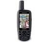
Garmin 62STC GPS Map Worldwide With Camera And Europe Topo (62STC)

Garmin 62STC GPS Map Worldwide with Camera and Europe Topo Description: When the terrain gets tough, you can depend on the GPSMAP 62sct handheld navigator to guide you, with 3-axis tilt-compensated compass, barometric altimeter and a 5 megapixel autofocus camera with photo navigation. Inspired by the powerful GPSMAP 60 series, this rugged and waterproof GPS combines high-precision accuracy with high functionality to brave the demands of any terrain you dare to tackle wherever the adventure, whatever the activity. Explore The TerrainGPSMAP 62st comes with built-in European 1:100k recreation maps with street-level detail and a worldwide basemap with shaded relief - ideal tools for serious climbing or hiking. Map detail includes national and local parks and forests, along with terrain
contours, elevation information, trails, rivers, lakes and points of interest. It has a 2.6-inch sunlight-readable colour screen and supports photo navigation, so you can download pictures from Garmin Connec Photos and navigate to them.Take Geotagged PicturesGPSMAP 62sct features a 2.6-inch sunlight-readable colour screen with built-in worldwide basemap with shaded relief, so you can navigate anywhere with ease. You can also capture locations and memories with the 5-megapixel autofocus digital camera. Each photo is automatically geotagged with the location of where it was taken, allowing you to navigate back to that exact spot in the future. To keep track of your photos and show their location on a map, simply use Garmins free BaseCamp software. Alternatively you can download
pictures from Garmin Connect Photos and navigate to them.Get Your BearingsGPSMAP 62sct has a built-in 3-axis tilt-compensated electronic compass, which helps you get your orientation and points you towards your destination even when you are standing still, without holding it level. Its barometric altimeter tracks changes in pressure to pinpoint your precise altitude. View elevation and profile on the altimeter screen and you can even plot barometric pressure over time to keep an eye on changing weather conditions. Share WirelesslyWith GPSMAP 62sct you can share your waypoints, tracks, routes and geocaches wirelessly with other compatible Garmin GPS handhelds. So now your friends can also enjoy your favourite hike or cache, simply press send to transfer your information to similar
units, and let the games begin. Keep Your FixWith a quad helix antenna and high-sensitivity, WAAS/EGNOS-enabled GPS receiver with HotFix satellite prediction, GPSMAP 62sct has unparalleled reception to locate your position quickly and precisely and maintains its GPS location even in heavy cover and deep valleys. The advantage is clear whether you are in deep woods or just near tall buildings and trees, you can count on GPSMAP 62sct to help you find your way when you need it the most. Enhance Your AdventuresWith space to store up to 2000 waypoints and 200 routes, GPSMAP 62sct's detailed route planning and tracking helps you navigate from point-to-point and keep track of your journey as you go. As you navigate to a destination on an active track, you can view upcoming elevation changes
together with waypoints and key stages along the route for a clear picture of the journey ahead. And with customisable display, you can tailor GPSMAP 62sct's dashboard to show you the details you need on your adventure. Add MapsAdding more maps is easy with Garmin's wide array of detailed topographic, marine and road maps. You can conveniently plug in Garmin GB Discoverer mapping for OS Explorer (1:25k) and OS Landranger (1:50k) detail on your handheld. Search, select and navigate to points of interest and street addresses and follow the route on foot, in the car with turn-by-turn routing or by bike with an Ordnance Survey backdrop. Add BlueChart g2 preloaded cards for a great day on the water or City Navigator NT map data for routing on roads in the UK and further afield (see maps tab
for compatible maps). Or download customised sections of premium raster-based maps onto your device with BirdsEye Select and integrate them with your maps. In addition, the 62sct is compatible with Custom Maps, free software that transforms paper and electronic maps into downloadable maps for your device. Put your favourite paper or digital maps on GPSMAP 62sct by converting details, labels and landmarks from other maps and informal plans like ski piste routes, mountain bike trails or charity treks into tailored content that is ready to navigate. Plan your route, Survey the terrain, and geotag photos on your computer, then load the data to your outdoor device with our free downloadable software BaseCamp. Get ConnectedYou've been busy exploring and now you want to store, save and
share your routes, tracks and waypoints. With a simple connection to your computer and to the Internet, you can get a detailed analysis of your activities and send tracks to your outdoor device using Garmin Connect. Simply upload activities saved on GPSMAP 62sct from your hiking, camping or geocaching adventure to keep a record on the web or swap ideas and expeditions with others. This one-stop site offers an activity table and allows you to view your activities on a map using Google Earth. Explore other routes uploaded by millions of Garmin Connect users and share your experiences on Twitter and Facebook. Getting started is easy, so get out there, explore, share and take your adventures further. Find FunGPSMAP 62sct supports geocaching GPX files to download geocaches and details
straight to your unit. Visit OpenCaching.com to start your geocaching adventure. Features: *Automatic routing (turn by turn routing on roads)(with optional mapping for detailed roads) *Electronic compass (tilt-compensated, 3-axis) *Barometric altimeter *Camera (5 megapixel with autofocus automatic geo-tagging) *Geocaching-friendly (paperless) *Custom maps compatible *Photo navigation (navigate to geotagged photos) *Hunt/fish calendar *Sun and moon information *Tide tables (with optional Bluechart) *Area calculation *Custom POIs (ability to add additional points of interest) *Unit-to-unit transfer (shares data wirelessly with similar units) *Picture viewer *Garmin Connect compatible (online community where you analyze, categorize and share data)Garmin Basecamp Compatible
(free desktop software to plan and review your activities) Specifications: Physical and Performance *Unit dimensions, WxHxD - 2.4in 6.3in x 1.4in (6.1 x 16.0 x 3.6 cm) *Display size, WxH - 1.43in x 2.15in (3.6 x 5.5 cm) 2.6in diag (6.6 cm) *Display resolution, WxH - 160 x 240 pixels *Display type - transflective, 65-K colour TFT *Weight - 9.3 oz (262.1 g) with batteries *Battery - 2 AA NiMH batteries (included) *Battery life - 16 hours (2 AA batteries) *Waterproof - yes (IPX7) *High-sensitivity receiver *Interface - high-speed USB and NMEA 0183 compatible Maps and Memory *Preloaded maps (topographic) *Ability to add maps *Built-in memory - 3.5 GB *Accepts data cards - microSD card (not included) *Waypoints/favorites/locations - 2000 *Routes - 200 *Track log - 10,
000 points, 200 saved tracks
RIP - This product is no longer available on our network. It was last seen on 26.10.2016

This page now acts as a permanent archive for this product. Add more information using the comments box below to ensure it can still be found by future generations.

Use our search facility to see if it is available from an alternative contributor.
  • Availability: Out Of Stock
  • Supplier: All Outdoor
  • SKU: 22945
Availability: In Stock
£341.99

Product Description

Garmin 62STC GPS Map Worldwide with Camera & Europe Topo Description: When the terrain gets tough, you can depend on the GPSMAP 62sct handheld navigator to guide you, with 3-axis tilt-compensated compass, barometric altimeter & a 5 megapixel autofocus camera with photo navigation. Inspired by the powerful GPSMAP 60 series, this rugged & waterproof GPS combines high-precision accuracy with high functionality to brave the demands of any terrain you dare to tackle wherever the adventure, whatever the activity. Explore The Terrain GPSMAP 62st comes with built-in European 1:100k recreation maps with street-level detail & a worldwide basemap with shaded relief
- ideal tools for serious climbing or hiking. Map detail

Includes::
national & local parks & forests, along with terrain contours, elevation information, trails, rivers, lakes & points of interest. It has a 2.6-inch sunlight-readable colour screen & supports photo navigation, so you can download pictures from Garmin Connec Photos & navigate to them. Take Geotagged Pictures GPSMAP 62sct features a 2.6-inch sunlight-readable colour screen with built-in worldwide basemap with shaded relief, so you can navigate anywhere with ease. You can also capture locations & memories with the 5-megapixel autofocus digital camera. Each photo is automatically geotagged with the location of where it was taken, allowing you to navigate back to that exact spot in the future. To keep track of your photos & show their location on a map, simply use Garmins free Base Camp software. Alternatively you can download pictures from Garmin Connect Photos & navigate to them. Get Your Bearings GPSMAP 62sct has a built-in 3-axis tilt-compensated electronic compass, which helps you get your orientation & points you towards your destination even when you are standing still, without holding it level. Its barometric altimeter tracks changes in pressure to pinpoint your precise altitude. View elevation & profile on the altimeter screen & you can even plot barometric pressure over time to keep an eye on changing weather conditions. Share Wirelessly With GPSMAP 62sct you can share your waypoints, tracks, routes & geocaches wirelessly with other compatible Garmin GPS handhelds. So now your friends can also enjoy your favourite hike or cache, simply press send to transfer your information to similar units, & let the games begin. Keep Your Fix With a quad helix antenna & high-sensitivity, WAAS/EGNOS-enabled GPS receiver with Hot Fix satellite prediction, GPSMAP 62sct has unparalleled reception to locate your position quickly & precisely & maintains its GPS location even in heavy cover & deep valleys. The advantage is clear whether you are in deep woods or just near tall buildings & trees, you can count on GPSMAP 62sct to help you find your way when you need it the most. Enhance Your Adventures With space to store up to 2000 waypoints & 200 routes, GPSMAP 62sct's detailed route planning & tracking helps you navigate from point-to-point & keep track of your journey as you go. As you navigate to a destination on an active track, you can view upcoming elevation changes together with waypoints & key stages along the route for a clear picture of the journey ahead. & with customisable display, you can tailor GPSMAP 62sct's dashboard to show you the details you need on your adventure. Add Maps Adding more maps is easy with Garmin's wide array of detailed topographic, marine & road maps. You can conveniently plug in Garmin GB Discoverer mapping for OS Explorer (1:25k) & OS Landranger (1:50k) detail on your handheld. Search, select & navigate to points of interest & street addresses & follow the route on foot, in the car with turn-by-turn routing or by bike with an Ordnance Survey backdrop. Add Blue Chart g 2 preloaded cards for a great day on the water or City Navigator NT map data for routing on roads in the UK & further afield (see maps tab for compatible maps). Or download customised sections of premium raster-based maps onto your device with Birds Eye Select & integrate them with your maps. In addition, the 62sct is compatible with Custom Maps, free software that transforms paper & electronic maps into downloadable maps for your device. Put your favourite paper or digital maps on GPSMAP 62sct by converting details, labels & landmarks from other maps & informal plans like ski piste routes, mountain bike trails or charity treks into tailored content that is ready to navigate. Plan your route, Survey the terrain, & geotag photos on your computer, then load the data to your outdoor device with our free downloadable software Base Camp. Get Connected You've been busy exploring & now you want to store, save & share your routes, tracks & waypoints. With a simple connection to your computer & to the Internet, you can get a detailed analysis of your activities & send tracks to your outdoor device using Garmin Connect. Simply upload activities saved on GPSMAP 62sct from your hiking, camping or geocaching adventure to keep a record on the web or swap ideas & expeditions with others. This one-stop site offers an activity table & means that you can view your activities on a map using Google Earth. Explore other routes uploaded by millions of Garmin Connect users & share your experiences on Twitter & Facebook. Getting started is easy, so get out there, explore, share & take your adventures further. Find Fun GPSMAP 62sct supports geocaching GPX files to download geocaches & details straight to your unit. Visit Open Caching.com to start your geocaching adventure.
Features: * Automatic routing (turn by turn routing on roads) (with optional mapping for detailed roads) * Electronic compass (tilt-compensated, 3-axis) * Barometric altimeter * Camera (5 megapixel with autofocus automatic geo-tagging) * Geocaching-friendly (paperless) * Custom maps compatible * Photo navigation (navigate to geotagged photos) * Hunt/fish calendar * Sun & moon information * Tide tables (with optional Bluechart) * Area calculation * Custom POIs (ability to add additional points of interest) * Unit-to-unit transfer (shares data wirelessly with similar units) * Picture viewer * Garmin Connect compatible (online community where you analyze, categorize & share data) Garmin Basecamp Compatible (free desktop software to plan & review your activities) Specifications: Physical & Performance * Unit

Dimensions, Wx Hx D
- 2.4in 6.3in x 1.4in (6.1 x 16.0 x 3.6 cm) * Display size, Wx H
- 1.43in x 2.15in (3.6 x 5.5 cm) 2.6in diag (6.6 cm) * Display resolution, Wx H
- 160 x 240 pixels * Display type
- transflective, 65-K colour TFT * Weight
- 9.3 oz (262.1 g) with batteries * Battery
- 2 AA Ni MH batteries (included) * Battery life
- 16 hours (2 AA batteries) * Waterproof
- yes (IPX7) * High-sensitivity receiver * Interface
- high-speed USB (Universal Serial Bus) & NMEA 0183 compatible Maps & Memory * Preloaded maps (topographic) * Ability to add maps * Built-in memory
- 3.5 GB * Accepts data cards
- micro SD card (not included) * Waypoints/favorites/locations
- 2000 * Routes
- 200 * Track log
- 10, 000 points, 200 saved tracks

Reviews/Comments

Add New

Intelligent Comparison

Oooops!
We couldn't find anything!
Perhaps this product's unique.... Or perhaps we are still looking for comparisons!
Click to bump this page and we'll hurry up.

Price History

Oooops!
We couldn't find any historical pricing!

Vouchers

No voucher codes found.
Do you know a voucher code for this product or supplier? Add it to Insights for others to use.

Facebook

Jargon Buster

USB - Universal Serial Bus
GPS - Global Positioning System - Global position using satellites
Paper - A thin sheet mainly used for writing. Available in a variety of colours. Made mainly from wood pulp.
Battery - A device used for the storage of electricity
Inch - Equivalent to approximately 2.5cm
Hiking - An outdoor activity envolving walking in nature
UK - United Kingdom - An island nation in Europe
Calendar - A system for organising dates
Eye - An organ which detects light
Computer - A programmable electronic machine which stores and manipulates data.
Pixels - A single point within an image on a screen
Digital - A system that uses only 0s and 1s to transmit data
Resolution - The number of pixels a device can display
Camera - An electronic device used for taking photographs
Foot - A part of the body at the bottom end of the leg
Foot - or Feet - a measurement equivilent to 30cm
Cm - Centimetres, one centimetre is equal to 10 milimetres
Batteries - Portable Power sources in cell form
water - A chemical substance. Chemical formula H2O.
sun - A star at the centre of the solar system.
Key - A physical or virtual device or code used for opening something
Physical - Used to describe strength or visual properties of an item
Waterproof - Resistant to water, usualy specified by depth in metres
Friends - A close associate or a popular US based sitcom about a group of friends
Car - A machine used for transport which runs on roads
Colour - The categorised spectrum of light visable to humans
heavy - A concept of weight indicating an item may require some effort to lift or move
weight - A measure of the force applied on an object by gravity. Measured metric in grams and kilos or imperial in lbs and oz
speed - A measurement of how fast an object travels between two points
Earth - A planet third from the sun. Similar size to Venus but rich in water and complex life.
Day - The time it takes a planet or other space objects to complete one rotation.
Size - is the measurement of how big an object is in space.
Weather - is the change of an atmospheres conditions.
USB - Universal Serial Bus. A method of connecting a device to a computer
Fish - A creature that lives in water. A fish uses gills to breath unlike mammals
Adventure - an undertaking of an exciting challenge or experience.
Quad - Multiple items, meaning four
Road - a manmade lane or a path that is used to speed up travel.
Reception - An atmosphere from a group of people, a radio sound frequency quality.
Precise - A measurement on the accuracy of something
Altitude - Something that can be quite high in relation to sea or ground level.
Wide - Something with a large width.
Simple - Basic, easy no difficulty in understanding.
Dimensions - The shapes and angles of something or a situation.
Performance - When someone is presenting a form of entertainment, also how well someone is doing within a role.
Memory - A way to describe the way in which the brain can remember things.
Ideal - Something that satisfies a perfect criteria.

Supplier Information

Page Updated: 2015-05-01 04:03:15

Community Generated Product Tags

Oh No! The productWIKI community hasn't generated any tags for this product yet!
Menu