More From Contributor

£9.99
Waterproof & tear-resistant map, with each country on one side accompanied by a small plan of its capital. Dominican Republic is shown at 1:400, 000 with a plan of Santo Domingo, & on the reverse side Haiti at 1:350, 000 with a plan of Port-au-Prince. In each country local administrative boundaries are marked, with names of the provinces. Topography is indicated by altitude colouring (in feet), spot heights & names of hill & mountain ranges. Road network

Includes::
unsurfaced tracks & marks border crossings between the two countries. Railways, ferry routes & local airfields are also shown. Extensive range of symbols marks selected hotels, beaches, sites for various outdoor activities (fishing, diving golf, etc.) viewpoints, places of interest, etc. Latitude & longitude lines are drawn at intervals of 30’. Both countries have separate indexes of place names. An enlargement of Santo Domingo is included.

...
Archived Product
£10.39
Domninican Republic in the Countries, Regions & Cities series from Rough Guides; comprehensively detailed guidebooks specifically designed for independent travellers & serving a range of worldwide destinations. Widely recognised for their free editorial style, Rough Guide authors are allowed to express their personal opinions on a range of subjects. Although sometimes controversial, this editorial stance allows readers to experience more detailed & personal takes on each destination, a feature often more limited in other guidebooks. Cultural & historical nuances are explored in significant depth throughout the text & descriptions on the ambience of individual settings alongside personal recommendations, particularly in cities, are notably prevalent. Each Rough Guide in the Countries, Regions & Cities series has a similar layout. A ...
Archived Product
£6.95
Dominican Republic in the Culture Smart range of pocket-sized guide books; providing detailed information on local customs, culture, etiquette & manners & ensuring that visitors are prepared for a diverse range of social environments. The series covers an extensive number of countries worldwide & are designed both for those working & living abroad, as well as for visitors who do not want to offend, either intentionally or inadvertently. Their aim is to prevent readers from making embarrassing mistakes & feel confident in unfamiliar situations, while preparing them before arrival on what to expect & how to behave. Each guide is arranged thematically, with dedicated individual chapters on land & people, values & attitudes, customs & traditions, making friends, people at home, ‘time-out’, travelling & communicating. There is also a separate chapter for business travelers, with important information on subjects such as business culture, meetings & making appointments. A Further Reading section also offers a list of recommended other history, travel literature & language titles available on the country. ...
Archived Product
£9.50
Dominican Republic & Haiti at 1:450, 000 on an indexed, waterproof & tear-resistant road map with topographic & tourist information, published by Reise Know-How as part of their highly acclaimed World Mapping Project. The map is double-sided to provide the best balance between a good scale & a convenient size sheet. The map divides Hispaniola east/west with a considerable overlap so that each country is presented on one side. The island ...
Archived Product
£11.50
Dominican Republic & Haiti at 1:450, 000 on an indexed, waterproof & tear-resistant road map with topographic & tourist information, published by Reise Know-How as part of their highly acclaimed World Mapping Project. The map is double-sided to provide the best balance between a good scale & a convenient size sheet. The map divides Hispaniola east/west with a considerable overlap so that each country is presented on one side. The island’s topography is presented by altitude colouring with contours & spot heights. Swamps & in the coastal waters coral reef are marked. Internal administrative boundaries are shown with names of the provinces. Road network

Includes::
unsurfaced local roads & tracks, & indicates driving distances on main roads. Industrial of mountain railways & local airfields are also shown. Symbols highlight various places of interest, including national parks & botanical gardens, viewpoints, golf courses, beaches & surfing sites, etc. The map has latitude & longitude grid at intervals of 30’. Each country has a separate index. Map legend

Includes::
English. The map

Includes::
an inset showing the whole of the Caribbean.


...
Archived Product
£7.95
Description of the previous edition: Dominican Republic & Haiti at 1:600, 000 from Nelles Verlag, with an enlargement for the Punta Cana area, plus street plans of Santo Domingo, Puerto Plata, Santiago de los Caballeros & Port-au-Prince. Each country is covered on one side of the map, accompanied by the relevant street plans. Relief shading with spot heights & names of mountain ranges presents the topography. Road network distinguishes between highways in good & poor condition & shows distances on main routes. Local airports are shown & in the Dominican Republic railway lines are included. The map also shows internal administrative boundaries in each country with names of the provinces. Various places of interest are prominently marked, including national parks or other protected areas & beaches. Latitude & longitude margin ticks are at 1 ...
Archived Product
£10.39
Dominican Republic & Haiti in the Countries & Regions series from Lonely Planet, market-leading comprehensive guides aimed at independent travellers & serving a large range of international destinations. Frank & informal in style, the guides explore an extensive range of sights, activities, accommodation, restaurants & nightlife & are designed for practical use while travelling on the road. Written & researched by a team of experts, each book is independent in its recommendations & suggestions, often offering individual takes on individual destinations. Widely recognised for their reliability, each Lonely Planet country & region guide has the same layout. Introductory sections profile the destination with individual chapters on particular highlights, getting started, (including when to go) itineraries, history, culture, arts, food & drink & the environment. Each guide is organised geographically by region, with individual sections detailing an extensive range of sights, places of interest, attractions, restaurants, nightlife, accommodation & any local activities. The guides have detailed explanations of historical context where relevant. There is also practical guidance on ...
Archived Product
£12.99
Discover the Dominican Republic & Haiti
Plunge down the Rio Yaque del Norte, paddling for dear life
Witness the chanting,

...
Archived Product
£9.99
Laminated & waterproof tourist map of the Dominican Republic with street plans of Santo Domingo, Santiago & Puerto Plata. The main map covers the country at 1:600, 000, with relief shading, spot heights & names of various mountain ranges showing its topography. National parks are highlighted & symbols mark locations of various places of interest, including beaches, scuba diving & windsurfing sites, etc. On the reverse there are plans of central Santo Domingo with an enlargement for its old colonial district, Santiago & Puerto Plata, highlighting places of interest & various facilities including selected accommodation. Both the main map & the plans are indexed with lists of localities/streets & places of interest. Also included are enlargements showing the environs of Santo Domingo & Puerto Plata, a distance table for the country’s road network, & climate charts. ...
Archived Product
£7.99
Dominican Republic in the Eyewitness Top 10 series from Dorling Kindersley is a condensed format guide book featuring dozens of illustrated, top ten lists for the traveller regardless of their disposable budget. To save you time & money a Top 10 Things to Avoid is also included. Top 10 lists are given for things to see & do across the Dominican Republic, as well as the top ten features of particular locations or events. Practicalities are not forgotten as Top 10s are also provided for topics such as planning your trip, getting around & shopping. Accommodation lists provide the ten most recommended places to stay for a range of budgets, whilst restaurant top tens feature as the guide works its way through the location in question. Simple, small street plans illustrate the location of the top ten recommends within their neighbourhoods & basic, fold out maps form the inside covers. An additional pull out feature of the guide suggests ideas on how to spend your day & a phrase section is included which will help the traveller to acclimatise. ...
Archived Product

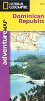
Dominican Republic Adventure Map

Dominican Republic at 1:450, 000 on a waterproof and tear-resistant map from the National Geographic Society, with on the reverse street plans and enlargements for most visited areas, all illustrated with numerous colour photos and descriptions.On one side is a map of the whole country at 1:450, 000. Topography is very effectively presented by contours at 100m intervals with additional altitude shading, spot heights and names of mountain ranges, plus graphics and/or colouring for forested areas, swamps, mangrove and coral reefs in the coastal waters. Road network includes selected tracks and paths, with distances shown on main routes. Crossing points to Haiti are indicated, and domestic airports or airstrips are marked. Also shown are internal administrative boundaries with names
of the provinces.Symbols highlight various places of interest, including surfing, diving and deep sea fishing sights, shipwrecks, golf courses, caves, etc. The map also prominently shows the country’s numerous protected areas, with a separate index listing national parks, forest reserves, natural monuments, national recreation areas, scientific reserves, wildlife refuges and marine mammal sanctuaries. The map has a UTM grid, plus latitude and longitude margin ticks at intervals of 20’. Apart from the protected areas, only a short index of selected towns is provided.On the reverse is an overview plan of Santo Domingo, naming main streets and districts and indicating locations of main sights. A more detailed enlargement shows the Colonial Old City. Also provided are
enlargements showing in greater detail the Samana Peninsula, Lake Enriquillo and environs, Del Este National Park and the Cordillera Central around Pico Duarte, the highest point in the Caribbean.Across both sides of the map are numerous colour photos and descriptions of sights, fauna and flora.
RIP - This product is no longer available on our network. It was last seen on 25.09.2019

This page now acts as a permanent archive for this product. Add more information using the comments box below to ensure it can still be found by future generations.

Use our search facility to see if it is available from an alternative contributor.
  • Availability: Out Of Stock
  • Supplier: Stanfords
  • SKU: 9781566952347
Availability: In Stock
£9.99

Product Description

Dominican Republic at 1:450, 000 on a waterproof & tear-resistant map from the National Geographic Society, with on the reverse street plans & enlargements for most visited areas, all illustrated with numerous colour photos & descriptions. On one side is a map of the whole country at 1:450, 000. Topography is very effectively presented by contours at 100m intervals with additional altitude shading, spot heights & names of mountain ranges, plus graphics and/or colouring for forested areas, swamps, mangrove & coral reefs in the coastal waters. Road network

Includes::
selected tracks & paths, with distances shown on main routes. Crossing points to Haiti are indicated, & domestic airports or airstrips are marked. Also shown are internal administrative boundaries with names of the provinces. Symbols highlight various places of interest, including surfing, diving & deep sea fishing sights, shipwrecks, golf courses, caves, etc. The map also prominently shows the country’s numerous protected areas, with a separate index listing national parks, forest reserves, natural monuments, national recreation areas, scientific reserves, wildlife refuges & marine mammal sanctuaries. The map has a UTM grid, plus latitude & longitude margin ticks at intervals of 20’. Apart from the protected areas, only a short index of selected towns is provided. On the reverse is an overview plan of Santo Domingo, naming main streets & districts & indicating locations of main sights. A more detailed enlargement shows the Colonial Old City. Also provided are enlargements showing in greater detail the Samana Peninsula, Lake Enriquillo & environs, Del Este National Park & the Cordillera Central around Pico Duarte, the highest point in the Caribbean. Across both sides of the map are numerous colour photos & descriptions of sights, fauna & flora.

Reviews/Comments

Add New

Price History

Vouchers

No voucher codes found.
Do you know a voucher code for this product or supplier? Add it to Insights for others to use.

Facebook

Jargon Buster

Forest - A area with a high density of trees
Graphics - A general term for visual aspects of an item/display
Waterproof - Resistant to water, usualy specified by depth in metres
Colour - The categorised spectrum of light visable to humans
Natural - not manmade
Network - A link and communication between things. Often computers or people.
Adventure - an undertaking of an exciting challenge or experience.
Road - a manmade lane or a path that is used to speed up travel.
Resistant - Something that can repel against something.
Caribbean - An area of islands within the Caribbean sea.
Altitude - Something that can be quite high in relation to sea or ground level.
Golf - A sport played on a large outside grass course, the aim to hit a small ball with a club into small holes.

Supplier Information

Stanfords
Stanfords was established in 1853 and opened their iconic Covent Garden flagship store in 1901. They have become the top retailer of maps, travel books and accessories in the UK and arguably offer the largest selection of maps and travel books worldwide. Famous names such as Captain Robert Falcon Scott, Ranulph Fiennes and Michael Palin have purchased from Stanfords. They now have a shop in Bristol and both stores together with other venues operate a calendar of events including talks, book signings and exhibitions. As a specialist map retailer, the map selection is comprehensive and includes road maps, street maps and walking maps from worldwide destinations, as well as a selection of world atlases and wall maps. Books include travel guides and travel literature. Stanfords also stock globes, from miniatures made of blue marble to magnificent floor-standing globes. The website features a selection of interesting articles on travel topics.
Page Updated: 2023-11-12 20:15:36

Community Generated Product Tags

Oh No! The productWIKI community hasn't generated any tags for this product yet!
Menu