More From Contributor
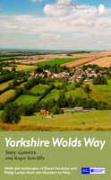
£3.99
Yorkshire is a land of hills & dales, with moors criss-crossed with ancient stone walls & a network of drovers' roads, linking a variety of towns & the medieval city of York. Part of the Souvenir Series, this work is a guide to the towns of Yorkshire. It covers the history & folklore of the region & seeks to answer important questions as to its cultural heritage. ...
Archived Product
£11.95
West Yorkshire Street Atlas from the Geographers` A-Z Map Company in a spiral-bound format slightly smaller than A4 & covering the whole county at 1:19, 000 (3.33” to 1 mile). More detailed mapping at 1:9, 051 (7” to 1 mile) shows town centres of Leeds, Bradford, Halifax, Huddersfield & Wakefield. Current edition of this title was published in 2014. To see other titles in this series of A-Z county street atlases please click on the series link. A-Z also publish street atlases in a smaller A5 paperback format covering towns & cities with their surrounding areas
- for a list of titles in that series please search for SI00000932. Most A-Z county street atlases are in a spiral-bound format just smaller than A4 size, Most titles offer coverage of only the built-up areas, with selected titles covering the whole county
- as indicated in the individual descriptions & our area coverage images. Motorways plus A & B roads are highlighted by colouring & show route numbers. One way or restricted access streets, Park & Ride facilities & selected car parks are marked, as are locations of speed cameras. Also shown are selected cycleway routes. Where appropriate, A & B roads are annotated with selected house numbers for easier identification of addresses. Railway lines are shown with stations & level crossings. Colouring indicates different types of buildings: educational, hospitals & healthcare, industrial, leisure & recreational, shopping centres & markets, public buildings, & places of interest. Symbols mark locations of facilities usually indicated on street mapping: post offices, emergency services, public toilets, etc. Also marked are postcode & local authority boundaries. Each page has the lines & coordinates of the British National Grid. All the titles have a comprehensive index including, unless specified to the contrary in the description, separate entries for places of interest such as cultural & sport or recreational facilities, historical sites, nature reserves & gardens. Many titles include a separate list of hospitals & hospices in the area covered by the atlas.

...
Archived Product
£2.95
Yorkshire West Riding 1610 Replica Map by the Old Map Company is a reproduction of the map created for the famous atlas of the period by the master map maker John Speede Esq. The Old Map Company has recreated the antique maps of British counties, European cities & World countries originally crafted by master map maker John Speede Esq. whose work had accuracy & quality not surpassed for centuries. Each map is treated & presented on specially crafted paper then h&-treated giving it texture & an aged appearance before being beautifully engraved & detailed. ...
Archived Product
£35.00
This authoritative guide, the companion to Yorkshire West Riding: Leeds, Bradford & the North, covers a vast area marked by tremendous diversity of both landscape & buildings. The territory is rich in medieval churches & castles, 17th-century houses & 18th-century mansions, yet it is also deservedly famous for its outstanding 19th- & 20th-century ecclesiastical, civic, commercial & industrial buildings. Major examples of every period of English architecture are represented, from Selby Abbey to the palatial country house of the Earls Fitzwilliam at Wentworth Woodhouse, & from Halifax Town Hall to Sheffield`s Park Hill flats & the Yorkshire Sculpture Park near Wakefield. In the fine Pevsner tradition, this book situates the region`s full array of buildings within geological, local, national, & international contexts. ...
Archived Product
£10.95
West Yorkshire Street Atlas in a spiral-bound edition at a scale of 3? inches to 1 mile (1:19, 000) in a series of street atlases of English counties from the Geographers' A-Z Map Company. The atlas provides coverage of the whole of the metropolitan county, including Castleford, Denby Dale, Garforth, Hebden Bridge, Holmfirth, Ilkley, Keighley, Knottingley, Marsden, Otley, Royston, Silsden, South Elmsall, Todmorden & Wetherby. Enlargements cover, in greater detail, city centres of Leeds, Bradford, Halifax, Huddersfield & Wakefield at a scale of 7 inches to 1 mile (1:9, 051). The atlas has a comprehensive index including separate entries for places of interest such as cultural & sport or recreational facilities, historical sites, nature reserves & gardens. Also provided are lists of hospitals & hospices in the area covered by the atlas. Current edition was published in 2010. ...
Archived Product
£12.99
Yorkshire Wolds Way, a 127-km/79 mile route from Hessel near Hull to Filey, in a series of walking guides to the National Trails in England & Wales with colour extracts from the Ordnance Survey's Explorer series at 1:25, 000 showing points along the route cross-referenced to the text. The maps also indicate nearby places of interest & various facilities including campsites & caravan parks, youth hostels, water points, pubs, information or visitor centres, etc. Also shown are alternative sections of the route & stretches designated as bridleways or suitable for cycling. The guides are illustrated throughout with colour photos & include an introductory section on the path & the surrounding landscape, plus a chapter of useful information including access to various locations along the route by public transport, a list of tourist information offices & principal overnight stopping places, a bibliography, etc. ...
Archived Product
£13.95
The Yorkshire Wolds Way is a 79 mile (127 km) walking route in the chalk landscape of the Yorkshire Wolds. The National Trail wends through some of the most tranquil & gentle countryside in Engl&. From the banks of the mighty Humber estuary, along wooded slopes & through serene dry valleys, the walk climbs gently onto the airy tops of the rolling hills where on a clear day you can see forever. Descending from the northern escarpment the final section of the way finishes on the dramatic headland of Filey Brigg. ...
Archived Product
£14.99
The Yorkshire Wolds were brought to international attention in 2012 by David Hockney's magnificent Royal Academy exhibition of paintings of the region. Now, Tony Gowers' completely updated, expanded & re-designed National Trail Guide offers the essential companion to the forgotten but fascinating landscape through which this Trail runs. The Trail runs from Hessle in the south, by the Humber Bridge, to Filey on the North Yorkshire coast, through the Wolds' secluded & special 'dry valleys', a succession of tranquil villages, & past cel;ebrated locations like Thixendale woods now immortalised in Hockney's vast & dazzling paintings. As well as comprehensive route descriptions accompanied by OS 1:25, 000 maps, the book features a Philip Larkin Trail around Hull, digressions to the handsome town of Beverley with its beautiful Minster, the Holderness region made famous by Winfred Holtby's South Riding, the seabird colony at RSPB Bempton Cliffs, as well as circular walks to all of the principal locations of Hockney's Wolds paintings. The result is a n essential purchase, not just for those walking the Trail, but for every visitor to the area. ...
Archived Product
£7.99
Yorkshire Wolds, York & the Humber Cycle Map at 1:110, 000 approx from Sustrans, including the Yorkshire Wolds Cycle Route, part of the Way of the Roses route, & Trans Pennine Trail East, plus five day rides: Hull to Hornsea Circular, Bridlington & Hunmanby Loop, York to Selby & Stamford Bridge, Malton & the High Wolds, & Beverley & the Newbalds. Street plans show York, Hull, Selby, Beverley & Bridlington. Maps is this Sustrans series show all the National & Regional Cycle Network routes clearly numbered & have the colouring distinguishing between the on-road & traffic-free sections. The publishers’ own recommendations are shown in contrasting colour &, in most titles, are in addition presented on the reverse side on separate panels where each circuit is annotated with useful notes. The maps have contours & altitude colouring to show the topography, with additional gradient markings. Towns along the routes are annotated with symbols indicating what facilities can be found there. Also marked are various places of interest, on or near the routes, & railway lines are shown with stations for access to the routes by rail. On the reverse each title also provides large, clear city centre street plans of main towns, highlighting the Cycle Network and/or the recommended routes. Also included are contact details of tourist information centres. To see the list of titles in this series please click on the series link. ...
Archived Product
£25.00
In YORKSHIRE, Richard Morris looks beyond stereotypes, exploring interactions between landscape, language, & memory. The county is one of Europe`s most geologically varied areas
- a realm where mountain, plain, coast, chalk hills, wetland & heath lie close, often within sight of each other. Morris considers how we discover Yorkshire, whether as modern travellers, through eyes of artists (J. M. W. Turner, William Sawrey Gilpin, William Callow, Henry Moore) or writers` imaginations (Michael Drayton, Winifred Holtby, J.B. Priestley, Ted Hughes). We travel to strange places, like the county`s netherworld of caves, mines & tunnels, & confront dark subjects such as the part played by Whitby & Hull in the emptying of Arctic seas & shores of whales & bears. In contrarian spirit, Morris even finds Robin Hood to have been a Yorkshireman. YORKSHIRE explore the tumultuous history of God`s Own County & asks why it has so often been to the fore in times of conflict or tension (think Wars of the Roses, Northern Rising, Civil War, Cold War, the miners` strike of 1984). Outward-lookingness is a repeating theme. Eighteen centuries ago a province of the Roman Empire was governed from York; in the Viking age a trading axis ran from Dublin through the kingdom of York to the Baltic, along Russian rivers to Byzantium & Baghdad. Both in area & population Yorkshire today is larger than many member countries of the UN, yet remains just an English county. As Richard Morris reveals in this dazzlingly wide-ranging & lyrical history, Yorkshire has always been both a region with a distinct identity inside Britain & a fulcrum in the world.
...
Archived Product

Yorkshire Wolds Way

The Yorkshire Wolds were brought to international attention in 2012 by David Hockney`s magnificent Royal Academy exhibition of paintings of the region. Now, Tony Gowers` completely updated, expanded and re-designed National Trail Guide offers the essential companion to the forgotten but fascinating landscape through which this Trail runs. The Trail runs from Hessle in the south, by the Humber Bridge, to Filey on the North Yorkshire coast, through the Wolds` secluded and special `dry valleys`, a succession of tranquil villages, and past cel;ebrated locations like Thixendale woods now immortalised in Hockney`s vast and dazzling paintings. As well as comprehensive route descriptions accompanied by OS 1:25, 000 maps, the book features a Philip Larkin Trail around Hull, digressions to
the handsome town of Beverley with its beautiful Minster, the Holderness region made famous by Winfred Holtby`s South Riding, the seabird colony at RSPB Bempton Cliffs, as well as circular walks to all of the principal locations of Hockney`s Wolds paintings. The result is a n essential purchase, not just for those walking the Trail, but for every visitor to the area.
RIP - This product is no longer available on our network. It was last seen on 25.09.2019

This page now acts as a permanent archive for this product. Add more information using the comments box below to ensure it can still be found by future generations.

Use our search facility to see if it is available from an alternative contributor.
  • Availability: Out Of Stock
  • Supplier: Stanfords
  • SKU: 9781781315682
Availability: In Stock
£14.99

Product Description

The Yorkshire Wolds were brought to international attention in 2012 by David Hockney`s magnificent Royal Academy exhibition of paintings of the region. Now, Tony Gowers` completely updated, expanded & re-designed National Trail Guide offers the essential companion to the forgotten but fascinating landscape through which this Trail runs. The Trail runs from Hessle in the south, by the Humber Bridge, to Filey on the North Yorkshire coast, through the Wolds` secluded & special `dry valleys`, a succession of tranquil villages, & past cel;ebrated locations like Thixendale woods now immortalised in Hockney`s vast & dazzling paintings. As well as comprehensive route descriptions accompanied by OS 1:25, 000 maps, the book features a Philip Larkin Trail around Hull, digressions to the handsome town of Beverley with its beautiful Minster, the Holderness region made famous by Winfred Holtby`s South Riding, the seabird colony at RSPB Bempton Cliffs, as well as circular walks to all of the principal locations of Hockney`s Wolds paintings. The result is a n essential purchase, not just for those walking the Trail, but for every visitor to the area.

Reviews/Comments

Add New

Intelligent Comparison

Oooops!
We couldn't find anything!
Perhaps this product's unique.... Or perhaps we are still looking for comparisons!
Click to bump this page and we'll hurry up.

Price History

Vouchers

No voucher codes found.
Do you know a voucher code for this product or supplier? Add it to Insights for others to use.

Facebook

Jargon Buster

Dry - A term used to describe an item with has little or no water present
Dry - A term used in wine making to describe the lack of sugar (sweetness)

Supplier Information

Stanfords
Stanfords was established in 1853 and opened their iconic Covent Garden flagship store in 1901. They have become the top retailer of maps, travel books and accessories in the UK and arguably offer the largest selection of maps and travel books worldwide. Famous names such as Captain Robert Falcon Scott, Ranulph Fiennes and Michael Palin have purchased from Stanfords. They now have a shop in Bristol and both stores together with other venues operate a calendar of events including talks, book signings and exhibitions. As a specialist map retailer, the map selection is comprehensive and includes road maps, street maps and walking maps from worldwide destinations, as well as a selection of world atlases and wall maps. Books include travel guides and travel literature. Stanfords also stock globes, from miniatures made of blue marble to magnificent floor-standing globes. The website features a selection of interesting articles on travel topics.
Page Updated: 2023-11-12 20:15:36

Community Generated Product Tags

Oh No! The productWIKI community hasn't generated any tags for this product yet!
Menu