More From Contributor

£11.19
Laminated waterproof edition of a detailed topographic map from the Ordnance Survey Explorer series, covering York, Selby & Tadcaster. Edition A1; Publication date April 2006 About this series: These highly detailed maps show all the administrative boundaries, settlements as small as isolated farms, the road network down to unfenced roads & country tracks, & field boundaries (hedges & drystone walls) which make navigation across the countryside much easier. Steep gradients on roads are indicated. Various landmarks, e.g. powerlines, archaeological sites, windmills, churches & lighthouses are shown & additional graphics indicate natural terrain features such as cliffs, scree, mud & vegetation variations. The contour interval is 5 metres in the lower parts of the country & 10 metres in the uplands, & spot heights are marked. Each map covers an area of 30 x 20km (i.e. approx. 19 x 12 miles), with some double-sided maps covering more, as indicated in the individual descriptions. The maps are fully GPS compatible, with the National Grid shown at 1km intervals & latitude & longitude indicated by margin ticks at 1'. The Explorer series has replaced the earlier, green-cover Pathfinder maps. The Explorer series is now complete & covers all of Engl&, Wales & Scotl&. Some sheets for popular areas like the National Parks are still branded as Outdoor Leisure (OL) maps, but are now included in this series as the cartography is the same as that in the Explorer Maps. The Explorer maps offer a substantial improvement on the Pathfinder series, with greater use of colour, larger area per map, & stronger emphasis on information for ramblers & tourists. This series is ideal for walking & other outdoor pursuits & each map shows a large amount of information for ramblers & tourists. Public rights of way are shown (except in Scotland), together with other routes with public access: National Trails & Recreational Paths, permitted paths & bridleways, & selected cycle routes. Open access land created under the Countryside & Rights of Way Act 2000 is marked. Tourist information

Includes::
caravan & camp sites, Park & Ride locations, recreation/leisure/sport centres, museums, historic buildings, English Heritage & National Trust sites, rural pubs, etc. The map legend is in English only, except for the tourist information content which is also in French & German.

...
Archived Product
£45.00
Geoplan Postcode Sector maps provide high-detail local mapping of the UK overlaid with postcode sectors, country boundaries & larger postcode groupings. They are durable & laminated, so you can draw on them in non-permanent markers & wipe them clean. They are the market-leader postcode maps for marketing, statistical display, route-planning, strategy & many other business uses. The base map uses the latest Ordnance Survey Landranger cartography, which provides detailed geographic data including motorways, A & B roads, streets, & detailed feature types such as airports, railway stations, cities, towns, geographic names, heights (using contour lines), information centres, parking facilities & much more. The base map is light & subtle but clear, readable & now in colour. Postcode/county boundaries & labels are overlaid in a bold red. The Postcode system divides the UK into Areas, Districts & Sectors. Geoplan publish maps covering all of these levels. These Sector maps cover 37 small areas of the UK, showing postcode Sectors (like HG3 1, B10 9, WC2 9 etc), their larger Districts (HG3, B10, WC2 etc) & the even larger Areas (HG, B, WC etc) ...
Archived Product
£9.50
Yorke Peninsula in South Australia on an indexed touring map at 1:350, 000 from Carto Graphics, with on the reverse enlargements showing in greater detail the Innes National Park & Warding Isl&. Coverage extends north to Port Broughton & east to include Adelaide & the coast to the north of the city. On one side is a touring map of the Yorke Peninsula at 1:350, 000 showing the region’s road network & highlighting national parks & other protected areas, Aboriginal Lands, & the restricted entry military zone. Driving distances are marked on main & secondary roads. Symbols indicate tourist information centres, surfing & diving sites, boat ramps, viewpoints, etc. Topography is presented by relief shading. Latitude & longitude lines are drawn at 10’ intervals. The index, next to the map,

Includes::
a list of parks & reserves. Also provided is a distance table. On the reverse enlargements at 1:50, 000 show in greater detail the Innes National Park at the tip of the peninsula, plus the Maritime Heritage Trails around Warding Island (the interior of the island where entry is by permit only does not show any information). Also provided are notes about the area. To see the list of the publisher`s other regional maps of South Australia please click on the series link.

...
Archived Product
£10.39
Yorkshire in the Countries, Regions & Cities series from Rough Guides; comprehensively detailed guidebooks specifically designed for independent travellers & serving a range of worldwide destinations. Widely recognised for their free editorial style, Rough Guide authors are allowed to express their personal opinions on a range of subjects. Although sometimes controversial, this editorial stance allows readers to experience more detailed & personal takes on each destination, a feature often more limited in other guidebooks. Cultural & historical nuances are explored in significant depth throughout the text & descriptions on the ambience of individual settings alongside personal recommendations, particularly in cities, are notably prevalent. Each Rough Guide in the Countries, Regions & Cities series has a similar layout. A ...
Archived Product
£12.99
The largest county in England
- ` God`s Own County` to its inhabitants
- Yorkshire offers the visitor everything from the beauty

...
Archived Product
£24.50
Regional wall map of Yorkshire & Humberside at 1:200, 000 (3.2 miles to 1inch) from A to Z, covering: Appleby-in-Westmorl&, Middlesbrough, Whitby, Kingston Upon Hull, Grimsby, Lincoln, Mansfield, Blackburn, & Kirkby Lonsdale. Clear presentation of the road network shows motorways, A & B roads, some minor & local roads, with gradients of 1:5 & steeper indicated. Service stations, railway lines & stops, ferry terminals, & airports are clearly marked. Tourist information such as points of interest & local facilities are prominently highlighted with a variety of symbols. Topography is shown by altitude tints, if in rather broad bands, with spot heights (in feet) & additional colouring for woodland areas; the National Grid is overprinted on the cartography. National & unitary authority boundaries are indicated. There is an index for cities, town, & villages at the edge of the map. ...
Archived Product
£6.99
Regional wall map of Yorkshire & Humberside at 1:200, 000 (3.2 miles to 1inch) from A to Z, covering: Appleby-in-Westmorl&, Middlesbrough, Whitby, Kingston Upon Hull, Grimsby, Lincoln, Mansfield, Blackburn, & Kirkby Lonsdale. Clear presentation of the road network shows motorways, A & B roads, some minor & local roads, with gradients of 1:5 & steeper indicated. Service stations, railway lines & stops, ferry terminals, & airports are clearly marked. Tourist information such as points of interest & local facilities are prominently highlighted with a variety of symbols. Topography is shown by altitude tints, if in rather broad bands, with spot heights (in feet) & additional colouring for woodland areas; the National Grid is overprinted on the cartography. National & unitary authority boundaries are indicated. There is an index for cities, town, & villages at the edge of the map. ...
Archived Product
£5.00
Folded cycling map of Yorkshire from the National Byway Trust, forming part of their heritage cycling route of Great Britain. One side of the map has AA mapping at 1:187, 500, whilst the reverse has detailed descriptions of this section of the National Byway, including Gainsborough to Humber Bridge & Richmond to Barnard Castle. The map shows the National Byway route & additional loop sections off of the cycleway, with small boxes describing the individual loop rides. Cartography shows motorways, A & B & minor roads, with the routes highlighted prominently. Areas of ...
Archived Product
£2.95
Yorkshire 1610 Replica Map by the Old Map Company is a reproduction of the map created for the famous atlas of the period by the master map maker John Speede Esq. The Old Map Company has recreated the antique maps of British counties, European cities & World countries originally crafted by master map maker John Speede Esq. whose work had accuracy & quality not surpassed for centuries. Each map is treated & presented on specially crafted paper then h&-treated giving it texture & an aged appearance before being beautifully engraved & detailed. ...
Archived Product
£14.99
The three peaks which are part of the Yorkshire Three Peaks Challenge: Pen-y-ghent, Whernside & Ingleborough shown on handy size, waterproof & tear-resistant extracts from the Ordnance Survey 1:25, 000 Explorer series. The three maps are sold together in a presentation wallet which also

Includes::
brief descriptions & spaces for recording your timings for each route. The maps, folded to only 10x 15cm, are centred on the peak, cover an area of 7 x 6.25km (4.2 x 4 miles approx), & have British National Grid lines & coordinates. Each map has its own protective envelope & the route description is provided on a separate, credit card size slip.

...
Archived Product

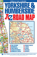
Yorkshire & Humberside A-Z Map

Yorkshire and Humberside on an indexed road map at 1:200, 000 (1” to 3 miles) from A-Z. Coverage extends north to Bishop Auckland, south-west to Manchester and its conurbation, and south to Mansfield and Lincoln. The index is next to the map. Current edition was published in 2015.Mapping in this regional series from A-Z has clear presentation of the road network, topographic information, places of interest, etc. Publishers’ cartography used in their 5 miles to 1” series is enlarged here to make local roads more prominent and provides all the standard motoring information: services, primary route destinations, toll barriers, gradients, locations of petrol stations and speed cameras, etc. Railway lines are shown with stations. Topography is indicated by colouring and relief
shading for areas above 400 feet (122 metres), with additional colouring for woodlands. A wide range of symbols highlight various places of interest. Each title has British National Grid lines and is indexed. Selected regions are also covered by A5, paperback road atlases with the same cartography slightly enlarged, so with place names in larger print. The atlases include town centre street plans of main cities – for details please see individual descriptions.To see the list of titles in this series please click on the series link.
RIP - This product is no longer available on our network. It was last seen on 25.09.2019

This page now acts as a permanent archive for this product. Add more information using the comments box below to ensure it can still be found by future generations.

Use our search facility to see if it is available from an alternative contributor.
  • External links may include paid for promotion
  • Availability: Out Of Stock
  • Supplier: Stanfords
  • SKU: 9781782570509
Availability: In Stock
£5.95

Product Description

Yorkshire & Humberside on an indexed road map at 1:200, 000 (1” to 3 miles) from A-Z. Coverage extends north to Bishop Auckl&, south-west to Manchester & its conurbation, & south to Mansfield & Lincoln. The index is next to the map. Current edition was published in 2015. Mapping in this regional series from A-Z has clear presentation of the road network, topographic information, places of interest, etc. Publishers’ cartography used in their 5 miles to 1” series is enlarged here to make local roads more prominent & provides all the standard motoring information: services, primary route destinations, toll barriers, gradients, locations of petrol stations & speed cameras, etc. Railway lines are shown with stations. Topography is indicated by colouring & relief shading for areas above 400 feet (122 metres), with additional colouring for woodlands. A wide range of symbols highlight various places of interest. Each title has British National Grid lines & is indexed. Selected regions are also covered by A5, paperback road atlases with the same cartography slightly enlarged, so with place names in larger print. The atlases include town centre street plans of main cities – for details please see individual descriptions. To see the list of titles in this series please click on the series link.

Reviews/Comments

Add New

Intelligent Comparison

Oooops!
We couldn't find anything!
Perhaps this product's unique.... Or perhaps we are still looking for comparisons!
Click to bump this page and we'll hurry up.

Price History

Vouchers

No voucher codes found.
Do you know a voucher code for this product or supplier? Add it to Insights for others to use.

Facebook

Jargon Buster

Metres - A unit of measure, one metre equals 100 centimetres
speed - A measurement of how fast an object travels between two points
Network - A link and communication between things. Often computers or people.
Road - a manmade lane or a path that is used to speed up travel.
Wide - Something with a large width.
Regional - An adjective to describe a set geographic area.
Primary - the beginning of something, of chief importance.
Individual - A single separate item or person.
Print - A mechanical process of putting text onto paper. It can also relate to a pattern on an item.

Supplier Information

Stanfords
Stanfords was established in 1853 and opened their iconic Covent Garden flagship store in 1901. They have become the top retailer of maps, travel books and accessories in the UK and arguably offer the largest selection of maps and travel books worldwide. Famous names such as Captain Robert Falcon Scott, Ranulph Fiennes and Michael Palin have purchased from Stanfords. They now have a shop in Bristol and both stores together with other venues operate a calendar of events including talks, book signings and exhibitions. As a specialist map retailer, the map selection is comprehensive and includes road maps, street maps and walking maps from worldwide destinations, as well as a selection of world atlases and wall maps. Books include travel guides and travel literature. Stanfords also stock globes, from miniatures made of blue marble to magnificent floor-standing globes. The website features a selection of interesting articles on travel topics.
Page Updated: 2023-11-12 20:15:36

Community Generated Product Tags

Oh No! The productWIKI community hasn't generated any tags for this product yet!
Menu