
 United Kingdom
 France
 Germany
 Netherlands
 Sweden
 USA
USA
 Italy
Italy
 Spain
Spain
More From Contributor


Wye Valley Walking
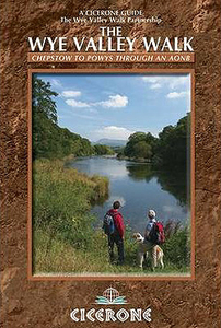
The official guide to backpacking or walking the Wye Valley Walk, 136 miles through the Welsh borders, crossing between Wales and England, from the coast at Chepstow to the slopes of Plynlimon. Easy walking on good paths, passing sites such as Tintern Abbey, Goodrich Castle, Hereford Cathedral and Hay-on-Wye. The Wye Valley Way offers a perfect mix of river and hill walking as it follows the River Wye. The walk leads through a dramatic limestone gorge, dense woodland beneath limestone crags and past peaceful river meadows in some of the most superb scenery in the heart of the Wye Valley Area of Outstanding Natural Beauty, the birthplace of tourism and the Picturesque movement. The route passes through historic Tintern, Monmouth and Ross-on-Wye and into the gentler rolling
landscape of Herefordshire with black and white villages, famed cider orchards, landscaped parks and fertile agricultural plains into the rugged uplands of Powys. This new official guide describes the whole route in detail, from Chepstow to its source in Hafren Forest, all illustrated with colour photographs and OS map extracts, and also includes a Wye Valley Walk passport, for walkers to collect stamps along the route for a permanent record of their journey.
landscape of Herefordshire with black and white villages, famed cider orchards, landscaped parks and fertile agricultural plains into the rugged uplands of Powys. This new official guide describes the whole route in detail, from Chepstow to its source in Hafren Forest, all illustrated with colour photographs and OS map extracts, and also includes a Wye Valley Walk passport, for walkers to collect stamps along the route for a permanent record of their journey.

Product Description
Reviews/Comments
Add New
Intelligent Comparison
Archived Product
Wye Valley (Walks) Stanfords
£6.99
Archived Product

South Wales Valleys Walking Stanfords
£12.95
Archived Product

Wye Valley Stanfords
£45.00
Vouchers
No voucher codes found.
Do you know a voucher code for this product or supplier? Add it to Insights for others to use.
Do you know a voucher code for this product or supplier? Add it to Insights for others to use.
 Denmark