More From Contributor
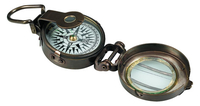
£245.00
Replica of a World War I wooden flight propeller which makes a great modern home accessory; can propped in a corner or wall mounted. Handmade in solid wood. The tapering ends elegantly swoop out at proper aerodynamic angles. Fun & fascinating home décor. If we do not have this item in stock we will order it for you from our supplier. Delivery generally takes 3 weeks within the UK. For overseas delivery queries please email sales@stanfords.co.uk ...
Archived Product
£125.00
Replica of an original propeller from the World War I era. This vintage propeller features solid wood with brass accents, red trim & a smooth, slightly distressed, honey finish. Wood propellers used to be replaced as often as tires. Old ones were usually taken home, completed with a clock, & hung over the mantel. Mechanics, pilots, flight-crew. They wore propeller tiepins & badges & transformed propellers into memorabilia. A continuation of a flight-tradition. If we do not have this item in stock we will order it for you from our supplier. Delivery generally takes 3 weeks within the UK. For overseas delivery queries please email sales@stanfords.co.uk ...
Archived Product
£210.00
Wood Replica of World War I Airplane Propeller. Natural wood finish & has been lightly distressed. The tapering ends elegantly swoop out at proper aerodynamic angles. Fun & fascinating home décor. If we do not have this item in stock we will order it for you from our supplier. Delivery generally takes 3 weeks within the UK. For overseas delivery queries please email sales@stanfords.co.uk ...
Archived Product
£110.00
Decorative replica of a WWI Biplane propeller. It is sure to become a decorative & conversational addition to your decor whether hanging over the mantel or leaning against the wall in a corner. made from solid wood & brass, the propeller has a brown finish with red tips & has been lightly distressed. Wood propellers used to be replaced as often as tires. Old ones were usually taken home, completed with a clock, & hung over the mantel. Mechanics, pilots, flight-crew. They wore propeller tiepins & badges & transformed propellers into memorabilia. A continuation of a flight-tradition. If we do not have this item in stock we will order it for you from our supplier. Delivery generally takes 3 weeks within the UK. For overseas delivery queries please email sales@stanfords.co.uk ...
Archived Product
£9.50
De Seule
- Le Bizet, map No. 36/1-2 in the topographic survey of Belgium at 1:20, 000 covering the southernmost tip of the Ypres
...
Archived Product
£9.95
Wye Canoe
- A Canoeists` guide to the River Wye provides a comprehensive overview for those who wish to explore the stunning
...
Archived Product
£45.00
Wye Valley by George Peterkern is the definitive natural history of the Wye Valley, from its appeal to the enthusiastic naturalist, to the geology, geomorphology, conservation & ecological history of this diverse area. The spectacular landscape of the Wye Valley region has attracted visitors for over 250 years. It is one of the few lowland Areas of Outstanding Natural Beauty (designated in 1971) & is dominated by the river Wye, which flows through picturesque meadows & outstanding limestone scenery alike. George Peterken, who has lived in the region for many years & helped to draft the AONB's Nature Conservation Strategy
- launched in 1999
- examines the diverse ecology, natural history, landscape & history of a district which is defined mainly by the extraordinary evolution of the river Wye as a meandering mature river entrenched into the varied geological landscape. With little previously published on the area, Peterken explores the results of conservation efforts in the region, recognising that despite the protection afforded to the

...
Archived Product
£14.99
The Wye Valley & the Forest of Dean on a detailed topographic & GPS compatible map OL14, waterproof version, from the Ordnance Survey’s 1:25, 000 Explorer series. Coverage extends from Chepstow in the south to beyond Ross-on-Wye &

Includes::
Monmouth, the Wye Valley Area of Outstanding Natural Beauty, sections of the Offa’s Dyke National Trail, Herefordshire Way, the Severn Way, Wye Valley Walk, Wysis Way, etc. MOBILE DOWNLOADS: this title & all the other OS Explorer maps include a code for downloading after purchase the digital version onto your smartphone or tablet for viewing on the OS smartphone app.OS EXPLORER SERIES: to see the list of all the titles in the OS Explorer series, both paper & waterproof versions, please click on the series link. The Explorer series, Ordnance Survey’s most detailed maps recommended for anyone enjoying outdoor activities, provides topographic coverage of Great Britain at 1:25, 000 on GPS compatible maps with hiking trails, cycling routes & extensive tourist information. Each printed map is available either on paper or as a waterproof & tear-resistant OS Active Map, as indicated in its title. Britain’s National Parks & other areas of particular tourist interest are presented on often double-sided OL (Outdoor Leisure) maps, whilst most standard format Explorers cover an area of 30 x 20km (approx. 19 x 12 miles). All three versions (paper, waterproof & digital) are the same & provide plenty of recreational & tourist information, indicating the traditional public right of way paths (except in Scotland where different laws apply), including bridleways & byways. National Trails & other long-distance paths are marked, as well as permissive footpaths or bridleways & on-road or traffic-free cycle routes with, where appropriate, their National/ Regional Cycle Network numbers. Boundaries of access land are clearly marked. A wide range of symbols provides additional tourist information, highlighting camping & caravanning sites, information offices & visitors’ centres, parking & picnicking places, country pubs, sport & recreational facilities including cycle hire locations & mountain biking trails, historic buildings & museums, etc. Exceptionally clear presentation of the landscape is provided by contours at 5m or in the uplands at 10m intervals, with additional spot heights plus colouring and/or graphics for different types of woodlands, orchards, heath, marshl&, scree or boulders, & other topographic features. For GPS users the maps have British National Grid lines at 1km intervals, with latitude & longitude given by margin ticks at 1`. Clearly laid out map legend

Includes::
French & German translations for the tourist information symbols.


...
Archived Product
£8.99
The Wye Valley & the Forest of Dean on a detailed topographic & GPS compatible map OL14, paper version, from the Ordnance Survey’s 1:25, 000 Explorer series. Coverage extends from Chepstow in the south to beyond Ross-on-Wye &

Includes::
Monmouth, the Wye Valley Area of Outstanding Natural Beauty, sections of the Offa’s Dyke National Trail, Herefordshire Way, the Severn Way, Wye Valley Walk, Wysis Way, etc. MOBILE DOWNLOADS: this title & all the other OS Explorer maps include a code for downloading after purchase the digital version onto your smartphone or tablet for viewing on the OS smartphone app.OS EXPLORER SERIES: to see the list of all the titles in the OS Explorer series, both paper & waterproof versions, please click on the series link. The Explorer series, Ordnance Survey’s most detailed maps recommended for anyone enjoying outdoor activities, provides topographic coverage of Great Britain at 1:25, 000 on GPS compatible maps with hiking trails, cycling routes & extensive tourist information. Each printed map is available either on paper or as a waterproof & tear-resistant OS Active Map, as indicated in its title. Britain’s National Parks & other areas of particular tourist interest are presented on often double-sided OL (Outdoor Leisure) maps, whilst most standard format Explorers cover an area of 30 x 20km (approx. 19 x 12 miles). All three versions (paper, waterproof & digital) are the same & provide plenty of recreational & tourist information, indicating the traditional public right of way paths (except in Scotland where different laws apply), including bridleways & byways. National Trails & other long-distance paths are marked, as well as permissive footpaths or bridleways & on-road or traffic-free cycle routes with, where appropriate, their National/ Regional Cycle Network numbers. Boundaries of access land are clearly marked. A wide range of symbols provides additional tourist information, highlighting camping & caravanning sites, information offices & visitors’ centres, parking & picnicking places, country pubs, sport & recreational facilities including cycle hire locations & mountain biking trails, historic buildings & museums, etc. Exceptionally clear presentation of the landscape is provided by contours at 5m or in the uplands at 10m intervals, with additional spot heights plus colouring and/or graphics for different types of woodlands, orchards, heath, marshl&, scree or boulders, & other topographic features. For GPS users the maps have British National Grid lines at 1km intervals, with latitude & longitude given by margin ticks at 1`. Clearly laid out map legend

Includes::
French & German translations for the tourist information symbols.


...
Archived Product
£7.99
Wye Valley & The Forest of Dean at 1:25, 000 in a series of Walker’s Maps published by the AA with the cartography from the Ordnance Survey’s Explorer series. The map is double-sided & coverage

Includes::
Ross-on-Wye, Monmouth, Whitchurch, Raglan, Usk, Chepstow, Berkeley, etc. Maps in the AA Walker’s series are identical to the OS Explorer maps & provide plenty of recreational & tourist information, indicating in England & Wales the traditional public rights of way paths, including bridleways & byways restricted or open to motorized traffic. Also shown are other routes with public access, including permissive footpaths & bridleways. For Scotl&, where different access rights apply, the maps provide an additional note explaining the regulations. Special marking indicates National Trails & Recreational Routes & for cyclists the maps show traffic-free routes & the National Cycle Network. A wide range of symbols highlights locations of special tourist interest: camping & caravanning sites, youth hostels, information offices & visitors’ centres, parking & picnicking places, historic buildings (indicating where appropriate National Trust, English Heritage, Historic Scotland or Cadw), sites for various recreational pursuits, country pubs, public toilets, etc. The maps provide detailed presentation of the topography with contours at 5 or 10m intervals, numerous spot heights & colouring and/or graphics for different types of vegetation. Additional colouring shows access l&, including areas managed by the National Trust, Forestry Commission & Woodland Trust. All the standard information expected of high quality survey mapping at this scale is included: finely graded road network, railway lines with stations, cuttings or embankments, individual isolated buildings, etc. For GPS users the British National Grid is drawn at 1km intervals.

...
Archived Product

WWII Compass

Replica World War II era military style brass compass. With a free floating dial, brass case and glass face. The compass opened the world to exploration and discovery. Invented in China thousands of years ago, it was primarily used by feng-shui priests, hired to advise on how and where to build. Today the compass still is a basic tool, a magnetized needle rotating on a vertical pin, pointing at the Earth’s magnetic North. 16th century sailors accustomed to following coastlines, could suddenly cross oceans. Sailors now devised a compass course, while still using their age-old knowledge of steering by fixed stars, ocean currents and prevailing winds to establish position.If we do not have this item in stock we will order it for you from our supplier. Delivery generally takes 3
weeks within the UK. For overseas delivery queries please email sales@stanfords.co.uk
RIP - This product is no longer available on our network. It was last seen on 25.09.2019

This page now acts as a permanent archive for this product. Add more information using the comments box below to ensure it can still be found by future generations.

Use our search facility to see if it is available from an alternative contributor.
  • External links may include paid for promotion
  • Availability: Out Of Stock
  • Supplier: Stanfords
  • SKU: 0781934564386
Availability: In Stock
£35.00

Product Description

Replica World War II era military style brass compass. With a free floating dial, brass case & glass face. The compass opened the world to exploration & discovery. Invented in China thousands of years ago, it was primarily used by feng-shui priests, hired to advise on how & where to build. Today the compass still is a basic tool, a magnetized needle rotating on a vertical pin, pointing at the Earth’s magnetic North. 16th century sailors accustomed to following coastlines, could suddenly cross oceans. Sailors now devised a compass course, while still using their age-old knowledge of steering by fixed stars, ocean currents & prevailing winds to establish position. If we do not have this item in stock we will order it for you from our supplier. Delivery generally takes 3 weeks within the UK. For overseas delivery queries please email sales@stanfords.co.uk

Reviews/Comments

Add New

Intelligent Comparison

Oooops!
We couldn't find anything!
Perhaps this product's unique.... Or perhaps we are still looking for comparisons!
Click to bump this page and we'll hurry up.

Price History

Vouchers

No voucher codes found.
Do you know a voucher code for this product or supplier? Add it to Insights for others to use.

Facebook

Jargon Buster

Brass - A copper and Zinc Alloy
UK - United Kingdom - An island nation in Europe
Glass - A solid, typically transparent. Brittle and used in windows. The first patent granted in the UK was for Glass.
magnetic - A susbstance affected at a microscopic level by an applied magnetic field.
email - An electronic communication method. Short for Electronic Mail.
delivery - The method by which something is delivered from one location to another
World - A physical grouping, commonly used to describe earth and everything associated with ti
Earth - A planet third from the sun. Similar size to Venus but rich in water and complex life.
Replica - A copy or duplicate of something.

Supplier Information

Stanfords
Stanfords was established in 1853 and opened their iconic Covent Garden flagship store in 1901. They have become the top retailer of maps, travel books and accessories in the UK and arguably offer the largest selection of maps and travel books worldwide. Famous names such as Captain Robert Falcon Scott, Ranulph Fiennes and Michael Palin have purchased from Stanfords. They now have a shop in Bristol and both stores together with other venues operate a calendar of events including talks, book signings and exhibitions. As a specialist map retailer, the map selection is comprehensive and includes road maps, street maps and walking maps from worldwide destinations, as well as a selection of world atlases and wall maps. Books include travel guides and travel literature. Stanfords also stock globes, from miniatures made of blue marble to magnificent floor-standing globes. The website features a selection of interesting articles on travel topics.
Page Updated: 2023-11-12 20:15:36

Community Generated Product Tags

Oh No! The productWIKI community hasn't generated any tags for this product yet!
Menu