
 United Kingdom
 France
 Germany
 Netherlands
 Sweden
 USA
USA
 Italy
Italy
 Spain
Spain
More From Contributor

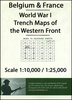


WWI Trench Map: Monchy-au-Bois - Gommecourt - Serre (57D NE - Ed. 2B)
France (57D NE - ed. 2B) in a series of British Army trench maps from the WWI, reproduced by G.H. Smith & Son at approximately 7/10th of the original scales"ed against each title. The map covers an area from Monchy-au-Bois in the north to Gommecourt and down to Serre. Trenches, corrected to 11.5.1916, are shown as they were on 1st July 1916, the first day of the Battle of the Somme.Maps in this series show both the British and the enemy trenches. Several titles also indicate supply and ammunition dumps, machine gun and trench mortar emplacements, observation posts, etc. Most titles are annotated with a specific date when they were prepared and include on the reverse a glossary of terms used on the map. Some also include additional information on the regiments and/or individual
solders connected with that particular part of the front.To see other titles in this series please click on the series link.
solders connected with that particular part of the front.To see other titles in this series please click on the series link.
 "Pin It")
Product Description
Reviews/Comments
Add New
Vouchers
No voucher codes found.
Do you know a voucher code for this product or supplier? Add it to Insights for others to use.
Do you know a voucher code for this product or supplier? Add it to Insights for others to use.
 Denmark