More From Contributor

£13.99
Area native & current Virginia resident Michaela Gaaserud provides travelers with an insider`s perspective on two of the nation`s most historically significant states. An experienced guidebook author, Gaaserud offers up original trip ideas to help visitors make the most of their time, such as Five Days for the Active Traveler & the Seven-Day Historical Road Trip & Pub Tour. With comprehensive coverage for all interests--from strolling Embassy Row & visiting the monuments in Washington DC to hiking in Shenandoah National Park, from getting some sun on Colonial Beach to seeing the Beauregard Civil War Cemetery--” Moon Virginia & Maryland” gives travelers the tools they need to create a more personal & memorable experience. ...
Archived Product
£19.99
Very attractive Executive Political Wall Map of the World from Maps International, size 136 x 84cm (53.5” x 33” approx), with countries shown in colours from the brown
- pink
- beige palette, set off by oceans in the shades of silvery grey, plus very effective background shading to highlight mountain ranges. Names of countries, cities & topographic features are given in their English versions. Within USA, Canada, Brazil & Australia the map also shows administrative boundaries with names of state or provinces. Very effective relief shading shows physical geography, with plenty of names of various topographic features such as mountain ranges, peaks, deserts, etc. Colouring of the oceans also shows different depths &

Includes::
markings for the depth of the ocean floor. Latitude & longitude lines are drawn at 15°intervals. Projection is Van der Grinten. Current edition of this map was published in late 2013 & shows both South Sudan & the revised International Date Line.


...
Archived Product
£30.00
Glow in the Dark World Wall Map, an innovative & imaginative presentation with the outlines of the continents & the islands, symbols for cities & the road network glowing in the dark, producing a very powerful image of the world as well as highlighting its more densely populated regions. When viewed in full light, the map shows countries in different shades of green against the grayish colouring of the oceans. International borders are marked (but not highlighted to glow in the dark) & in larger countries state or provincial borders are also shown. Country & city names are in their English versions. Relief shading shows main mountain ranges & both on land & the seas spot heights/depths are marked. Symbols for cities indicate the size of their population & when glowing in the dark provide an interesting picture of the population distribution across the world. The map has latitude & longitude lines at 15° intervals. Projection is Van der Grinten. ...
Archived Product
£11.99
Small, 69.5 x 53.5cm (27” x 21” approx.), political map of the world from Maps International, with countries shown in bright vivid colours against light blue oceans. Country names are in large, clearly legible print. English versions of all city names are used throughout. Within USA, Canada & Brazil internal state or provincial boundaries are indicated. Central Pacific, from Alaska/ Siberia to New Zeal&, is repeated on both sides of the map for better presentation of that region. The map has well designed relief shading to show the mountainous areas like the Rockies or the Andes, enhancing the overall presentation. The colouring of the oceans also shows different depths. Projection is Van der Grinten. Clocks show time difference from GMT (but without the map indicating the exact geographical area covered by each time zone). A decorative panel under the map displays flags of various countries.* This 1:60, 000, 000 map is also available encapsulated, laminated & with hanging strips, or framed & mounted either on pin board or on magnetic board. The same design is also available is three larger sizes
- please click on the link above to see the full list of currently available titles.
...
Archived Product
£119.99
Framed, 70 x 52cm (28” x 21” approx.), version of the small political map of the world from Maps International mounted on *pin board*. Countries are shown in bright vivid colours against light blue oceans. Country names are in large, clearly legible print. English versions of all city names are used throughout. Within USA, Canada & Brazil internal state or provincial boundaries are indicated. Central Pacific, from Alaska/ Siberia to New Zeal&, is repeated on both sides of the map for better presentation of that region. The map has well designed relief shading to show the mountainous areas like the Rockies or the Andes, enhancing the overall presentation. The colouring of the oceans also shows different depths. Projection is Van der Grinten. Clocks show time difference from GMT (but without the map indicating the exact geographical area covered by each time zone). A decorative panel under the map displays flags of various countries.* This 1:60, 000, 000 map is also available on paper, encapsulated, laminated & with hanging strips, or framed & mounted on magnetic board, & can be supplied on pin board at reduced height, without the panel of flags. The same design is also available in three larger sizes
- please click on the link above to see the full list of currently available titles.
...
Archived Product
£9.99
Political map of the world at 1:35, 000, 000 from Marco Polo, size 120 x 80cm (47” x 31.5” approx), with laminated surface. Countries are in strong colours against a light blue sea. Included are a time zones map & a panel of flags. All place names are in English. Current edition shows South Sudan. Within USA, Canada, Brazil, China, India & Australia the map shows names & boundaries of states/provinces. In Russia selected republics and/or autonomous regions are also marked. Polar regions are not included. Topography is indicated by unobtrusive relief shading, but only rivers & lakes are named. Latitude & longitude lines are drawn at 10° intervals. Projection is Van der Grinten I. The map

Includes::
an inset with regions coloured according to time zones, plus at the bottom a panel of flags with names of countries & their capitals.LAMINATED & ENCAPSULATED WALL MAPS:- LAMINATED wall maps have a thin layer of plastic usually applied to the printed side only. They can be written on with suitable marker pens without any damage to the map but, unless laminated on both sides, they are not damp-proof.- ENCAPSULATED wall maps are sealed between two sheets of plastic. They are more rigid & heavier than laminated maps of the same size. They are damp-proof & do not crinkle in humid conditions. Encapsulation gives the map a shiny surface, similar to being displayed behind glass.- PLEASE NOTE: many publishers & retailers often use these two terms interchangeably. Our map titles & descriptions follow the definitions provided above.

...
Archived Product
£3.50
Maricourt (62C NW 1- ed.2C)in a series of British Army trench maps from the WWI, reproduced by G.H. Smith & Son at Approx. 7/10th of the original scales"ed against each title. Trenches, corrected to 2.6.1916, are as on the first day of the Battle of the Somme, from Carnoy to the junction with the French Army. Maps in this series show both the British & the enemy trenches. Several titles also indicate supply & ammunition dumps, machine gun & trench mortar emplacements, observation posts, etc. Most titles are annotated with a specific date when they were prepared & include on the reverse a glossary of terms used on the map. Some also include additional information on the regiments and/or individual solders connected with that particular part of the front. To see other titles in this series please click on the series link. ...
Archived Product
£3.50
Meaulte (62D NE 2
- ed. 2B) in a series of British Army trench maps from the WWI, reproduced by G.H. Smith & Son at Approx. 7/10th
...
Archived Product
£3.50
Messines (part of sheet 28) in a series of British Army trench maps from the WWI, reproduced by G.H. Smith & Son at Approx. 7/10th of the original scales"ed against each title. The map shows an area from Wytschaete to Messines (Messen) with trenches corrected to 9.4.1916. Maps in this series show both the British & the enemy trenches. Several titles also indicate supply & ammunition dumps, machine gun & trench mortar emplacements, observation posts, etc. Most titles are annotated with a specific date when they were prepared & include on the reverse a glossary of terms used on the map. Some also include additional information on the regiments and/or individual solders connected with that particular part of the front. To see other titles in this series please click on the series link. ...
Archived Product
£15.99
Experienced travel writers Liza Prado & Gary Chandler offer up their best advice on Mexico`s Yucatan Peninsula--from exploring Mayan ruins & Caribbean beaches to visiting hotspots like Merida, Cancun, & Playa del Carmen. Prado & Chandler include unique trip ideas for a variety of travelers, such as Pyramids & Palaces, Diving & Snorkeling, & A Family Affair. With essentials on dining, transportation, & accommodations for a range of budgets, ” Moon Yucatan Peninsula” gives travelers the tools they need to create a more personal & memorable experience. ...
Archived Product

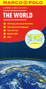
World Marco Polo Map (folded Version)

Folded version of a political map of the world at 1:30, 000, 000 from Marco Polo Travel Publishing with countries presented in pleasant pastel colours against light blue seas. Accompanying booklet or the map cover provide an index, time zone map and language groups maps, facts and figures for all the countries, etc.Country names are given as used in the country itself (Al-Maghrib, Türkiye, etc.) but with less familiar names accompanied by their English equivalents. City names are also in the local language (Athína, Dimasq, Al-Qahira), again where necessary with their English equivalents. Names of geographical features on land are in the local languages and/or English; oceans and seas are in English. On land relief shading indicates mountain ranges with main peaks. The map also
shows principal road and rail connections, and in selected larger countries (e.g. USA, Canada, Brazil or Australia) internal administrative boundaries are shown with names of states/provinces. On oceans and seas colouring shows the depth and the map shows main shipping routes. Polar Regions are not included beyond coverage of part of the coastline of Antarctica. New Zealand and the central part of the Pacific are shown on both sides of the map for clearer presentation of that region. Latitude and longitude lines are drawn at 10° intervals. The index, in a separate booklet attached to the map cover, includes geographical features such as mountains, rivers, etc. Map projection is Van der Grinten. Cartography is from the renowned German publishers MairDumont. Map legend includes
English.The booklet also includes a list of all the countries with their flag, area, population, etc, and the map cover provides maps with time zones and language groups, plus a table showing distances and flying times between selected main cities.
RIP - This product is no longer available on our network. It was last seen on 25.09.2019

This page now acts as a permanent archive for this product. Add more information using the comments box below to ensure it can still be found by future generations.

Use our search facility to see if it is available from an alternative contributor.
  • External links may include paid for promotion
  • Availability: Out Of Stock
  • Supplier: Stanfords
  • SKU: 9783829767729
Availability: In Stock
£6.99

Product Description

Folded version of a political map of the world at 1:30, 000, 000 from Marco Polo Travel Publishing with countries presented in pleasant pastel colours against light blue seas. Accompanying booklet or the map cover provide an index, time zone map & language groups maps, facts & figures for all the countries, etc. Country names are given as used in the country itself (Al-Maghrib, Türkiye, etc.) but with less familiar names accompanied by their English equivalents. City names are also in the local language (Athína, Dimasq, Al-Qahira), again where necessary with their English equivalents. Names of geographical features on land are in the local languages and/or English; oceans & seas are in English. On land relief shading indicates mountain ranges with main peaks. The map also shows principal road & rail connections, & in selected larger countries (e.g. USA, Canada, Brazil or Australia) internal administrative boundaries are shown with names of states/provinces. On oceans & seas colouring shows the depth & the map shows main shipping routes. Polar Regions are not included beyond coverage of part of the coastline of Antarctica. New Zealand & the central part of the Pacific are shown on both sides of the map for clearer presentation of that region. Latitude & longitude lines are drawn at 10° intervals. The index, in a separate booklet attached to the map cover,

Includes::
geographical features such as mountains, rivers, etc. Map projection is Van der Grinten. Cartography is from the renowned German publishers Mair Dumont. Map legend

Includes::
English. The booklet also

Includes::
a list of all the countries with their flag, area, population, etc, & the map cover provides maps with time zones & language groups, plus a table showing distances & flying times between selected main cities.

Reviews/Comments

Add New

Intelligent Comparison

Oooops!
We couldn't find anything!
Perhaps this product's unique.... Or perhaps we are still looking for comparisons!
Click to bump this page and we'll hurry up.

Price History

Vouchers

No voucher codes found.
Do you know a voucher code for this product or supplier? Add it to Insights for others to use.

Facebook

Jargon Buster

Blue - A primary colour
flag - A piece of material flown from a mast used symbolically for identification.
Brazil - A country in South America
World - A physical grouping, commonly used to describe earth and everything associated with ti
Language - the method of communication used in different areas. Humans and computers have many different languages.
Road - a manmade lane or a path that is used to speed up travel.
Language - The way humans communicate either written and spoken.

Supplier Information

Stanfords
Stanfords was established in 1853 and opened their iconic Covent Garden flagship store in 1901. They have become the top retailer of maps, travel books and accessories in the UK and arguably offer the largest selection of maps and travel books worldwide. Famous names such as Captain Robert Falcon Scott, Ranulph Fiennes and Michael Palin have purchased from Stanfords. They now have a shop in Bristol and both stores together with other venues operate a calendar of events including talks, book signings and exhibitions. As a specialist map retailer, the map selection is comprehensive and includes road maps, street maps and walking maps from worldwide destinations, as well as a selection of world atlases and wall maps. Books include travel guides and travel literature. Stanfords also stock globes, from miniatures made of blue marble to magnificent floor-standing globes. The website features a selection of interesting articles on travel topics.
Page Updated: 2023-11-12 20:15:36

Community Generated Product Tags

Oh No! The productWIKI community hasn't generated any tags for this product yet!
Menu