More From Contributor

£18.99
Political map of the world from Kümmerly+ Frey, size 140 x 99cm (55” x 39” approx) laminated, with countries in pleasant pastel colours against light blue seas, a presentation which will appeal to anyone who prefers gentler shades. Subtle relief shading with plenty of names of topographic features provides physical information. The map has English language place names throughout; countries, cities & all other features. Within USA, Canada, Brazil & Australia internal state or provincial boundaries are indicated. Principal road connections are shown, with main railway lines particularly easy to see against the background colouring. On oceans the map shows the extent of the ice shelf in the Polar Regions & main shipping lanes. Central Pacific, from Alaska/ Siberia to New Zeal&, is repeated on both sides for better presentation of that region. Projection is van der Grinten. PLEASE NOTE: Kümmerly+ Frey’s political maps of the world are published in two sizes (140x 99cm /55 x 39” approx or 190x 112cm / 75”x 44 approx), available on paper, encapsulated & on pin board or magnetic board – PLEASE CLICK ON THE SERIES LINK TO SEE ALL THE OPTIONS. ...
Archived Product
£15.99
Ancient & modern landmarks from across the world fill this original & creative design. The Elizabeth Tower (home to Big Ben) rubs shoulders with the Statue of Liberty, Sydney Opera House nestles in front of St Basil`s Cathedral, whilst The Sphinx crouches in front of Stonehenge. There are 50 famous sites to discover
- how many can you identify? Supplied with in-box leaflet listing all 50 landmarks, & additional puzzle picture for reference.
- High quality 1000 piece cardboard jigsaw puzzle.
- The finished puzzle measures 70 x 50cm when complete.
- Suitable for ages 12 years & up.
- Made from strong premium grade cardboard, with linen finish print to minimise glare on puzzle image.


...
Archived Product
£6.99
With an easy-fold, easy-to-use format, Lonely Planet World Planning Map, covering every country in the world, is your conveniently-sized passport to traveling the world with ease. Get more from your map & your travels with images & information about top attractions. Begin your journey now!- Easy-fold format- Handy slipcase- Full colour & easy-to-use- Beautiful imagery- Can`t-miss highlights- Covers Europe, North America, South America, Africa, Middle East, Asia, Oceania, Australia ...
Archived Product
£7.99
The Vintage World Map Jumbo Storage Bag is 90% made from recycled plastic bottles, is a versatile bag to neatly store away beddings, clothes, toys etc. It features an up to date colourful political map of the world, metal zip fastening & woven nylon handles. This useful & lively Storage Bag will brighten up any space. ...
Archived Product
£7.99
The World Map Jigsaw by Little Wigwam, features 100 pieces to recreate a colourful world map. The map features up-to-date cartography, longitude & latitude lines, Equator, Tropics, Arctic & Antarctic Circles. Each continent is represented in a different colour & the newest countries are included, capitals & major cities as well as holiday locations like Orlando & Bali are named. Once finished the puzzle will measure 41x 27.5cm & is recommended for age 6+. This jigsaw is a wonderful way to learn while having fun, in the classroom or at home. Designed by teachers, & made in the EU. Buy it now! ...
Archived Product
£12.99
Mc Laggan Smith World Map Mug showing an artist`s impression of the world political map, with countries depicted in four different colours. The position of the equator, the tropics of Cancer & Capricorn & the line of zero degrees longitude are marked on the mug. The mug measures 9cm diameter / 9cm depth. ...
Archived Product
£7.99
Learn the countries over your morning cuppa with the World Map mug. It`s safe to put in the dishwasher & microwave, & the perfect size for a morning or afternoon pick-me-up. Colourful & cute, it`ll be a welcome addition to any kitchen. Please note the world map is a design & not intended to be a precise geographical representation of the world. ...
Archived Product
£6.99
NYC Railway System is a paper poster railway map of New York City inspired by the shape of the heart from Milton Glaser`s ”I heart NY” logo. Famous landmarks & tourist attractions such as the Empire State Building are incorporated into the map, creating a sense of New York City as a tourist spot. City Railway System is a new approach to projecting the identity of a city onto its subway map. Whereas conventional subway maps aim at conveying information as clearly & concisely as possible, the City Railway System by Zero Per Zero instinctively incorporates symbolic elements of each city into its map while preserving clarity. As a special consideration for tourists, major landmarks & tourist attractions are indicated on the subway maps, so that tourists can easily figure out the quickest way to get to the destination at a glance. The railway map itself is also good as a souvenir. ...
Archived Product
£10.50
This is a unique notebook from Cavallini & Co. with a beautiful & robust cover featuring a vintage world map. It

Includes::


...
Archived Product
£8.50
This is a unique notebook from Cavallini & Co. with a beautiful & robust cover featuring a vintage map of the world. It


...
Archived Product

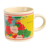
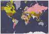
World Map Mini Children`s Back Pack

Vintage World Map Mini Children’s Backpack featuring rubber printed extract of a colourful political world map. The bright backpack offers comfort and practicality with a carrying handle and adjustable padded shoulder straps, padded back and a front zipped pocket. A colourful and useful backpag for young kids to carry going to school or on holiday.
RIP - This product is no longer available on our network. It was last seen on 25.09.2019

This page now acts as a permanent archive for this product. Add more information using the comments box below to ensure it can still be found by future generations.

Use our search facility to see if it is available from an alternative contributor.
  • External links may include paid for promotion
  • Availability: Out Of Stock
  • Supplier: Stanfords
  • SKU: 5027455390567
Availability: In Stock
£12.99

Product Description

Vintage World Map Mini Children’s Backpack featuring rubber printed extract of a colourful political world map. The bright backpack offers comfort & practicality with a carrying handle & adjustable padded shoulder straps, padded back & a front zipped pocket. A colourful & useful backpag for young kids to carry going to school or on holiday.

Reviews/Comments

Add New

Intelligent Comparison

Oooops!
We couldn't find anything!
Perhaps this product's unique.... Or perhaps we are still looking for comparisons!
Click to bump this page and we'll hurry up.

Price History

Vouchers

No voucher codes found.
Do you know a voucher code for this product or supplier? Add it to Insights for others to use.

Facebook

Jargon Buster

rubber - Synthetic rubber is any artificial elastomer, usually a polymer, and is used as a substitute for natural rubber.
rubber - Natural rubber is an elastomer derived from the latex containing sap of some plants.
World - A physical grouping, commonly used to describe earth and everything associated with ti
Comfort - something that feels nice to the user. Often relaxing.
Padded - Something with an extra cushion or boost.
Adjustable - Something that can be changed or slightly modified to fit.
Adjustable - Something that can be changed in order to fit better.
Pocket - A bag shaped insert in clothing used to carry items
Children - A young life form within the early stages of physical development,
Vintage - An older product that has become more quirky with time.
Kids - A young child.

Supplier Information

Stanfords
Stanfords was established in 1853 and opened their iconic Covent Garden flagship store in 1901. They have become the top retailer of maps, travel books and accessories in the UK and arguably offer the largest selection of maps and travel books worldwide. Famous names such as Captain Robert Falcon Scott, Ranulph Fiennes and Michael Palin have purchased from Stanfords. They now have a shop in Bristol and both stores together with other venues operate a calendar of events including talks, book signings and exhibitions. As a specialist map retailer, the map selection is comprehensive and includes road maps, street maps and walking maps from worldwide destinations, as well as a selection of world atlases and wall maps. Books include travel guides and travel literature. Stanfords also stock globes, from miniatures made of blue marble to magnificent floor-standing globes. The website features a selection of interesting articles on travel topics.
Page Updated: 2023-11-12 20:15:36

Community Generated Product Tags

Oh No! The productWIKI community hasn't generated any tags for this product yet!
Menu