More From Contributor

£17.99
The World Geo Puzzle by Geo Toys featuring a colourful map of the world & pieces shaped like countries, helping children to build their motor, cognitive, language, & problem-solving skills. This colourful jigsaw is made from 68 pieces, a lot of them with contour cut following the shape of countries, the smaller countries are grouped together so that the pieces are kept to an average size that is comfortably handled by kids. The countries feature with their names & illustrations of different types of boats sails the seas. The tiles come in a re-sealable plastic bag. Assembled the puzzle measures 66x 31.8cm/26x 12.5 inches. Made in Germany from recycled materials & developed for children aged 4+. This is a wonderful & fun way for children to learn geography & more. ...
Archived Product
£12.99
The World Geo Cards features 50 country cards which can be used to play 5 different card games to make geography fun! Each card features a country along with information such as capital, population & land area; (only the largest countries of the world have been selected). These are jumbo sized strong cards which are colourful & show on one side a country on its own, with population & total area figures, & locating the capital; on the other side the country is represented with its capital, the neighbouring states & the continent of origin, all of which are named. The pack of cards comes with instructions for playing 5 different games for 1 to 4 players. Suitable for children aged 4+. World Geo Cards are a fantastic entertaining way for children to play with geography & discover the world! ...
Archived Product
£74.00
Beautifully presented geological wall map of the world
- size 196x 100cm (77”x 39.5” approx), paper version
- designed to appeal

...
Archived Product
£94.00
Beautifully presented geological wall map of the world
- size 196x 100cm (77”x 39.5” approx), plastic coated version
- designed

...
Archived Product
£35.00
Beautifully presented geological wall map of the world
- size 100x 70cm (39.5”x 27.5” approx), paper version
- designed to

...
Archived Product
£24.99
Political map of the world from Global Mapping, large size 138 x 95cm (54” x 37.5” approx.) – encapsulated version, with bright countries pleasantly contrasted four different sizes, as indicated below. This particular version has not yet been updated to show South Sudan or the new International Date Line.GLOBAL MAPPING POLITICAL MAPS OF THE WORLD:FORMAT &

Sizes:
the maps are available on paper or encapsulated & in four

Sizes:
199 x 135cm, 138 x 95cm, 99.5 x 69.5cm & 69.5 x 61cm on paper but slightly larger when encapsulated – please see individual entries for exact measurements. PRESENTATION: country names are in English. Within Europe, city names are as used in their countries (Köln, Wien, Warszawa); elsewhere the names vary (e.g. Viangchan for Vientiane). In USA, Canada, Brazil & Australia the map shows names of states/provinces, with their borders & administrative capitals. Relief shading shows elevation on land & particularly effectively on the ocean floor. On all four sizes clocks show time difference from GMT (but without indicating the exact geographical area covered by each time zone); the International Date Line is not included on the smallest version. Small, medium & large size versions include a panel of country flags under the map.PLEASE NOTE: as the scale & the size of the map increases, each version

Includes::
more cities & more geographical information (mountain ranges, islands, etc).LAMINATED & ENCAPSULATED WALL MAPS:- LAMINATED wall maps have a thin layer of plastic usually applied to the printed side only. They can be written on with suitable marker pens without any damage to the map but, unless laminated on both sides, they are not damp-proof.- ENCAPSULATED wall maps are sealed between two sheets of plastic. They are more rigid & heavier than laminated maps of the same size. They are damp-proof & do not crinkle in humid conditions. Encapsulation gives the map a shiny surface, similar to being displayed behind glass.- PLEASE NOTE: many publishers & retailers often use these two terms interchangeably. Our map titles & descriptions follow the definitions provided above.


...
Archived Product
£11.99
Political map of the world from Global Mapping, large size 138 x 95cm (54” x 37.5” approx.) – paper version, with bright colouring of the individual countries pleasantly contrasted by the light blue oceans, relief shading for mountain ranges on land & the structure of the ocean floor, a panel of country flags, etc. The map is part of Global Mapping series of political maps presenting the world in four different sizes, as indicated below. This particular version has not yet been updated to show South Sudan or the new International Date Line.GLOBAL MAPPING POLITICAL MAPS OF THE WORLD:FORMAT &

Sizes:
the maps are available on paper or encapsulated & in four

Sizes:
199 x 135cm, 138 x 95cm, 99.5 x 69.5cm & 69.5 x 61cm on paper but slightly larger when encapsulated – please see individual entries for exact measurements. PRESENTATION: country names are in English. Within Europe, city names are as used in their countries (Köln, Wien, Warszawa); elsewhere the names vary (e.g. Viangchan for Vientiane). In USA, Canada, Brazil & Australia the map shows names of states/provinces, with their borders & administrative capitals. Relief shading shows elevation on land & particularly effectively on the ocean floor. On all four sizes clocks show time difference from GMT (but without indicating the exact geographical area covered by each time zone); the International Date Line is not included on the smallest version. Small, medium & large size versions include a panel of country flags under the map.PLEASE NOTE: as the scale & the size of the map increases, each version

Includes::
more cities & more geographical information (mountain ranges, islands, etc).


...
Archived Product
£18.99
Political map of the world from Global Mapping, medium size 99.5 x 69.5cm (39” x 27.5” approx) – encapsulated version, with bright colouring of the individual countries pleasantly contrasted by the light blue oceans, relief shading for mountain ranges on land & the structure of the ocean floor, a panel of country flags, etc. The map is part of Global Mapping series of political maps presenting the world in four different sizes, as indicated below. This particular version has not yet been updated to show South Sudan or the new International Date Line.LAMINATED & ENCAPSULATED WALL MAPS:- LAMINATED wall maps have a thin layer of plastic usually applied to the printed side only. They can be written on with suitable marker pens without any damage to the map but, unless laminated on both sides, they are not damp-proof.- ENCAPSULATED wall maps are sealed between two sheets of plastic. They are more rigid & heavier than laminated maps of the same size. They are damp-proof & do not crinkle in humid conditions. Encapsulation gives the map a shiny surface, similar to being displayed behind glass.- PLEASE NOTE: many publishers & retailers often use these two terms interchangeably. Our map titles & descriptions follow the definitions provided above.GLOBAL MAPPING POLITICAL MAPS OF THE WORLD:FORMAT &

Sizes:
the maps are available on paper or encapsulated & in four

Sizes:
199 x 135cm, 138 x 95cm, 99.5 x 69.5cm & 69.5 x 61cm on paper but slightly larger when encapsulated – please see individual entries for exact measurements. PRESENTATION: country names are in English. Within Europe, city names are as used in their countries (Köln, Wien, Warszawa); elsewhere the names vary (e.g. Viangchan for Vientiane). In USA, Canada, Brazil & Australia the map shows names of states/provinces, with their borders & administrative capitals. Relief shading shows elevation on land & particularly effectively on the ocean floor. On all four sizes clocks show time difference from GMT (but without indicating the exact geographical area covered by each time zone); the International Date Line is not included on the smallest version. Small, medium & large size versions include a panel of country flags under the map.PLEASE NOTE: as the scale & the size of the map increases, each version

Includes::
more cities & more geographical information (mountain ranges, islands, etc).


...
Archived Product
£11.99
Political map of the world from Global Mapping, small size 69.5 x 61cm (27 x 24” approx) – encapsulated version, with bright colouring of the individual countries pleasantly contrasted by the light blue oceans, relief shading for mountain ranges on land & the structure of the ocean floor, a panel of country flags, etc. The map is part of Global Mapping series of political maps presenting the world in four different sizes, as indicated below. This particular version is now available in an updated edition which

Includes::
South Sudan.LAMINATED & ENCAPSULATED WALL MAPS:- LAMINATED wall maps have a thin layer of plastic usually applied to the printed side only. They can be written on with suitable marker pens without any damage to the map but, unless laminated on both sides, they are not damp-proof.- ENCAPSULATED wall maps are sealed between two sheets of plastic. They are more rigid & heavier than laminated maps of the same size. They are damp-proof & do not crinkle in humid conditions. Encapsulation gives the map a shiny surface, similar to being displayed behind glass.- PLEASE NOTE: many publishers & retailers often use these two terms interchangeably. Our map titles & descriptions follow the definitions provided above.GLOBAL MAPPING POLITICAL MAPS OF THE WORLD:FORMAT &

Sizes:
the maps are available on paper or encapsulated & in four

Sizes:
199 x 135cm, 138 x 95cm, 99.5 x 69.5cm & 69.5 x 61cm on paper but slightly larger when encapsulated – please see individual entries for exact measurements. PRESENTATION: country names are in English. Within Europe, city names are as used in their countries (Köln, Wien, Warszawa); elsewhere the names vary (e.g. Viangchan for Vientiane). In USA, Canada, Brazil & Australia the map shows names of states/provinces, with their borders & administrative capitals. Relief shading shows elevation on land & particularly effectively on the ocean floor. On all four sizes clocks show time difference from GMT (but without indicating the exact geographical area covered by each time zone); the International Date Line is not included on the smallest version. Small, medium & large size versions include a panel of country flags under the map.PLEASE NOTE: as the scale & the size of the map increases, each version

Includes::
more cities & more geographical information (mountain ranges, islands, etc).


...
Archived Product
£7.99
Political map of the world from Global Mapping, small size 69.5 x 61cm (27 x 24” approx) – paper version, with bright colouring of the individual countries pleasantly contrasted by the light blue oceans, relief shading for mountain ranges on land & the structure of the ocean floor, a panel of country flags, etc. The map is part of Global Mapping series of political maps presenting the world in four different sizes, as indicated below. This particular version is now available in an updated edition which

Includes::
South Sudan.GLOBAL MAPPING POLITICAL MAPS OF THE WORLD:FORMAT &

Sizes:
the maps are available on paper or encapsulated & in four

Sizes:
199 x 135cm, 138 x 95cm, 99.5 x 69.5cm & 69.5 x 61cm on paper but slightly larger when encapsulated – please see individual entries for exact measurements. PRESENTATION: country names are in English. Within Europe, city names are as used in their countries (Köln, Wien, Warszawa); elsewhere the names vary (e.g. Viangchan for Vientiane). In USA, Canada, Brazil & Australia the map shows names of states/provinces, with their borders & administrative capitals. Relief shading shows elevation on land & particularly effectively on the ocean floor. On all four sizes clocks show time difference from GMT (but without indicating the exact geographical area covered by each time zone); the International Date Line is not included on the smallest version. Small, medium & large size versions include a panel of country flags under the map.PLEASE NOTE: as the scale & the size of the map increases, each version

Includes::
more cities & more geographical information (mountain ranges, islands, etc).


...
Archived Product

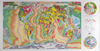
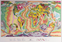
World Geological Wall Map MEDIUM, PLASTIC-COATED

Beautifully presented geological wall map of the world - size 100x70cm (39.5”x27.5” approx), plastic coated version - designed to appeal to anyone who wants to enhance their room with a bold splash of colour. The map is produced using the lithographic printing process in 10 metallic ink colours on high quality FSC approved silk-coated paper. Published in 2015 to mark the 10th anniversary of The Future Mapping Company, the map provides a laser vision of all the mega-structures and most important geological groups that have resulted from the turbulent history of the Earth`s surface over 4.56 billion years. The map can be used to trace different lithospheric plates, sub-plates and micro-plates that make up the surface of our planet, and has an informative map legend.In addition to the
geological information the map also shows the names of countries and their capitals, with plenty of names of topographic features such as mountain ranges, deserts, etc. On oceans and seas various sea floor ridges, basins, etc, are also named. All place names are in their English versions. Central Pacific with New Zealand is shown on both sides of the map for better presentation of that region and the two Polar Regions are included on insets. The map is drawn on the Winkel Tripel projection.PLEASE NOTE: this title is also available in a plastic coated version for greater durability or in a larger size, also on paper or plastic-coated. To see the list of available versions please click on the series link.
RIP - This product is no longer available on our network. It was last seen on 25.09.2019

This page now acts as a permanent archive for this product. Add more information using the comments box below to ensure it can still be found by future generations.

Use our search facility to see if it is available from an alternative contributor.
  • External links may include paid for promotion
  • Availability: Out Of Stock
  • Supplier: Stanfords
  • SKU: 9786000525484
Availability: In Stock
£45.00

Product Description

Beautifully presented geological wall map of the world
- size 100x 70cm (39.5”x 27.5” approx), plastic coated version
- designed to appeal to anyone who wants to enhance their room with a bold splash of colour. The map is produced using the lithographic printing process in 10 metallic ink colours on high quality FSC approved silk-coated paper. Published in 2015 to mark the 10th anniversary of The Future Mapping Company, the map provides a laser vision of all the mega-structures & most important geological groups that have resulted from the turbulent history of the Earth`s surface over 4.56 billion years. The map can be used to trace different lithospheric plates, sub-plates & micro-plates that make up the surface of our planet, & has an informative map legend. In addition to the geological information the map also shows the names of countries & their capitals, with plenty of names of topographic features such as mountain ranges, deserts, etc. On oceans & seas various sea floor ridges, basins, etc, are also named. All place names are in their English versions. Central Pacific with New Zealand is shown on both sides of the map for better presentation of that region & the two Polar Regions are included on insets. The map is drawn on the Winkel Tripel projection.PLEASE NOTE: this title is also available in a plastic coated version for greater durability or in a larger size, also on paper or plastic-coated. To see the list of available versions please click on the series link.

Reviews/Comments

Add New

Intelligent Comparison

Oooops!
We couldn't find anything!
Perhaps this product's unique.... Or perhaps we are still looking for comparisons!
Click to bump this page and we'll hurry up.

Price History

Vouchers

No voucher codes found.
Do you know a voucher code for this product or supplier? Add it to Insights for others to use.

Facebook

Jargon Buster

Silk - A natural fibre made by silk worms
Paper - A thin sheet mainly used for writing. Available in a variety of colours. Made mainly from wood pulp.
Ink - A liquid containing pigments and dyes
Plastic - A generic term for a synthetic product used in the manufacture of products
Wall - A physical barrier between two areas
History - Anything that happens in the past. An acedemic subject.
World - A physical grouping, commonly used to describe earth and everything associated with ti
Colour - The categorised spectrum of light visable to humans
Earth - A planet third from the sun. Similar size to Venus but rich in water and complex life.
Quality - An object that has quality is superior in function and finish than a less quality object.
Size - is the measurement of how big an object is in space.
Vision - To be able to imagine, also can mean what you can see.

Supplier Information

Stanfords
Stanfords was established in 1853 and opened their iconic Covent Garden flagship store in 1901. They have become the top retailer of maps, travel books and accessories in the UK and arguably offer the largest selection of maps and travel books worldwide. Famous names such as Captain Robert Falcon Scott, Ranulph Fiennes and Michael Palin have purchased from Stanfords. They now have a shop in Bristol and both stores together with other venues operate a calendar of events including talks, book signings and exhibitions. As a specialist map retailer, the map selection is comprehensive and includes road maps, street maps and walking maps from worldwide destinations, as well as a selection of world atlases and wall maps. Books include travel guides and travel literature. Stanfords also stock globes, from miniatures made of blue marble to magnificent floor-standing globes. The website features a selection of interesting articles on travel topics.
Page Updated: 2023-11-12 20:15:36

Community Generated Product Tags

Oh No! The productWIKI community hasn't generated any tags for this product yet!
Menu