More From Contributor

£5.99
This exciting sticker book is full of awesome colourful maps, photos & flags. With over 150 reusable stickers the book is a perfect introduction to the ever popular topic of flags. Introduces children to the ever-popular topic of flags. The book is packed with colourful illustrations, photographs & reusable stickers. It encourages young children to identify national & international flags. Each national flag is linked to its country shape or International organization. The national flag for every country, & many of their dependent territories, is included. Educational & entertaining, & full of colourful photographs. A perfect combination of learning & fun. ...
Archived Product
£14.99
Chris & Carolyn Caldicott run the famous World Food Cafe in London`s Covent Garden, where they serve vegetarian food from recipes collected on their travels. This sequel to the acclaimed World Food Cafe is an enticing & long-awaited second helping of travelogue, stunning photography & delicious vegetarian recipes from around the globe. ...
Archived Product
£25.00
Chris & Carolyn Caldicott are the godparents of global vegetarian cuisine in the UK. For twenty years their World Food Cafe in London`s Covent Garden was the hub of new flavours, colours & combinations in vegetarian cooking. World Food Cafe Vegetarian Bible collects the best recipes from two decades of globetrotting, tried & tested to be easy to make at home. Vegetarian Bible gathers together recipes previously published in World Food Cafe, World Food Cafe 2 & The Spice Routes. It forms the perfect companion to the brand new collection World Food Cafe Quick & Easy, published September 2012. More than 130 of the recipes are suitable for vegans. ...
Archived Product
£20.00
After twenty years of squeezing in trips abroad at the same time as running the World Food Cafe, Chris & Carolyn Caldicott decided to take a sabbatical so that they could go on some longer journeys in search of new recipes. This book brings together the recipes they collected on a trek across the Andes; on their way down the Ganges delta; in the mountain kingdom of Bhutan; in the remote jungle of upper Burma; & even further away. All the recipes are quick & easy to cook, ideal for life on the road or for a simple, quick & healthy meal after a busy day. With over 100 entirely vegetarian recipes from across the globe & stunning travel & food photography throughout, World Food Cafe Quick & Easy is the ultimate cookbook for preparing delicious world vegetarian food at home. ...
Archived Product
£25.00
This updated edition contains ten new categories, adding even more design ideas & football information, & revealing the answers to questions on the greatest players, finest clubs, best national teams & most dominant leagues: the Olympic Games, Japan`s J-League, FIFA World Cup & European competitions all are given fresh looks. Filled with colour on every page, World Football Infographics offers rich entertainment for football fans of all ages. Opta has earned a reputation for the breadth & accuracy of the statistics it provides on a wide range of sports, especially football. The ” Beautiful Game” has been portrayed in many ways over the years, but never in such a dynamic & interactive fashion as this. It covers every aspect of the game, from the FIFA World Cup & UEFA European Championships to the Copa America & the Africa Cup of Nations in international football to the UEFA Champions League & Europe`s most famous domestic leagues in club football. ...
Archived Product
£45.00
The map utilises, & indeed elevates, the classic Winkel Tripel projection to a bold modern aesthetic that is sure to make an impact in any interior setting. First seen in print in 1955 as The Times Atlas of the World, the projection was designed by Oswald Winkel in 1921 with the aim of minimizing the three areas of distortion faced by map makers: area, direction & distance. Thus it became the Tripel Projection (Tripel is German for triple). The result is a wonderfully spherical-looking map, which gives a graceful curve to oceans & landmasses alike. A true celebration of the beauty of mapped data. This finest top quality, 8 colour lithographic print rejoices in the freedom the craft & process allows, mixing metallic & fluorescent inks through political & physical data to dramatic effect. A stunning work of art for your home or office wall, but equally, a great reference map. Displaying countries, capital & major towns & cities, it highlights major rivers, peaks & lakes, as well as naming many physical features both on & offshore. The data is completed with inset north & south pole projections. ...
Archived Product
£13.99
Geo Bingo by Geo Toys takes on the classic game of bingo & players mark off countries instead of numbers. The goal is to get 5 countries in a row on one of the 8 geo-bingo boards. There are 50 country cards which highlight countries, capitals, landmass & population. Similar to the bingo game, a caller randomly draws countries, & players check to see if that country appears on their geo-bingo board; if it does then, they mark it with a special chip. The first person to mark off all the countries in a row is the winner.A fantastic & easy to play game for children aged 4+. ...
Archived Product
£17.99
The World Geo Puzzle by Geo Toys featuring a colourful map of the world & pieces shaped like countries, helping children to build their motor, cognitive, language, & problem-solving skills. This colourful jigsaw is made from 68 pieces, a lot of them with contour cut following the shape of countries, the smaller countries are grouped together so that the pieces are kept to an average size that is comfortably handled by kids. The countries feature with their names & illustrations of different types of boats sails the seas. The tiles come in a re-sealable plastic bag. Assembled the puzzle measures 66x 31.8cm/26x 12.5 inches. Made in Germany from recycled materials & developed for children aged 4+. This is a wonderful & fun way for children to learn geography & more. ...
Archived Product
£12.99
The World Geo Cards features 50 country cards which can be used to play 5 different card games to make geography fun! Each card features a country along with information such as capital, population & land area; (only the largest countries of the world have been selected). These are jumbo sized strong cards which are colourful & show on one side a country on its own, with population & total area figures, & locating the capital; on the other side the country is represented with its capital, the neighbouring states & the continent of origin, all of which are named. The pack of cards comes with instructions for playing 5 different games for 1 to 4 players. Suitable for children aged 4+. World Geo Cards are a fantastic entertaining way for children to play with geography & discover the world! ...
Archived Product
£74.00
Beautifully presented geological wall map of the world
- size 196x 100cm (77”x 39.5” approx), paper version
- designed to appeal

...
Archived Product

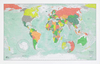
World Future Mapping Winkel Tripel Wall Map PAPER

The map utilises, and indeed elevates, the classic Winkel Tripel projection to a bold modern aesthetic that is sure to make an impact in any interior setting. First seen in print in 1955 as The Times Atlas of the World, the projection was designed by Oswald Winkel in 1921 with the aim of minimizing the three areas of distortion faced by map makers: area, direction and distance. Thus it became the Tripel Projection (Tripel is German for triple). The result is a wonderfully spherical-looking map, which gives a graceful curve to oceans and landmasses alike. A true celebration of the beauty of mapped data. This top quality, 8 colour lithographic print rejoices in the freedom the craft and process allows, mixing metallic and fluorescent inks through political and physical data to
dramatic effect. A stunning work of art for your home or office wall, but equally, a great reference map. Displaying countries, capital and major towns and cities, it highlights major rivers, peaks and lakes, as well as naming many physical features both on and offshore. The data is completed with inset north and south pole projections.
RIP - This product is no longer available on our network. It was last seen on 25.09.2019

This page now acts as a permanent archive for this product. Add more information using the comments box below to ensure it can still be found by future generations.

Use our search facility to see if it is available from an alternative contributor.
  • Availability: Out Of Stock
  • Supplier: Stanfords
  • SKU: 9786000604103
Availability: In Stock
£35.00

Product Description

The map utilises, & indeed elevates, the classic Winkel Tripel projection to a bold modern aesthetic that is sure to make an impact in any interior setting. First seen in print in 1955 as The Times Atlas of the World, the projection was designed by Oswald Winkel in 1921 with the aim of minimizing the three areas of distortion faced by map makers: area, direction & distance. Thus it became the Tripel Projection (Tripel is German for triple). The result is a wonderfully spherical-looking map, which gives a graceful curve to oceans & landmasses alike. A true celebration of the beauty of mapped data. This finest top quality, 8 colour lithographic print rejoices in the freedom the craft & process allows, mixing metallic & fluorescent inks through political & physical data to dramatic effect. A stunning work of art for your home or office wall, but equally, a great reference map. Displaying countries, capital & major towns & cities, it highlights major rivers, peaks & lakes, as well as naming many physical features both on & offshore. The data is completed with inset north & south pole projections.

Reviews/Comments

Add New

Intelligent Comparison

Oooops!
We couldn't find anything!
Perhaps this product's unique.... Or perhaps we are still looking for comparisons!
Click to bump this page and we'll hurry up.

Price History

Vouchers

No voucher codes found.
Do you know a voucher code for this product or supplier? Add it to Insights for others to use.

Facebook

Jargon Buster

Paper - A thin sheet mainly used for writing. Available in a variety of colours. Made mainly from wood pulp.
Physical - Used to describe strength or visual properties of an item
Wall - A physical barrier between two areas
World - A physical grouping, commonly used to describe earth and everything associated with ti
Office - A room where people work
Colour - The categorised spectrum of light visable to humans
Quality - An object that has quality is superior in function and finish than a less quality object.
Home - A place of permanent residence for families.
Classic - Something that is still like it was originally a high quality standard.
Interior - The inside of something, usually what is not visible.
Reference - To prove evidence with a back up source.
Print - A mechanical process of putting text onto paper. It can also relate to a pattern on an item.

Supplier Information

Stanfords
Stanfords was established in 1853 and opened their iconic Covent Garden flagship store in 1901. They have become the top retailer of maps, travel books and accessories in the UK and arguably offer the largest selection of maps and travel books worldwide. Famous names such as Captain Robert Falcon Scott, Ranulph Fiennes and Michael Palin have purchased from Stanfords. They now have a shop in Bristol and both stores together with other venues operate a calendar of events including talks, book signings and exhibitions. As a specialist map retailer, the map selection is comprehensive and includes road maps, street maps and walking maps from worldwide destinations, as well as a selection of world atlases and wall maps. Books include travel guides and travel literature. Stanfords also stock globes, from miniatures made of blue marble to magnificent floor-standing globes. The website features a selection of interesting articles on travel topics.
Page Updated: 2023-11-12 20:15:36

Community Generated Product Tags

Oh No! The productWIKI community hasn't generated any tags for this product yet!
Menu