
 United Kingdom
 France
 Germany
 Netherlands
 Sweden
 USA
USA
 Italy
Italy
 Spain
Spain
More From Contributor


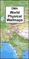
World: DMA Physical Wall Maps
Physical maps of the world regularly featured in numerous style magazines, such as Homes and Gardens and Elle Decoration. Country names and international boundaries are clearly displayed to provide political information. The maps, usually referred to by their publishers` old name of Defense Mapping Agency, are available in three sizes, presented on paper or encapsulated.Fewer cities and names of geographical features are shown than on other maps of similar size to make political boundaries stand out better and to give the maps their characteristic uncluttered look much favoured by interior designers for homes, offices and, in particular, travel agencies. Country names are in English and cities mostly in local languages (Warszawa, Wien, El Qâhira) with, where necessary, English
equivalents.Numerous shipping lanes show distances between ports in nautical miles. Clocks indicate time difference from GMT (but without the maps showing the exact geographical area covered by each time zone). The largest size is overlaid with a grid of latitude and longitude at intervals of 1’ to help identify accurate position of various locations. Projection is Mercator.* Similar design is also used for a spectacular, huge (396 x 264cm / 13’ft x 8ft 8” approx.) *wallpaper* set supplied with wallpaper paste - to view it, please enter ‘*110377*’ in the search box above.
equivalents.Numerous shipping lanes show distances between ports in nautical miles. Clocks indicate time difference from GMT (but without the maps showing the exact geographical area covered by each time zone). The largest size is overlaid with a grid of latitude and longitude at intervals of 1’ to help identify accurate position of various locations. Projection is Mercator.* Similar design is also used for a spectacular, huge (396 x 264cm / 13’ft x 8ft 8” approx.) *wallpaper* set supplied with wallpaper paste - to view it, please enter ‘*110377*’ in the search box above.

Product Description
Reviews/Comments
Add New
Vouchers
No voucher codes found.
Do you know a voucher code for this product or supplier? Add it to Insights for others to use.
Do you know a voucher code for this product or supplier? Add it to Insights for others to use.
 Denmark