More From Contributor
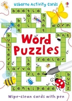
£65.00
Worcestershire, an original antique map by G. Cole / J. Roper published in London, 1810-1843. Copperplate, coloured. Map size 23 x 17 cm, overall mounted size 38.5 x 32.5 cm. This detailed map of Worcestershire is from Dugdale's England & Wales Delineated. The map was drawn by G. Cole & engraved by John Roper for publication first in The Beauties Of England & Wales, issued in parts, from c.1804. Such was the success of the publication that the maps were re-used in other publications, as here. The maps show accurate geographical detail, including the turnpike, mail coach & principal roads, sites of Roman & other historical remains, as well as the seats of the nobility & the gentry, & market towns with their distances from London. The maps also show the division of the counties into hundreds or wapontakes. They are representative of the functional nineteenth-century approach to cartography, yet are not unattractive. Antique maps from various original publishers are presented on the Stanford ...
Archived Product
£90.00
Worcestershire, an original antique map by G. Cole / J. Roper, published in London, c. 1804 -1810. A copperplate engraving, original colour. Map size 23 x 17.5 cm with a mount size of 39.5 x 33.5 cm.A detailed nineteenth-century map of Worcestershire that was published in the atlas, The British Atlas; Comprising A Complete Set Of County Maps, Of England & Wales; & Plans Of Cities & Principal Towns in 1810. The map was drawn by G. Cole & engraved by John Roper for publication in The Beauties Of England & Wales, that was published in parts, from c.1804. Such was the success of the publication that the maps were re-used in other publications, as here. The maps show accurate geographical detail, including the turnpike, mail coach & principal roads, sites of Roman & other historical remains, as well as the seats of the nobility & the gentry, & market towns with their distances from London. The maps also show the division of the counties into hundreds or wapontakes. They are representative of the functional nineteenth-century approach to cartography, yet are not unattractive. Antique maps from various original publishers are presented on the Stanford ...
Archived Product
£35.00
Worcestershire Pevsner Architectural Guide, in a series of publications begun with the express aim of providing up-to-date guides to the most significant buildings in every part of the country, suitable for both general reader & specialist. Each volume provides an introductory overview of the architecture of the area, followed by a descriptive gazetteer arranged alphabetically by place. Whilst cathedrals & their furnishings, great country houses & their parks form the grand set pieces, the books demonstrate the enjoyable diversity of architecture in the British Isles in accounts of rural churches & farmsteads, Victorian public buildings & industrial monuments. A continuing programme of publication keeps the series up-to-date with new information on older buildings & recent architecture while maintaining the tradition of Pevsner`s own succinct accounts. Each book has over 100 photographs, mostly specially commissioned, numerous maps & plans, a glossary & indexes. ...
Archived Product
£95.00
Worcester, an original antique map by G. Cole / J. Roper, published in London, c. 1804 -1810. A copperplate engraving, uncoloured. Map size 17.5 x 23 cm with a mount size of 35 x 40 cm.A detailed nineteenth-century map of Worcester that was published in the atlas, The British Atlas; Comprising A Complete Set Of County Maps, Of England & Wales; & Plans Of Cities & Principal Towns in 1810. The map was drawn by G. Cole & engraved by John Roper for publication in The Beauties Of England & Wales, that was published in parts, from c.1804. Such was the success of the publication that the maps were re-used in other publications, as here. Antique maps from various original publishers are presented on the Stanford ...
Archived Product
£24.99
The area of Greater London intricately & imaginatively visualized from words connected with its various districts & locations. Made up from names of famous Londoners & visitors to the capital, historical events, iconic buildings, dishes & much, much more, the map may not be ideal for navigating London ...
Archived Product
£6.99
Your words are amazing! This book is about your heart. The little bit inside of you that makes you, you! A very timely book about the power of words
- & how we use them. Told through the eyes of Pip & Cat, this book beautifully demonstrates the importance of what we say
- both positive & negative. Thoughtful, warm-hearted & completely non-preachy, this is a book that has already resonated with large numbers of children, whose teachers report a sea of change in the culture of their classroom after reading it. A universal message, for a world that always needs a little more kindness.

...
Archived Product
£6.99
Your words are amazing! This book is about your heart. The little bit inside of you that makes you, you! A new mini hardback gift edition of this very timely book about the power of words
- & how we use them. Told through the eyes of Pip & Cat, this book beautifully demonstrates the importance of what we say
- both positive & negative. Thoughtful, warm-hearted & completely non-preachy, this is a book that has already resonated with large numbers of children, whose teachers report a sea of change in the culture of their classroom after reading it. ` It`s a great way to encourage discussion & to share the power of words` Parents in Touch `A beautiful book that tells a strong story that spans all generations`
- Donna J ` Truly beautiful & effective`
- Jo E ` Possibly the most beautiful present I have ever received`
- Lisa W A universal message, for a world that always needs a little more kindness by an exciting new talent in picture books, Kate Jane Neal.


...
Archived Product
£9.99
This is a gathering of Patrick Leigh Fermor s most evocative writings, culled from his books, journalism & letters, many of which are published here in paperback book form for the first time. Contained within is a collection of extraordinary anecdotes that are full of atmosphere & incident, revealing Leigh Fermor to be a congenial, cultured traveller of the highest order. The pieces are arranged in five sections. These include accounts of his journeys in India, Italy, Germany, Romania & the Caribbean, details of the curious incidents & customs that he encounters in his adopted country of Greece, descriptions of his friends, heroes & various eccentrics, a selection of reviews & critical essays & a number of more frivolous, lighthearted writings. Whether tramping across Europe, searching for Lord Byron s slippers in Missolonghi or watching dolphins diving in the Mediterranean, Leigh Fermor remains infectiously enthusiastic & insatiably curious. His passion for words & language make him a superb prose writer. A master stylist, he conveys delight readily & insight easily, making him the leading exponent of the travel writing genre & a pleasure to read. ...
Archived Product
£8.99
Freedom, speed, possibilty, meditative space & a means to get around---the pleasures that come from riding a bike are deep, & even the casual cyclist can feel the connection that has propelled us forward as inventors, travellers & thinkers. Gathered here are the entertaining, inspiring, & philosophical thoughts about cycling from writers (and riders) including Diane Ackerman, Albert Einstein, Susan B. Anthony, Mark Twain, Vladimir Nabokov, Carl Sagan, Iris Murdoch, & many more, thoughtfully & playfully paired with black & white photos & illustrations depicting a history of people & bikes. ...
Archived Product
£2.95
Wordsley in 1901 in a fascinating series of reproductions of old Ordnance Survey plans in the Alan Godfrey Editions, ideal for anyone interested in the history of their neighbourhood or family. Selected towns in Great Britain & Ireland are covered by maps showing the extent of urban development in the last decades of the 19th & early 20th century. In this title: the map covers much of Wordsley, at the edge of the Black Country. Coverage extends from Holy Trinity church westward to Lawns Wood & the Kidderminster-Wolverhampton road. The map is a semi-rural one & the main features are at Wordsley, where they include Holy Trinity church, Wordsley House, Wordsley Flint Glass Works, Woodfield House, disused glass works, rectory, The Green, Bellevue area, Old Tack Farm. A section of the Stourbridge Canal is shown, including The Junction, & disused Dial Iron Works & Audnam Foundry. About the Alan Godfrey Editions of the 25 ...
Archived Product

Word Puzzles

This is an addition to already successful series of puzzle activity cards. The puzzles help improve word skills, such as vocabulary skills, spelling skills, and recognizing synonyms, antonyms and syllables. It offers an enjoyable way to reinforce vital learning skills. The cards are wipe clean and come with a special pen, making the pack entirely self contained, easily portable and ideal for journeys and holidays.
RIP - This product is no longer available on our network. It was last seen on 25.09.2019

This page now acts as a permanent archive for this product. Add more information using the comments box below to ensure it can still be found by future generations.

Use our search facility to see if it is available from an alternative contributor.
  • External links may include paid for promotion
  • Availability: Out Of Stock
  • Supplier: Stanfords
  • SKU: 9781409536796
Availability: In Stock
£5.99

Product Description

This is an addition to already successful series of puzzle activity cards. The puzzles help improve word skills, such as vocabulary skills, spelling skills, & recognizing synonyms, antonyms & syllables. It offers an enjoyable way to reinforce vital learning skills. The cards are wipe clean & come with a special pen, making the pack entirely self contained, easily portable & ideal for journeys & holidays.

Reviews/Comments

Add New

Intelligent Comparison

Oooops!
We couldn't find anything!
Perhaps this product's unique.... Or perhaps we are still looking for comparisons!
Click to bump this page and we'll hurry up.

Price History

Vouchers

No voucher codes found.
Do you know a voucher code for this product or supplier? Add it to Insights for others to use.

Facebook

Jargon Buster

Learning - Educating and growing in intelligence.
Puzzle - A problem usually in need of thought for a solution.
Wipe - To rub a cloth (or similar) along something generally to clean or dry
Ideal - Something that satisfies a perfect criteria.
Vocabulary - The collaboration of words used in a language.

Supplier Information

Stanfords
Stanfords was established in 1853 and opened their iconic Covent Garden flagship store in 1901. They have become the top retailer of maps, travel books and accessories in the UK and arguably offer the largest selection of maps and travel books worldwide. Famous names such as Captain Robert Falcon Scott, Ranulph Fiennes and Michael Palin have purchased from Stanfords. They now have a shop in Bristol and both stores together with other venues operate a calendar of events including talks, book signings and exhibitions. As a specialist map retailer, the map selection is comprehensive and includes road maps, street maps and walking maps from worldwide destinations, as well as a selection of world atlases and wall maps. Books include travel guides and travel literature. Stanfords also stock globes, from miniatures made of blue marble to magnificent floor-standing globes. The website features a selection of interesting articles on travel topics.
Page Updated: 2023-11-12 20:15:36

Community Generated Product Tags

Oh No! The productWIKI community hasn't generated any tags for this product yet!
Menu