More From Contributor
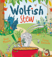
£8.95
Map No. 018, Wolfgangsee
- Fuschlsee
- Mondsee, with a panorama map on the reverse, in a series of hiking maps from Kompass

...
Archived Product
£11.99
Wolfgangsee
- Fuschlsee
- Mondsee, the lakes of the Salzkammergut area east of Salzburg, on a detailed, GPS compatible map

...
Archived Product
£11.99
The Bunny family has adopted a wolf son, & daughter. Dot is the only one who realises Wolfie is going to eat them all up! Dot tries to get through to her parents, but they are too smitten to listen. A new brother takes getting used to & when (in a twist of fate) it`s Wolfie who`s threatened, will his big sister Dot save the day? ...
Archived Product
£6.99
The Bunny family has adopted a wolf son, & daughter Dot is the only one who realises Wolfie is going to eat them all up! Dot tries to get through to her parents, but they are too smitten to listen. A new brother takes getting used to & when (in a twist of fate) it`s Wolfie who`s threatened, will his big sister Dot save the day? ...
Archived Product
£6.99
Wolfie was no ordinary wolf. He was a wolf with a difference. He had a special, super secret that nobody knew... Wolfie is supposed to be a big bad wolf. Unfortunately though, he`s not very good at it
- & worse yet, he has a terrible secret. Instead of gobbling up little pigs, Wolfie would much rather be wolfing down... cakes! Yes, it`s true
- this big, burly wolf is a star baker in the making. But can he keep his secret from those pesky little pigs? This stunning debut from author/illustrator Nicola Senior is a playful take on an old favourite tale, & one sure to make you laugh as you root for a wonderful new hero.

...
Archived Product
£11.50
Wolfratshausen in a series of GPS compatible recreational editions of the Bavarian topographic survey at 1:25, 000, with waymarked hiking trails & cycling routes, campsites & youth hostels, etc. Coverage

Includes::
Geretsried, Icking, Egling, Dietramszell, Königsdorf, Sauerlach. Contours used in this map vary between 5 to 20m according to the terrain, with 20m interval predominantly used for hilly areas. Varied colouring show different types of landscape: woods, vineyards, fields etc. Maps in this series feature extensive overprint highlighting local & long-distance footpaths & cycle routes, including King Ludwig Way or different variants of the Way of St James, indicating their waymarking. Symbols highlight different types of accommodation (campsites, youth hostels, refuges, etc), sport & recreational facilities, various places of interest, etc. The maps have a 1-km UTM grid. Map legend & all the text are in German only. To see other titles in this series please click on the series link.

...
Archived Product
£4.95
ADAC, Germany's equivalent of the British Automobile Association publishes an extensive series of street plans which provide detailed high-quality mapping of all the major towns & cities, including their outer suburbs. The plans name all the individual streets & indicate all the main landmarks & public buildings. All public transport facilities are shown: buses, trams, underground & overland rail lines. One way streets & car parks are indicated. Plans of larger cities include an enlargement for the city centre. The plans also show the administrative & postal divisions & have an extensive street index which, where appropriate, shows individual postal codes for each street. On the reverse, each plan has a road map at 1:100, 000, covering a very wide area around the city. Map legend

Includes::
English.

...
Archived Product
£7.99
Falk, one of Germany`s leading publishers of street plans, produce their town plans in two different formats. Falk Extra plans are folded in a standard way, where the whole map can be opened to view the entire area it covers. For larger cities, the same mapping is also published with a special folding system designed to show only a small section of the map at one time. The whole map can be opened but it will be cut in several places. Many find these street plans very user-friendly & easier to handle than conventional maps. The plans, which cover towns with their outer suburbs, indicate main landmarks & public buildings & show all the public transport facilities, one way streets & car parks. Plans of lager cities include a separate map of the town centre at a more detailed scale & a diagram of the underground & the suburban rail network. The plans also show the postal divisions & have an extensive street index which, where appropriate, shows individual postal codes for each street. Map legend

Includes::
English. Falk Extra plans also include on the reverse a road map of the surrounding area.

...
Archived Product
£12.99
Map No. 1149, Wolhusen, in the topographic survey of Switzerland at 1:25, 000 from Bundesamt für Landestopographie (swisstopo), covering the whole country on 247 small format sheets, with special larger maps published for popular regions including some titles now available in hiking versions. Highly regarded for their superb use of graphic relief & hill shading, the maps give an almost 3-D picture of Switzerland`s mountainous terrain. Contours are at 10 m intervals, with 20m intervals in the mountainous areas. All the maps have a 1-km grid for Swiss national coordinates (datum CH 1903). * Small format sheets (Nos. 1011
- 1374)* Map legend in the language of the area covered by the map. Additional margin ticks show latitude & longitude in steps of 2`. The area covered by each map is 17 x 12 km (11 x 7 miles approx). * Special larger sheets (Nos. from 2501 onwards) – STANDARD editions:* No map legend is included but a separate leaflet can be provided instead. The area covered by each map is 25 x 17 km (15 x 11 miles approx).* Special larger sheets (Nos. from 2501 onwards) – HIKING editions:* An overprint highlights hiking, mountain & alpine paths, including regional & national long-distance trails. The maps also show bus routes with bus stops, plus inns in remote locations. The area covered by each map is 25 x 17 km (15 x 11 miles approx).
...
Archived Product
£12.99
Wolin Island
- Wolinski National Park in a series covering Poland’s best hiking areas on waterproof & tear-resistant, laminated
...
Archived Product

Wolfish Stew

There once was a rabbit, his name was Grey he went to the woods to pick berries one day.. .Grey, the hero of our story, has heard stories about Blue; a stinky mean old wolf who wants to eat little Grey in his Wolfish Stew. So, to keep from being caught Grey sticks to the path, he stays on the trail, and he always ALWAYS looks out for the big bushy tail...But what`s that?! Wolfish knees...a Wolfish snout...? Oh, please, Grey! Please watch out! A brilliantly funny and energetic story with a deliciously unexpected outcome. For fans of The Gruffalo.
RIP - This product is no longer available on our network. It was last seen on 25.09.2019

This page now acts as a permanent archive for this product. Add more information using the comments box below to ensure it can still be found by future generations.

Use our search facility to see if it is available from an alternative contributor.
  • External links may include paid for promotion
  • Availability: Out Of Stock
  • Supplier: Stanfords
  • SKU: 9781408844953
Availability: In Stock
£6.99

Product Description

There once was a rabbit, his name was Grey he went to the woods to pick berries one day.. . Grey, the hero of our story, has heard stories about Blue; a stinky mean old wolf who wants to eat little Grey in his Wolfish Stew. So, to keep from being caught Grey sticks to the path, he stays on the trail, & he always ALWAYS looks out for the big bushy tail... But what`s that?! Wolfish knees...a Wolfish snout...? Oh, please, Grey! Please watch out! A brilliantly funny & energetic story with a deliciously unexpected outcome. For fans of The Gruffalo.

Reviews/Comments

Add New

Intelligent Comparison

Oooops!
We couldn't find anything!
Perhaps this product's unique.... Or perhaps we are still looking for comparisons!
Click to bump this page and we'll hurry up.

Price History

Vouchers

No voucher codes found.
Do you know a voucher code for this product or supplier? Add it to Insights for others to use.

Facebook

Jargon Buster

Grey - A colour often associated with old age (going grey)
Blue - A primary colour
Rabbit - A small animal found in several parts of the world both wild and domesticated
Watch - A small clock designed to be worn on a person
Day - The time it takes a planet or other space objects to complete one rotation.
Energetic - A fast pace.

Supplier Information

Stanfords
Stanfords was established in 1853 and opened their iconic Covent Garden flagship store in 1901. They have become the top retailer of maps, travel books and accessories in the UK and arguably offer the largest selection of maps and travel books worldwide. Famous names such as Captain Robert Falcon Scott, Ranulph Fiennes and Michael Palin have purchased from Stanfords. They now have a shop in Bristol and both stores together with other venues operate a calendar of events including talks, book signings and exhibitions. As a specialist map retailer, the map selection is comprehensive and includes road maps, street maps and walking maps from worldwide destinations, as well as a selection of world atlases and wall maps. Books include travel guides and travel literature. Stanfords also stock globes, from miniatures made of blue marble to magnificent floor-standing globes. The website features a selection of interesting articles on travel topics.
Page Updated: 2023-11-12 20:15:36

Community Generated Product Tags

Oh No! The productWIKI community hasn't generated any tags for this product yet!
Menu