
 United Kingdom
 France
 Germany
 Netherlands
 Sweden
 USA
USA
 Italy
Italy
 Spain
Spain
More From Contributor


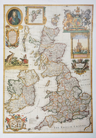
Willdey`s British Isles 1715
Reproduced from George Willdey`s ”The British Isles”, London, circa 1715, this clear and detailed map reproduction is flanked by panels of ornate motifs. Coloured lines mark county boundaries and latitude and longitude lines are drawn at 1 degree intervals. Scotland, England, Wales and Ireland are included, and the entire work is embellished with strapwork cartouches.

Product Description
Reviews/Comments
Add New
Vouchers
No voucher codes found.
Do you know a voucher code for this product or supplier? Add it to Insights for others to use.
Do you know a voucher code for this product or supplier? Add it to Insights for others to use.
 Denmark