More From Contributor

£2.95
Westmorland 1610 Replica Map by the Old Map Company is a reproduction of the map created for the famous atlas of the period by the master map maker John Speede Esq. The Old Map Company has recreated the antique maps of British counties, European cities & World countries originally crafted by master map maker John Speede Esq. whose work had accuracy & quality not surpassed for centuries. Each map is treated & presented on specially crafted paper then h&-treated giving it texture & an aged appearance before being beautifully engraved & detailed. ...
Archived Product
£75.00
Westmorel&, an original antique map by J. Seller / F. Grose, published in London, 1694 -c.1785. A copperplate engraving, coloured. Map size 14 x 12 cm with a mount size of 37 x 30 cm. An attractive miniature map of Westmoreland with an accompanying description of the county. Francis Grose (c.1731-1791) was an antiquary & draughtsman responsible for the Antiquities Of England & Wales. The work was published in six volumes between 1773 & 1787, & the 52 maps contained therein were reprints (with some alterations) of the maps from John Seller's Anglia Contracta, first published in 1695. Antique maps from various original publishers are presented on the Stanford ...
Archived Product
£280.00
Westmorl&, an original antique map by R. Morden published in London, 1695-1722-. Copperplate, coloured. Map size 43 x 36 cm, overall mounted size 59 x 52 cm. An attractive & popular map of Westmorl&. Considering the popularity & success of Camden's Britannia, first issued with maps in 1607, it is surprising that it was not until the end of the seventeenth century that a new edition was prepared. Robert Morden (d.1703) was commissioned to engrave a set of county maps for Edmund Gibson's new edition. Morden's first series of maps were rejected as being too small, & these were later published in Morden's New Description & State of Engl&, first issued in 1701, & subsequently re-issued in Cox's Magna Britannia, in the 1720s. Morden finally produced a new set of maps on a larger scale which were used in Gibson's editions published in 1695, 1722 as here, circa 1730, 1753 & 1772. The maps were based on the most up-to-date surveys where available, although some drew on Saxton & Speed, & were engraved by Sutton Nicholls & John Sturt. The maps are plain & simple, invariably with decorative title surround, & charmingly engraved. Their detail, convenient size, visual attraction & antiquity make them among the most popular of all early county maps. Antique maps from various original publishers are presented on the Stanford ...
Archived Product
£140.00
A Modern Map Of Westmoreland Drawn From The Latest Surveys, an original antique map by J. Ellis, published in London 1765-1768. A copperplate engraving, original o/l colour. Map size 25 x 19.5 cm, overall mounted size 40.5 x 34.5 cm. An attractive map of the county complete with the major roads. Borough towns are shown with stars identifying the number of members returned to parliament & Places where Fairs are kept have a Line under the Name thus. Ellis (d.1796) was a prolific English engraver of the late eighteenth century who joined with William Palmer to produce a set of English county maps, published in Ellis' New English Atlas, in 1765. The maps were later used in Ellis' English Atlas; or a Complete Cartography of England & Wales published in 1766, & reprinted in 1768
- this map comes from the 1768 edition. Ellis engraved some of the maps himself, while others were engraved by Louis de la Rochette, Palmer & W. Fowler. The maps themselves were closely based on Kitchin's maps from Dodsley's England Illustrated. Ellis' atlases were very popular, being often reprinted, as the maps are clearly & distinctively engraved with decorative title cartouches. Antique maps from various original publishers are presented on the Stanford
...
Archived Product
£65.00
Westmorel&, an original antique map by G. Cole / J. Roper published in London, 1810-1843. Copperplate, coloured. Map size 17x 23 cm, overall mounted size 38.5 x 32.5 cm. This detailed map of Westmorland is from Dugdale's England & Wales Delineated. The map was drawn by G. Cole & engraved by John Roper for publication first in The Beauties Of England & Wales, issued in parts, from c.1804. Such was the success of the publication that the maps were re-used in other publications, as here. The maps show accurate geographical detail, including the turnpike, mail coach & principal roads, sites of Roman & other historical remains, as well as the seats of the nobility & the gentry, & market towns with their distances from London. The maps also show the division of the counties into hundreds or wapontakes. They are representative of the functional nineteenth-century approach to cartography, yet are not unattractive. Antique maps from various original publishers are presented on the Stanford ...
Archived Product
£5.99
Westmorland Way (95 miles) is the Hillside mini guide to walking the long-distance route from Appleby in the Pennines, through the Lake District to Morecambe Bay. Hillside Great Britain Mini Walking Guides series is a collection of mini guides by Paul Hannon to the walking country in Great Britain. Featured walks are presented with route detail text, relevant summit/ascent data, start position, distance, national grid references, Ordnance Survey map details, access information & simple black & white overview route maps. Guides feature a table of summits & walk log. ...
Archived Product
£3.50
Weston East in 1902 in a fascinating series of reproductions of old Ordnance Survey plans in the Alan Godfrey Editions, ideal for anyone interested in the history of their neighbourhood or family. The map covers the eastern part of Weston-super-Mare, extending east & north to Baytree Farm & Home Farm in Milton. Features include the GWR station, goods station, engine shed, St Saviour`s church, Victoria Hall, cemetery, Manor Farm, Landemann Circus, Ashcombe, The Lodge, tramway & depot. The Weston Clevedon & Portishead Light Railway is shown between Weston & Milton Road. On the reverse is a list of private residents, entries H-Y. The map links up with Sheet 9.15 for Weston-super-Mare to the west. About the Alan Godfrey Editions of the 25” OS Series Selected towns in Great Britain & Ireland are covered by maps showing the extent of urban development in the last decades of the 19th & early 20th century. The plans have been taken from the Ordnance Survey mapping & reprinted at about 15 inches to one mile (1:4, 340). On the reverse most maps have historical notes & many also include extracts from contemporary directories. Most maps cover about one mile (1.6kms) north/south, one & a half miles (2.4kms) across; adjoining sheets can be combined to provide wider coverage.FOR MORE INFORMATION & A COMPLETE LIST OF ALL AVAILABLE TITLES PLEASE CLICK ON THE SERIES LINK. ...
Archived Product
£5.59
Map No. 182, Weston-super-Mare, in the Ordnance Survey Landranger series at 1:50, 000, including Bridgewater, Nailsea, Street, Wells, Gladstonbury, Highbridge, Burnham-on-Sea, Yatton, Backwell, Claveham, Dundry, Chew Magna, Congresbury, Blagdon, Banwell, Bleadon, Brean, Berrow, East Brent, Axbridge, Winscombe, Cheddar, Chewton Mendip, Westbury-sub-Mendip, Wedmore, Wookey, Coxley, Pilton, Meare, Catcott, Westhay, Woolavington, Childon Polden, Westonzoyl&, Othery, North Petherton, Enmore, Cannington Stogursey, High Ham, Dundon, Keinton Mandeville & Baltonsborough, with the Mendip Hills, Polden Hills, Cheddar Reservoir, Blagdon Lake, Chew Valley Lake, & Bristol Channel with the islands of Flat Holm & Steep Holm. Edition C3; Publication Date May 2011 This title is also available on our website in a waterproof & tear-resistant version. Maps in this series are only published folded. Stanfords can also print flat versions of Ordnance Survey maps through the OS Select system, centring the map on a location of your choice & with a picture provided by you on the cover. For more information please click on the link at the bottom of this description. About Ordnance Survey ...
Archived Product
£14.99
Weston-super-Mare, Bleadon Hill, Burnham-on-Sea & Clevedon area on a detailed topographic & GPS compatible map No. 153, waterproof version, from the Ordnance Survey’s 1:25, 000 Explorer series. MOBILE DOWNLOADS: this title & all the other OS Explorer maps include a code for downloading after purchase the digital version onto your smartphone or tablet for viewing on the OS smartphone app.OS EXPLORER SERIES: to see the list of all the titles in the OS Explorer series, both paper & waterproof versions, please click on the series link. The Explorer series, Ordnance Survey’s most detailed maps recommended for anyone enjoying outdoor activities, provides topographic coverage of Great Britain at 1:25, 000 on GPS compatible maps with hiking trails, cycling routes & extensive tourist information. Each printed map is available either on paper or as a waterproof & tear-resistant OS Active Map, as indicated in its title. Britain’s National Parks & other areas of particular tourist interest are presented on often double-sided OL (Outdoor Leisure) maps, whilst most standard format Explorers cover an area of 30 x 20km (approx. 19 x 12 miles). All three versions (paper, waterproof & digital) are the same & provide plenty of recreational & tourist information, indicating the traditional public right of way paths (except in Scotland where different laws apply), including bridleways & byways. National Trails & other long-distance paths are marked, as well as permissive footpaths or bridleways & on-road or traffic-free cycle routes with, where appropriate, their National/ Regional Cycle Network numbers. Boundaries of access land are clearly marked. A wide range of symbols provides additional tourist information, highlighting camping & caravanning sites, information offices & visitors’ centres, parking & picnicking places, country pubs, sport & recreational facilities including cycle hire locations & mountain biking trails, historic buildings & museums, etc. Exceptionally clear presentation of the landscape is provided by contours at 5m or in the uplands at 10m intervals, with additional spot heights plus colouring and/or graphics for different types of woodlands, orchards, heath, marshl&, scree or boulders, & other topographic features. For GPS users the maps have British National Grid lines at 1km intervals, with latitude & longitude given by margin ticks at 1`. Clearly laid out map legend

Includes::
French & German translations for the tourist information symbols.

...
Archived Product
£8.99
Weston-super-Mare, Bleadon Hill, Burnham-on-Sea & Clevedon area on a detailed topographic & GPS compatible map No. 153, paper version, from the Ordnance Survey’s 1:25, 000 Explorer series. MOBILE DOWNLOADS: this title & all the other OS Explorer maps include a code for downloading after purchase the digital version onto your smartphone or tablet for viewing on the OS smartphone app.OS EXPLORER SERIES: to see the list of all the titles in the OS Explorer series, both paper & waterproof versions, please click on the series link. The Explorer series, Ordnance Survey’s most detailed maps recommended for anyone enjoying outdoor activities, provides topographic coverage of Great Britain at 1:25, 000 on GPS compatible maps with hiking trails, cycling routes & extensive tourist information. Each printed map is available either on paper or as a waterproof & tear-resistant OS Active Map, as indicated in its title. Britain’s National Parks & other areas of particular tourist interest are presented on often double-sided OL (Outdoor Leisure) maps, whilst most standard format Explorers cover an area of 30 x 20km (approx. 19 x 12 miles). All three versions (paper, waterproof & digital) are the same & provide plenty of recreational & tourist information, indicating the traditional public right of way paths (except in Scotland where different laws apply), including bridleways & byways. National Trails & other long-distance paths are marked, as well as permissive footpaths or bridleways & on-road or traffic-free cycle routes with, where appropriate, their National/ Regional Cycle Network numbers. Boundaries of access land are clearly marked. A wide range of symbols provides additional tourist information, highlighting camping & caravanning sites, information offices & visitors’ centres, parking & picnicking places, country pubs, sport & recreational facilities including cycle hire locations & mountain biking trails, historic buildings & museums, etc. Exceptionally clear presentation of the landscape is provided by contours at 5m or in the uplands at 10m intervals, with additional spot heights plus colouring and/or graphics for different types of woodlands, orchards, heath, marshl&, scree or boulders, & other topographic features. For GPS users the maps have British National Grid lines at 1km intervals, with latitude & longitude given by margin ticks at 1`. Clearly laid out map legend

Includes::
French & German translations for the tourist information symbols.

...
Archived Product

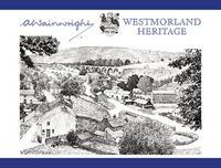
Westmorland Heritage

This magnificent book presents a detailed portrait of the buildings, the landmarks and the scenery of the old county of Westmorland. First published in 1975 to mark the incorporation of the county into Cumbria, it has been in demand ever since as both a record of a lost county, as an informed and engaging record of one of the loveliest and least spoiled parts of Britain, where nature, culture and history have combined to leave a memorable and exhilarating legacy. Every single parish is included, with its notable buildings or landscapes mapped and illustrated, and its historical or other features of interest discussed and described. Though written ”by an amateur, for amateurs” the author`s deep knowledge of and close familiarity with the countryside pervade and illuminate the
text and the two thousand line drawings.
RIP - This product is no longer available on our network. It was last seen on 25.09.2019

This page now acts as a permanent archive for this product. Add more information using the comments box below to ensure it can still be found by future generations.

Use our search facility to see if it is available from an alternative contributor.
  • External links may include paid for promotion
  • Availability: Out Of Stock
  • Supplier: Stanfords
  • SKU: 9780711224193
Availability: In Stock
£35.00

Product Description

This magnificent book presents a detailed portrait of the buildings, the landmarks & the scenery of the old county of Westmorl&. First published in 1975 to mark the incorporation of the county into Cumbria, it has been in demand ever since as both a record of a lost county, as an informed & engaging record of one of the loveliest & least spoiled parts of Britain, where nature, culture & history have combined to leave a memorable & exhilarating legacy. Every single parish is included, with its notable buildings or landscapes mapped & illustrated, & its historical or other features of interest discussed & described. Though written ”by an amateur, for amateurs” the author`s deep knowledge of & close familiarity with the countryside pervade & illuminate the text & the two thousand line drawings.

Reviews/Comments

Add New

Intelligent Comparison

Oooops!
We couldn't find anything!
Perhaps this product's unique.... Or perhaps we are still looking for comparisons!
Click to bump this page and we'll hurry up.

Price History

Vouchers

No voucher codes found.
Do you know a voucher code for this product or supplier? Add it to Insights for others to use.

Facebook

Jargon Buster

History - Anything that happens in the past. An acedemic subject.

Supplier Information

Stanfords
Stanfords was established in 1853 and opened their iconic Covent Garden flagship store in 1901. They have become the top retailer of maps, travel books and accessories in the UK and arguably offer the largest selection of maps and travel books worldwide. Famous names such as Captain Robert Falcon Scott, Ranulph Fiennes and Michael Palin have purchased from Stanfords. They now have a shop in Bristol and both stores together with other venues operate a calendar of events including talks, book signings and exhibitions. As a specialist map retailer, the map selection is comprehensive and includes road maps, street maps and walking maps from worldwide destinations, as well as a selection of world atlases and wall maps. Books include travel guides and travel literature. Stanfords also stock globes, from miniatures made of blue marble to magnificent floor-standing globes. The website features a selection of interesting articles on travel topics.
Page Updated: 2023-11-12 20:15:36

Community Generated Product Tags

Oh No! The productWIKI community hasn't generated any tags for this product yet!
Menu