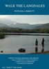
More From Contributor

£4.99
Walk the Fairfield Horseshoe by Handi Hikes is perfect for the experienced hiker as well as those new to the Lake District. This handy guide is 1 of 18 in a series of guide maps covering selected walks in the Lake District. Printed on durable compact foldaway waterproof plastic, this map

Includes::
1 moderate & 2 difficult routes & is ideal for walking & outdoor pursuits. Carry a local guide in your pocket
- carry a Handi Hike! Each Map Guide in this series

Includes::
OS 1:25, 000 Explorer mapping, accurate directions, tips on navigation & recommendations for refreshments at the end of the walks. One side the map guide shows an extract from OS explorer, accurate & easy to follow directions for the walks & a few tips on navigation. The mapping from Ordnance Survey offers a large amount of information for ramblers & tourists. All types of roads, tracks, permitted & public footpaths & bridleways are shown. Graphics & colour coding represent terrain features such as cliffs, scree, marsh, mud & vegetation. Contours are shown at 10-meter vertical intervals & spots heights are marked. A wide range of symbols locates various facilities for walkers, including youth & independent hostels, camping & caravan sites & information points. Easy to follow directions describe 3 or 4 walks in the area that are clearly marked in the map with colour coded dots. Further information

Includes::
suggested viewpoints & places for refreshments, how to link together other routes in this series as well as tips on navigation. The maps indicate whether the routes are easy, moderate or difficult. This means that you can choose a walk according to ability & mood. Walk duration & distance covered are stated. The reverse of the map guide shows the legend, reference tips on reading a grid, information on how to use a compass, as well as advice on how to stay safe in the hills. GPS compatible. All text & legends are in English only. Carry a local guide in your pocket
- carry a Handi Hike!


...
Archived Product
£4.99
Walk from the Langdale Pikes by Handi Hikes is perfect for the experienced hiker as well as those new to the Lake District. This handy guide is 1 of 18 in a series of guide maps covering selected walks in the Lake District. Printed on durable compact foldaway waterproof plastic, this map

Includes::
1 easy, 1 difficult & 2 moderate routes & is ideal for walking & outdoor pursuits. Carry a local guide in your pocket
- carry a Handi Hike! Each Map Guide in this series

Includes::
OS 1:25, 000 Explorer mapping, accurate directions, tips on navigation & recommendations for refreshments at the end of the walks. One side the map guide shows an extract from OS explorer, accurate & easy to follow directions for the walks & a few tips on navigation. The mapping from Ordnance Survey offers a large amount of information for ramblers & tourists. All types of roads, tracks, permitted & public footpaths & bridleways are shown. Graphics & colour coding represent terrain features such as cliffs, scree, marsh, mud & vegetation. Contours are shown at 10-meter vertical intervals & spots heights are marked. A wide range of symbols locates various facilities for walkers, including youth & independent hostels, camping & caravan sites & information points. Easy to follow directions describe 3 or 4 walks in the area that are clearly marked in the map with colour coded dots. Further information

Includes::
suggested viewpoints & places for refreshments, how to link together other routes in this series as well as tips on navigation. The maps indicate whether the routes are easy, moderate or difficult. This means that you can choose a walk according to ability & mood. Walk duration & distance covered are stated. The reverse of the map guide shows the legend, reference tips on reading a grid, information on how to use a compass, as well as advice on how to stay safe in the hills. GPS compatible. All text & legends are in English only. Carry a local guide in your pocket
- carry a Handi Hike!


...
Archived Product
£9.95
” Walk the Langdales” is a practical walking guidebook to twenty circular walks in the Lake District around & above Great Langdale, Little Langdale, Chapel Stile, Elterwater & Skelwith Bridge. Including all the classic high tops, the low fells & easy valley walks around lake, wood, waterfall & tarn, each walk is presented on a double page spread with clear description, excellent map, & inspirational photographs. This is the first book in the ” Walk the” series. ” Walk the Langdales” is entirely printed & produced in Cumbria. ...
Archived Product
£12.99
As a lifelong fan of London, Mark Mason embarks on a mission to 'conquer' the capital once & for all. The only way to truly discover a city, they say, is on foot. Taking this to extremes, Mark sets out to walk the entire length of the London Underground
- overground
- passing every station on the way. Over the course of several hundred miles, he comes to understand a sprawling metropolis that never ceases to surprise. In a story packed with historical trivia, personal musings & eavesdropped conversations, Mark learns how to get the best gossip in a City pub, how the Ritz made its female guests feel good about themselves, & why the Bank of England won't let you join the M11 northbound at Junction 5. He has an East End cup of tea with the Krays' official biographer, discovers what cabbies mean by 'on the cotton', & meets the Archers star who was the voice of Mind the Gap. On a broader level, Mark contemplates London's contradictions as well as its charms. He gains insights into our fascination with maps & sees how walking changes our view of the world. Above all, in this love letter to a complicated friend, he celebrates the sights, sounds & soul of the greatest city on earth.

...
Archived Product
£9.99
The only way to truly discover a city, they say, is on foot. Taking this to extremes, Mark Mason sets out to walk the entire length of the London Underground
- overground
- passing every station on the way. In a story packed with historical trivia, personal musings & eavesdropped conversations, Mark learns how to get the best gossip in the City, where to find a pint at 7am, & why the Bank of England won`t let you join the M11 northbound at Junction 5. He has an East End cup of tea with the Krays` official biographer, discovers what cabbies mean by `on the cotton`, & meets the Archers star who was the voice of ` Mind the Gap`. Over the course of several hundred miles, Mark contemplates London`s contradictions as well as its charms. He gains insights into our fascination with maps & sees how walking changes our view of the world. Above all, in this love letter to a complicated friend, he celebrates the sights, sounds & soul of the greatest city on earth.

...
Archived Product
£14.99
A composite of global cultures, Walk this World celebrates the everyday similarities as well as the exotic differences that exist between cultures around the world. Travel to a new country with every turn of the page, each with new surprises to discover: peep through windows, open doors & delve underground by opening the many lift-flaps designed into every spread. ...
Archived Product
£14.99
A composite of global cultures, Walk this World at Christmas Time celebrates the similarities, as well as the exotic differences in the way people celebrate Christmas around the globe. Travel to a new continent or country with every turn of the page, its the perfect christmas gift. ...
Archived Product
£9.99
` What is this life if, full of care, We have no time to stand & stare.`
- W.H. Davies Walking around London is one of life`s
...
Archived Product
£4.99
Walk to Blencathra by Handi Hikes is perfect for the experienced hiker as well as those new to the Lake District. This handy guide is 1 of 18 in a series of guide maps covering selected walks in the Lake District. Printed on durable compact foldaway waterproof plastic, this map

Includes::
1 moderate & 2 difficult routes & is ideal for walking & outdoor pursuits. Carry a local guide in your pocket
- carry a Handi Hike! Each Map Guide in this series

Includes::
OS 1:25, 000 Explorer mapping, accurate directions, tips on navigation & recommendations for refreshments at the end of the walks. One side the map guide shows an extract from OS explorer, accurate & easy to follow directions for the walks & a few tips on navigation. The mapping from Ordnance Survey offers a large amount of information for ramblers & tourists. All types of roads, tracks, permitted & public footpaths & bridleways are shown. Graphics & colour coding represent terrain features such as cliffs, scree, marsh, mud & vegetation. Contours are shown at 10-meter vertical intervals & spots heights are marked. A wide range of symbols locates various facilities for walkers, including youth & independent hostels, camping & caravan sites & information points. Easy to follow directions describe 3 or 4 walks in the area that are clearly marked in the map with colour coded dots. Further information

Includes::
suggested viewpoints & places for refreshments, how to link together other routes in this series as well as tips on navigation. The maps indicate whether the routes are easy, moderate or difficult. This means that you can choose a walk according to ability & mood. Walk duration & distance covered are stated. The reverse of the map guide shows the legend, reference tips on reading a grid, information on how to use a compass, as well as advice on how to stay safe in the hills. GPS compatible. All text & legends are in English only. Carry a local guide in your pocket
- carry a Handi Hike!


...
Archived Product
£4.99
Walk to Great Gable from Seathwaite by Handi Hikes is perfect for the experienced hiker as well as those new to the Lake District. This handy guide is 1 of 18 in a series of guide maps covering selected walks in the Lake District. Printed on durable compact foldaway waterproof plastic, this map

Includes::
1 moderate & 2 difficult routes & is ideal for walking & outdoor pursuits. Carry a local guide in your pocket
- carry a Handi Hike! Each Map Guide in this series

Includes::
OS 1:25, 000 Explorer mapping, accurate directions, tips on navigation & recommendations for refreshments at the end of the walks. One side the map guide shows an extract from OS explorer, accurate & easy to follow directions for the walks & a few tips on navigation. The mapping from Ordnance Survey offers a large amount of information for ramblers & tourists. All types of roads, tracks, permitted & public footpaths & bridleways are shown. Graphics & colour coding represent terrain features such as cliffs, scree, marsh, mud & vegetation. Contours are shown at 10-meter vertical intervals & spots heights are marked. A wide range of symbols locates various facilities for walkers, including youth & independent hostels, camping & caravan sites & information points. Easy to follow directions describe 3 or 4 walks in the area that are clearly marked in the map with colour coded dots. Further information

Includes::
suggested viewpoints & places for refreshments, how to link together other routes in this series as well as tips on navigation. The maps indicate whether the routes are easy, moderate or difficult. This means that you can choose a walk according to ability & mood. Walk duration & distance covered are stated. The reverse of the map guide shows the legend, reference tips on reading a grid, information on how to use a compass, as well as advice on how to stay safe in the hills. GPS compatible. All text & legends are in English only. Carry a local guide in your pocket
- carry a Handi Hike!


...
Archived Product

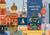
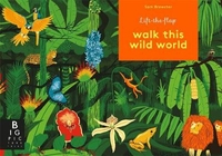
Walk This Wild World

Walk this Wild World celebrates the wondrous diversity of animal and plant life around the globe. Travel to a new habitat and continent with every turn of the page with stunning artwork by award-winning Sam Brewster. See polar bears in the Arctic tundra; elephants in the Serengeti grasslands; bobcats in the Sonoran desert; gorillas in the Congo jungle; and much more. Lift-flaps throughout this high quality format makes it a perfect gift book for all young animal-lovers, while nuggets of information on the underside of the flaps provide a gentle educational content.
RIP - This product is no longer available on our network. It was last seen on 25.09.2019

This page now acts as a permanent archive for this product. Add more information using the comments box below to ensure it can still be found by future generations.

Use our search facility to see if it is available from an alternative contributor.
  • Availability: Out Of Stock
  • Supplier: Stanfords
  • SKU: 9781783705412
Availability: In Stock
£14.99

Product Description

Walk this Wild World celebrates the wondrous diversity of animal & plant life around the globe. Travel to a new habitat & continent with every turn of the page with stunning artwork by award-winning Sam Brewster. See polar bears in the Arctic tundra; elephants in the Serengeti grasslands; bobcats in the Sonoran desert; gorillas in the Congo jungle; & much more. Lift-flaps throughout this high quality format makes it a perfect gift book for all young animal-lovers, while nuggets of information on the underside of the flaps provide a gentle educational content.

Reviews/Comments

Add New

Intelligent Comparison

Oooops!
We couldn't find anything!
Perhaps this product's unique.... Or perhaps we are still looking for comparisons!
Click to bump this page and we'll hurry up.

Price History

Vouchers

No voucher codes found.
Do you know a voucher code for this product or supplier? Add it to Insights for others to use.

Facebook

Jargon Buster

World - A physical grouping, commonly used to describe earth and everything associated with ti
Gift - Something that is presented without expecting anything in return
Quality - An object that has quality is superior in function and finish than a less quality object.

Supplier Information

Stanfords
Stanfords was established in 1853 and opened their iconic Covent Garden flagship store in 1901. They have become the top retailer of maps, travel books and accessories in the UK and arguably offer the largest selection of maps and travel books worldwide. Famous names such as Captain Robert Falcon Scott, Ranulph Fiennes and Michael Palin have purchased from Stanfords. They now have a shop in Bristol and both stores together with other venues operate a calendar of events including talks, book signings and exhibitions. As a specialist map retailer, the map selection is comprehensive and includes road maps, street maps and walking maps from worldwide destinations, as well as a selection of world atlases and wall maps. Books include travel guides and travel literature. Stanfords also stock globes, from miniatures made of blue marble to magnificent floor-standing globes. The website features a selection of interesting articles on travel topics.
Page Updated: 2023-11-12 20:15:36

Community Generated Product Tags

Oh No! The productWIKI community hasn't generated any tags for this product yet!
Menu