More From Contributor
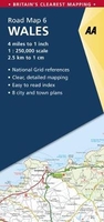
£2.95
Wales 1610 Replica Map by the Old Map Company is a reproduction of the map created for the famous atlas of the period by the master map maker John Speede Esq. The Old Map Company has recreated the antique maps of British counties, European cities & World countries originally crafted by master map maker John Speede Esq. whose work had accuracy & quality not surpassed for centuries. Each map is treated & presented on specially crafted paper then h&-treated giving it texture & an aged appearance before being beautifully engraved & detailed. ...
Archived Product
£6.99
Britain is full of fascinating & fun places to visit, these handy Days Out guides pick out 50 of the best places in Wales for family trips. The handy, compact boxes are ideal to keep in the car. Take a selection of cards out for the day & let another member of the family 'pick a card' so that the whole family can be involved in choosing what to do. Attractions featured include zoos, theme parks, galleries, steam railways, stately homes, castles & visitor centres. ...
Archived Product
£17.99
A new & uniquely accessible history of Wales. This comprehensive & authoritative companion to Wales, its people & its millennia of history can be enjoyed by armchair travellers & tourists alike. The respected historian Terry Breverton presents the characters, events, buildings & institutions that have shaped Wales over the ages, from its earliest origins to the present day. The nation has the oldest national flag in the world, one of the oldest languages in existence, the longest unbroken Christian heritage in history, & has somehow retained a fierce sense of independence & nationality despite its proximity to Engl&. The book takes us from the earliest recorded human burial in the world (at Paviland Cave) through the battles against the invading Romans, Vikings, Picts, Saxons, Normans & the Anglo-French kings to the present-day status of the country. Its people have changed the history of Britain & the United States, with the Tudor Dynasty giving Britain its European identity & Thomas Jefferson & others founding the breakaway union of American states. The book comes in an accessible, comprehensive, illustrated dictionary format, from an author who has written more than twenty entertaining & informative books upon the Welsh & their achivements. ...
Archived Product
£5.95
Wales Road Atlas at 1:158, 400 (1” to 2.5 miles) from A-Z, with town centre street plans of Cardiff, Aberystwyth, Bangor, Caernarfon, Carmarthen, Chester, Colwyn Bay, Hereford, Llandudno, Llanelli, Merthyr Tydfil, Newport, Prestatyn, Rhyl, Shrewsbury, Swansea & Wrexham, plus enlargement showing in greater detail access to Cardiff International Airports & the ferry terminals in Fishguard, Holyhead & Pembroke Dock. Current edition was published in 2015. Mapping in this regional series from A-Z has clear presentation of the road network, topographic information, places of interest, etc. Publishers’ cartography used in their 5 miles to 1” series is enlarged here to make local roads more prominent & provides all the standard motoring information: services, primary route destinations, toll barriers, gradients, locations of petrol stations & speed cameras, etc. Railway lines are shown with stations. Topography is indicated by colouring & relief shading for areas above 400 feet (122 metres), with additional colouring for woodlands. A wide range of symbols highlight various places of interest. Each title has British National Grid lines & is indexed. Selected regions are also covered by A5, paperback road atlases with the same cartography slightly enlarged, so with place names in larger print. The atlases include town centre street plans of main cities – for details please see individual descriptions. To see the list of titles in this series please click on the series link. ...
Archived Product
£5.95
Wales on an indexed road map at 1:221, 760 (1” to 3.5 miles) from A-Z. Coverage extends north to include Liverpool & the Merseyside & south-east to Bristol & Weston-super-Mare. The index is on the reverse. Current edition was published in 2015. Mapping in this regional series from A-Z has clear presentation of the road network, topographic information, places of interest, etc. Publishers’ cartography used in their 5 miles to 1” series is enlarged here to make local roads more prominent & provides all the standard motoring information: services, primary route destinations, toll barriers, gradients, locations of petrol stations & speed cameras, etc. Railway lines are shown with stations. Topography is indicated by colouring & relief shading for areas above 400 feet (122 metres), with additional colouring for woodlands. A wide range of symbols highlight various places of interest. Each title has British National Grid lines & is indexed. Selected regions are also covered by A5, paperback road atlases with the same cartography slightly enlarged, so with place names in larger print. The atlases include town centre street plans of main cities – for details please see individual descriptions. To see the list of titles in this series please click on the series link. ...
Archived Product
£11.99
Wales is a nation with every conceivable holiday attraction you could wish for. Even if you spent a year trying, you wouldn't see half of its castles or dolmens. Yet for all its remarkable history, this is a country that always looks forward, embracing re-invention while maintaining its original charm. The AA Guide to Wales gives you all you need to know to get the most out of your visit to this wonderful l&. From the roar of the Millennium Stadium to the hushed delights of a Hay-on-Wye bookshop, climbing in Snowdonia to going underground at the National Pit Museum, each entry is packed with the very best sites to see, things to do, recommendations for eating & drinking, & places to explore nearby. With everything from local legends to must-see festivals & events, this authoritative & practical guide ensures you will never be lost for something to do. ...
Archived Product
£17.99
A beautifully illustrated history of Wales from prehistory to the present day. Wales is a small country with a great history. A highly distinguished team of historians tell the story of Wales from the formation of the land to the development of modern Wales as a vibrant, twenty-first-century state. ...
Archived Product
£34.95
Wales & the Midlands Postcode District Map at 1:320, 000, encapsulated version, in a series of postcode district maps from Map Marketing showing the boundaries of the first half of the postcode (or the Outward Code). Enlargements show Birmingham, Bristol, Liverpool & Cardiff in greater detail. Coverage extends north to Preston, south to Bath, & east to Northampton. Map Marketing’s series of postcode district maps covers Great Britain on six titles, each available only as a flat map, either on paper or encapsulated for greater durability. The Area & District boundaries are shown in red, with County & Unitary Authority boundaries displayed in violet. The map base shows motorways plus primary, ‘A’ & ‘B’ roads, & features conurbation shapes highlighting major towns & cities. The maps include all of the postcode changes from the most recent Royal Mail Postcode Update. Some district sheets also contain large scale city plans within the sheet’s catchment area. To see the list of all the titles in this series please click on the series link.LAMINATED & ENCAPSULATED WALL MAPS:- LAMINATED wall maps have a thin layer of plastic usually applied to the printed side only. They can be written on with suitable marker pens without any damage to the map but, unless laminated on both sides, they are not damp-proof.- ENCAPSULATED wall maps are sealed between two sheets of plastic. They are more rigid & heavier than laminated maps of the same size. They are damp-proof & do not crinkle in humid conditions. Encapsulation gives the map a shiny surface, similar to being displayed behind glass.- PLEASE NOTE: many publishers & retailers often use these two terms interchangeably. Our map titles & descriptions follow the definitions provided above. ...
Archived Product
£24.95
Wales & the Midlands Postcode District Map at 1:320, 000, paper version, in a series of postcode district maps from Map Marketing showing the boundaries of the first half of the postcode (or the Outward Code). Enlargements show Birmingham, Bristol, Liverpool & Cardiff in greater detail. Coverage extends north to Preston, south to Bath, & east to Northampton. Map Marketing’s series of postcode district maps covers Great Britain on six titles, each available only as a flat map, either on paper or encapsulated for greater durability. The Area & District boundaries are shown in red, with County & Unitary Authority boundaries displayed in violet. The map base shows motorways plus primary, ‘A’ & ‘B’ roads, & features conurbation shapes highlighting major towns & cities. The maps include all of the postcode changes from the most recent Royal Mail Postcode Update. Some district sheets also contain large scale city plans within the sheet’s catchment area. To see the list of all the titles in this series please click on the series link. ...
Archived Product
£14.95
This guidebook explores the Welsh Coast Path which, at 1408km, is the longest trail in Britain, as it traces the coastline from Chester to Chepstow. This guide divides the Path into 9 geographical areas & 57 stages, ranging between 15 to 32km in length. The names of Anglesey, the Llyn Peninsula, Cardigan Bay, Pembrokeshire, & the Gower conjour ideas of spectacular scenery, world-famous geology, seabirds & wildlife, all of which can be explored with this guide. Opened in 2012, the entire coast is now accessible & waymarked; a true adventure along some of the best coastline in the British Isles. Full of variety; from cities & castles to sandy beaches, tiny harbours to the crash of waves against rugged cliffs, the Path offers new sights at every point. Never straying far from the sea, or climbing higher than 300m, the Path can nevertheless offer strenuous walking as well as gentle rambles. Alongside detailed route descriptions & maps for each stage, the guidebook provides a range of practical information, whether you plan to walk the Path in full, or as a series of day-walks. Travel information, advice on accommodation & planning, as well as details on the history, wildlife & geology of the coast ensure that this is an ideal companion to uncovering the Welsh coast on foot. ...
Archived Product

Wales AA Road Map

Britain`s clearest mapping from the experts at the AA, in a handy foldable road map covering Wales. Fully updated, the map combines clear design and an easy-to-read scale of 3 miles to 1 inch, with more road detail to ensure you never lose your way while navigating Britain`s roads. The map includes information on toll points, service areas, road numbers, motorways, dual carriageways and wide and narrow local roads. National parks and places of interest are also highlighted.
RIP - This product is no longer available on our network. It was last seen on 25.09.2019

This page now acts as a permanent archive for this product. Add more information using the comments box below to ensure it can still be found by future generations.

Use our search facility to see if it is available from an alternative contributor.
  • External links may include paid for promotion
  • Availability: Out Of Stock
  • Supplier: Stanfords
  • SKU: 9780749578947
Availability: In Stock
£4.99

Product Description

Britain`s clearest mapping from the experts at the AA, in a handy foldable road map covering Wales. Fully updated, the map combines clear design & an easy-to-read scale of 3 miles to 1 inch, with more road detail to ensure you never lose your way while navigating Britain`s roads. The map

Includes::
information on toll points, service areas, road numbers, motorways, dual carriageways & wide & narrow local roads. National parks & places of interest are also highlighted.

Reviews/Comments

Add New

Intelligent Comparison

Oooops!
We couldn't find anything!
Perhaps this product's unique.... Or perhaps we are still looking for comparisons!
Click to bump this page and we'll hurry up.

Price History

Vouchers

No voucher codes found.
Do you know a voucher code for this product or supplier? Add it to Insights for others to use.

Facebook

Jargon Buster

Inch - Equivalent to approximately 2.5cm
Road - a manmade lane or a path that is used to speed up travel.
Wide - Something with a large width.
Design - A drawing or styles that shows the look and functionality of something before its made.

Supplier Information

Stanfords
Stanfords was established in 1853 and opened their iconic Covent Garden flagship store in 1901. They have become the top retailer of maps, travel books and accessories in the UK and arguably offer the largest selection of maps and travel books worldwide. Famous names such as Captain Robert Falcon Scott, Ranulph Fiennes and Michael Palin have purchased from Stanfords. They now have a shop in Bristol and both stores together with other venues operate a calendar of events including talks, book signings and exhibitions. As a specialist map retailer, the map selection is comprehensive and includes road maps, street maps and walking maps from worldwide destinations, as well as a selection of world atlases and wall maps. Books include travel guides and travel literature. Stanfords also stock globes, from miniatures made of blue marble to magnificent floor-standing globes. The website features a selection of interesting articles on travel topics.
Page Updated: 2023-11-12 20:15:36

Community Generated Product Tags

Oh No! The productWIKI community hasn't generated any tags for this product yet!
Menu