
 United Kingdom
 France
 Germany
 Netherlands
 Sweden
 USA
USA
 Italy
Italy
 Spain
Spain
More From Contributor


Virunga Trivet Small Soft Gold
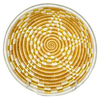
The sunburst pattern on these baskets is known as the “hope” design. Reflected on the Rwandan flag, this sunburst images stands for the county’s collective hope for a new dawn and brighter future. This design means a lot to the weavers we partner with, as each basket they sell increases their chances for a better life.This heat resistant trivet is perfect to set a tea kettle on or hot dish from the oven. With a woven loop attached on the back, they can be hung up as wall decor for a globally inspired feel.When you purchase these handcrafted goods from Kazi Goods (All Across Africa), you are creating opportunities for men and women across Africa to thrive. It’s that simple. Inspired living, opportunities to thrive. Go ahead, take in your love for the world every day and share
in the delight of connecting with African artisans. Kazi Goods reaches deep into rural villages in the developing world and provides training and fair wage jobs that restore dignity and promote self-sufficiency - the way forward for sustainable development in Africa.They re-invest profits to further expand artisan development through artisan training; by training rural farmers to become artisans who then teach existing craftsmen new techniques to expand markets. Additionally, their teams provide education on finance, business management and leadership to empower men and women throughout the entire value chain.Artful craftsmanship that does good.Specifications:- Care Instructions:- Meaning & Purpose:- Approximately 10” D x 0.5” H- Made in Rwanda- Product is made from all natural
fibers of sisal and sweet grass- Organic dyes are used to dye the sisal- Profiled weaver tag is attached to each product- Trivet has a hang loop on the back for wall décor- Safe to use with food*All products are made by hand with love and vary slightly in color and size.Made only in an ethical, fair trade environment. Handwoven by a cooperative of women located in Rwanda, this one of kind piece takes weeks to complete.
Product Description
Reviews/Comments
Add New
Vouchers
No voucher codes found.
Do you know a voucher code for this product or supplier? Add it to Insights for others to use.
Do you know a voucher code for this product or supplier? Add it to Insights for others to use.
 Denmark