
 United Kingdom
 France
 Germany
 Netherlands
 Sweden
 USA
USA
 Italy
Italy
 Spain
Spain
More From Contributor


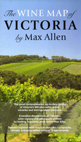
Victoria Wine Map
Victoria Wine Map by Max Allen is a comprehensive, double sided, indexed mapping and listing of Victoria’s 900 plus cellar doors, wineries and vineyards, with an enlarged map of the Port Philip region filling up one side of the sheet. Descriptions of the area’s wine regions and sub regions have been written by leading Australian wine writer Max Allen and additional regional wine maps of Victoria’s topography, climate and most widely-planted grape varieties. Vineyards, wineries and cellar doors open and not open to the public are marked on the map which features key motoring navigation information such as the divided highways, primary, secondary, and minor sealed and unsealed roads, as well as trails. As well as town names, National Parks, Wilderness Parks, State Parks,
Forests and Conservation Reserves are indicated. Some colour relief shading is shown and the locations and names of significant peaks are given. Administrative boundaries are marked. Lines of latitude and longitude are given at 15’ intervals.
Forests and Conservation Reserves are indicated. Some colour relief shading is shown and the locations and names of significant peaks are given. Administrative boundaries are marked. Lines of latitude and longitude are given at 15’ intervals.

Product Description
Reviews/Comments
Add New
Vouchers
No voucher codes found.
Do you know a voucher code for this product or supplier? Add it to Insights for others to use.
Do you know a voucher code for this product or supplier? Add it to Insights for others to use.
 Denmark