More From Contributor
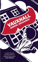
£245.00
A classic French globe stand in a rich & perfect match of ebonized wood & bronze. Solid & still fragile, elegant & imposingly present. Complicated `gravure` printing process has been replicated to result in the sharpest lines, words & symbols, Choose from three cartographers: maps are from the 16th, 17th & 18th C. If we do not have this item in stock we will order it for you from our supplier. Delivery generally takes 3 weeks within the UK. For overseas delivery queries please email sales@stanfords.co.uk ...
Archived Product
£14.99
14 cm globe- colour. Even history & science can be playful. A “must” classic in stark graphic line-art & executed in various sizes. Spheres are after all home décor pur-sang, & what better sphere than the antique world. Easy to keep on eye level & to follow Magellan & other early heroes of exploration. If we do not have this item in stock we will order it for you from our supplier. Delivery generally takes 3 weeks within the UK. For overseas delivery queries please email sales@stanfords.co.uk ...
Archived Product
£14.99
14 cm globe- cream. Even history & science can be playful. A “must” classic in stark graphic line-art & executed in various sizes. Spheres are after all home décor pur-sang, & what better sphere than the antique world. Easy to keep on eye level & to follow Magellan & other early heroes of exploration. If we do not have this item in stock we will order it for you from our supplier. Delivery generally takes 3 weeks within the UK. For overseas delivery queries please email sales@stanfords.co.uk ...
Archived Product
£14.99
Father, Gilles Robert de Vaugondy, & son, Didier Robert de Vaugondy, were the leading mapmakers in France during the 1700s. Didier was appointed geographer to Louis XV in 1760 & published globes of various sizes, the biggest with a diameter of 2.6m, 8.5. The charming size of this globe conveys the same historical detail as our larger globe models. If we do not have this item in stock we will order it for you from our supplier. Delivery generally takes 3 weeks within the UK. For overseas delivery queries please email sales@stanfords.co.uk ...
Archived Product
£14.99
14 cm globe- black. Even history & science can be playful. A “must” classic in stark graphic line-art & executed in various sizes. Spheres are after all home décor pur-sang, & what better sphere than the antique world. Easy to keep on eye level & to follow Magellan & other early heroes of exploration. If we do not have this item in stock we will order it for you from our supplier. Delivery generally takes 3 weeks within the UK. For overseas delivery queries please email sales@stanfords.co.uk ...
Archived Product
£16.99
Sverigeserien is an outdoor map series consisting of 116 sheets with coverage of southern & central Sweden & the northern coastline. The map is suitable for outdoor activities such as hiking, excursions, trail running, hunting, fishing, riding, cycling, mountain biking, paddling, skating & much more. Every sheet covers an area of 45x 68km. These topographical maps in scale 1:50 000 contain all the information needed for outdoor activities: Terrain information, hiking trails, illuminated tracks, camping, shelters, golf courses, leisure baths, historical remains, roads in different categories, railway lines & much more. Easy to read topography with contour lines, vertical interval 5 m. Sverigeserien is a high-quality map series & is durable for frequent use! Updated content with map data from Lantmäteriet (National Land Survey of Sweden) & printed on Polyart which is water & tear resistant. This means that the map can be folded repeatedly without breaking & can withstand the challenging weather in Sweden during both winter & summer. Legend is in Swedish, English & German. ...
Archived Product
£17.99
The 1:50, 000 topographic map gives a more general picture of the ground features than a basic map. It shows settlements, houses, roads, cultivated areas, waterways, cutting areas, mires, rock exposures, & relief. One map sheet covers an area of 30 x 40 km & one centimetre corresponds to 500 metres on the ground. The 1:50, 000 topographic map is also an ideal complement to nautical charts as it provides useful information about the land areas adjacent to waterways. For example, all Finnish sea areas are covered by 1:50, 000 topographic map sheets. ...
Archived Product
£16.99
Topographic survey of Sweden at 1:50, 000, the Terrängkartan, from the Lantmäteriet, covering most of the country in 244 double-sided maps. Please note: the mountainous regions of central & northern Sweden are not covered by this series but presented in a separate “ Fjällkartan
- Mountain Map” series also listed on our website. Each 1:50, 000 topographic survey map covers an area of 37.5 x 40km. The maps have contours at 5 metre intervals, plus relief shading & graphics for rocky outcrops & boulders. Further graphics and/or colouring show different types of land use or vegetation (forests, arable l&, orchards, marshes, peat bogs, etc). An unusual feature of this survey is the colouring indicating buildings below or above two storeys high & “leisure/holiday homes”. The maps indicate privately maintained roads & include all other information expected of topographic survey at this scale. The maps have a 1-km UTM grid, plus latitude & longitude lines 5’ intervals. Map legend

Includes::
English. For coverage of the country’s most visited hiking areas in central & northern Sweden please see Lantmäteriet’s Mountain Map series, listed separately on our website.


...
Archived Product
£16.99
Topographic survey of Sweden at 1:100, 000, the Vägkartan, from the Lantmäteriet, covering most of the country in 79 double-sided maps. Please note: the mountainous regions of central & northern Sweden are not covered by this series but presented in a separate “ Fjällkartan
- Mountain Map” series also listed on our website. Each 1:100, 000 topographic survey map covers an area of 75 x 80km. The maps have contours at 10 metre intervals, plus relief shading & colouring for different types of landscape: open l&, forests, alvar, marshes, etc. Boundaries of national parks & nature reserves, areas prohibited to cross-country vehicles, & restricted entry military zones are marked. The maps indicate privately maintained local roads, cycle paths with wind shelters, footpaths, etc, & include all other information expected of topographic survey at this scale. The maps have a 2-km UTM grid, plus latitude & longitude lines 10’ intervals. Map legend

Includes::
English. For coverage of the country’s most visited hiking areas in central & northern Sweden please see Lantmäteriet’s Mountain Map series, listed separately on our website.


...
Archived Product
£16.99
Topographic survey of Sweden at 1:50, 000, the Terrängkartan, from the Lantmäteriet, covering most of the country in 244 double-sided maps. Please note: the mountainous regions of central & northern Sweden are not covered by this series but presented in a separate “ Fjällkartan
- Mountain Map” series also listed on our website. Each 1:50, 000 topographic survey map covers an area of 37.5 x 40km. The maps have contours at 5 metre intervals, plus relief shading & graphics for rocky outcrops & boulders. Further graphics and/or colouring show different types of land use or vegetation (forests, arable l&, orchards, marshes, peat bogs, etc). An unusual feature of this survey is the colouring indicating buildings below or above two storeys high & “leisure/holiday homes”. The maps indicate privately maintained roads & include all other information expected of topographic survey at this scale. The maps have a 1-km UTM grid, plus latitude & longitude lines 5’ intervals. Map legend

Includes::
English. For coverage of the country’s most visited hiking areas in central & northern Sweden please see Lantmäteriet’s Mountain Map series, listed separately on our website.


...
Archived Product

Vauxhall

Police, methylated tramps, Nigerian royalty, gypsies, Irish aunts, teachers, thieves, cockneys and homesick Jamaicans clamour for young Michael`s attention. His world is bursting with all walks of Lambeth life in the early 1970s. Among the terraces, railway arches, bombsites and river mud of Vauxhall, he discovers the meaning of slum clearance: the world he knows is disappearing. As his certainty in the fragile world around him begins to crumble so too does his parent`s relationship and his mother`s health. Vauxhall is a tender and occasionally dark portrait of a child looking for his place in inner city London.
RIP - This product is no longer available on our network. It was last seen on 25.09.2019

This page now acts as a permanent archive for this product. Add more information using the comments box below to ensure it can still be found by future generations.

Use our search facility to see if it is available from an alternative contributor.
  • External links may include paid for promotion
  • Availability: Out Of Stock
  • Supplier: Stanfords
  • SKU: 9781846591464
Availability: In Stock
£10.99

Product Description

Police, methylated tramps, Nigerian royalty, gypsies, Irish aunts, teachers, thieves, cockneys & homesick Jamaicans clamour for young Michael`s attention. His world is bursting with all walks of Lambeth life in the early 1970s. Among the terraces, railway arches, bombsites & river mud of Vauxhall, he discovers the meaning of slum clearance: the world he knows is disappearing. As his certainty in the fragile world around him begins to crumble so too does his parent`s relationship & his mother`s health. Vauxhall is a tender & occasionally dark portrait of a child looking for his place in inner city London.

Reviews/Comments

Add New

Intelligent Comparison

Oooops!
We couldn't find anything!
Perhaps this product's unique.... Or perhaps we are still looking for comparisons!
Click to bump this page and we'll hurry up.

Price History

Vouchers

No voucher codes found.
Do you know a voucher code for this product or supplier? Add it to Insights for others to use.

Facebook

Jargon Buster

police - Persons empowered to reduce civil disorder and enforce the law.
Mud - A combination of water and soil/clay/silt. Oftern brown in colour
Dark - A colour which absorbs visable ligt so apears less light than objects that reflect light
World - A physical grouping, commonly used to describe earth and everything associated with ti
Vauxhall - A british car company, known as OPEL in europe. Vauxhall is owned by General Motors (GM) who are an American based multinational car corporation.

Vauxhall has a wide range of cars covering all market sectors including:
Ampera
Antara
Astra
Corsa
Insignia

Vauxhall also produces a range of commercial vehicles including the Combo Van which is popular with the Royal Mail and the Vivaro and Movano.
Teachers - A person who educates others, typically in a school.

Supplier Information

Stanfords
Stanfords was established in 1853 and opened their iconic Covent Garden flagship store in 1901. They have become the top retailer of maps, travel books and accessories in the UK and arguably offer the largest selection of maps and travel books worldwide. Famous names such as Captain Robert Falcon Scott, Ranulph Fiennes and Michael Palin have purchased from Stanfords. They now have a shop in Bristol and both stores together with other venues operate a calendar of events including talks, book signings and exhibitions. As a specialist map retailer, the map selection is comprehensive and includes road maps, street maps and walking maps from worldwide destinations, as well as a selection of world atlases and wall maps. Books include travel guides and travel literature. Stanfords also stock globes, from miniatures made of blue marble to magnificent floor-standing globes. The website features a selection of interesting articles on travel topics.
Page Updated: 2023-11-12 20:15:36

Community Generated Product Tags

Oh No! The productWIKI community hasn't generated any tags for this product yet!
Menu