More From Contributor
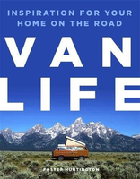
£6.50
Topographic coverage of the Canary Islands at 1:25, 000 published by the Instituto Geográfico Nacional – Centro Nacional de Información Geografica, the country’s civilian survey organization. The maps have contours at 10m intervals & colouring and/or graphics to show different types of vegetation or land use. Boundaries of national parks & other protected areas are marked. In addition to all the usual information shown on topographic mapping at this scale: detailed presentation of the road network with rural tracks & paths, etc, the maps also show campsites. The maps have a 1-km UTM grid, plus margin ticks for latitude & longitude at 1` intervals. The majority of the titles have been published since late 1990s. Map legend is in Spanish only.COVERAGE: each 25K map covers one quarter of the corresponding 1:50, 000 map, with the numbering system: I = NW quarter, II = NE quarter, III = SW quarter, & IV = SE quarter. To see other titles in this series please click on the series link. ...
Archived Product
£6.95
Topographic coverage of mainland Spain at 1:50, 000 in the MTN50 (Mapa Topográfico Nacional) series from the Centro Nacional de Información Geografica, the country’s civilian survey organization. The maps have contours at 20m intervals, enhanced by relief shading, plus colouring and/or graphics to show different types of terrain, vegetation or land use. Boundaries of national parks & other protected areas are marked. In addition to all the usual information featured on topographic mapping at this scale, detailed presentation of the road & rail networks, rural tracks & paths, etc, the maps also show campsites & mountain refuges. On more recent editions some GRs, the official long-distance hiking routes, are also marked (although not as clearly as on hiking maps from other publishers). Each map covers 29.5x 18.5 km (with adjustments in the border or coastal areas). The maps have a 1-km UTM grid, plus margin ticks for latitude & longitude at 1` intervals. Map legend is in Spanish only.HOW TO CHOOSE THE RIGHT 50K MAP: all the titles in CNIG’s 200K Provincial Road Maps series at 1:200, 000 are overprinted with the grid for the 1:50, 000 maps & can be used to see the area covered by each 50K title. TO SEE THE LIST OF TITLES IN THIS SERIES PLEASE CLICK ON THE SERIES LINK.PLEASE NOTE
- MAP TITLES: the grids shown on our website serve both the civilian & the military 1:50, 000 topographic series. Although the areas covered by maps in both series are identical (apart from some border or coastal sheets), occasionally map titles differ – only one title is shown on the grid, usually the military one. In Galicia, the Basque country & in the Catalan speaking areas the tendency now is to use local place names rather than the often better known Castilian ones. Where possible, both versions are included in our titles. Map titles listed on our website are based on information received by us at the time of publication, but sometimes maps arrive showing a completely different title! As long as the map number is as ordered, the correct map has been supplied.
...
Archived Product
£12.99
Gathered for the first time in English & spanning his entire career, Vampire in Love offers a selection of the Spanish master Enrique Vila-Matas`s finest short stories. An effeminate, hunchbacked barber on the verge of death falls in love with a choir boy. A fledgling writer on barbiturates visits Marguerite Duras`s Paris apartment & watches his dinner companion slip into the abyss. An unsuspecting man receives a mysterious phone call from a lonely ophthalmologist & visits his abandoned villa. The stories in Vampire in Love, selected & brilliantly translated by Margaret Jull Costa, are all told with Vila-Matas`s delightful erudition & wit, & his provocative questioning of the interrelation of art & life. ...
Archived Product
£15.00
Early in his career, as he grappled with the idea of becoming an artist, Vincent van Gogh attempted portraiture, possibly with a mission in the religious sense. His models were impoverished miners, weavers & peasants. Later, his great achievement was in still life, landscape painting & further portraits all closely related to the places where he lived. He moved from place to place, from his parents` vicarage to the homes of impoverished peasants, from seaside Ramsgate, & landmarks in London to the heights of Montmartre, from the famous Yellow House in Arles to hospital then a nearby asylum. Finally, he wandered the fields & streets of Auvers, near Paris. Wherever he lived, he drew & painted. As well as the places where he stayed, he painted the homes of others, & monuments that attracted him, such as churches or even suburban factories. These became the subject of an alternative kind of portraiture
- one that did not involve people. His developing, emphatic & highly individual style suited the different character of the buildings he so carefully recorded. Each place, about which he also wrote at length, provides us with a solid framework with which to follow & understand him. Van Gogh`s life will be revealed not only through the included illustrations of his art, but with much"ation from letters. The book hopes to answer the questions: Why was he there? what & who else were there? How did his vision suit the place
- or vice versa?

...
Archived Product
£11.99
In December 1888, Vincent van Gogh cut off his ear. It is the most famous story about any artist in history. But what really happened on that dark winter night? In Van Gogh`s Ear, Bernadette Murphy reveals the truth. She takes us on an extraordinary journey from major museums to forgotten archives, vividly reconstructing Van Gogh`s world. We meet police inspectors & cafe patrons, prostitutes & madams, his beloved brother Theo & fellow painter Paul Gauguin. Why did Van Gogh commit such a brutal act? Who was the mysterious ` Rachel` to whom he presented his macabre gift? Did he really remove his entire ear? Murphy answers these important questions with her groundbreaking discoveries, offering a stunning portrait of an artist edging towards madness in his pursuit of excellence. BBC RADIO 4 BOOK OF THE WEEK PRIMETIME BBC2 DOCUMENTARY WITH JEREMY PAXMAN. ...
Archived Product
£17.99
One of the titles in the topographic survey of the Svalbard group published in a colour version, available for the western coast, central & southern part of Spitzbergen, plus two small islands of Svenskøya & Kongsøya. The map has contours at 25-metre intervals, bold relief shading & spot heights, & shows settlements, roads & tracks, working & disused mines, airfields, lighthouses & radio beacons, etc. A grid gives UTM co-ordinates plus latitude in steps of 10` & longitude in 20’. The rest of Spitzbergen, Nordaustlandet, Edgeøya & other small islands are covered by black & white maps with contours only. Most of these maps show no geographical names, as indicated in the individual descriptions of each title. ...
Archived Product
£8.99
” Portugal is not all that far away, or exotic, or dangerous, but it felt like a huge stretch for me to leave my partner, family, job & home & just go off. An overland solo trip lasting months in an ancient little campervan was not the kind of thing I did. But it was something I was about to do.” In her debut memoir A Van of One`s Own, Biddy Wells tells the story of how, propelled by a thirst for peace & quiet, for a modest adventure &, perhaps, for freedom, she left for Portugal on her own, with only her old campervan, Myfawny, & her GPS, Tanya, for company. Having left just about everything behind, her solo trip forces her to face her fears, her past, & herself. The road provides the perfect canvas to connect the dots between a past breakdown & her present need for freedom, as she reflects on her own life, her relationship, her family & the world around her
- to see whether her life still has room for her in it. As she meets wise & not-so- wise people, members of the campervan community & friendly locals, her outlook on life begins to shift, & a chance meeting in a bar leads to the person who will put her on the right track. But will she go back home, to Wales? And what is the meaning of `home?`A Van of One`s Own is a journey through the breath-taking scenery of France, Spain, & finally Portugal, populated by colourful characters & the roar of the ocean, the taste of fresh fish & the grind of the asphalt; but more importantly, it is a journey through past memories & present conflicts to inner peace.
...
Archived Product
£8.95
Excellent, double-sided, waterproof map of the city & downtown, with greater Vancouver on the reverse. The plan of Vancouver is at 1:20, 000 & is indexed for streets & places of interest. The clear road detail

Includes::
one-way restrictions & shows bicycle routes, trolleybus & bus routes & stations. Passenger ferry routes are shown, also the floatplane terminal, railways & commuter train, underground & Skytrain lines & stations. Colours distinguish parks, industrial areas, institutions & shopping areas, & there is an indication of block numbers. A range of symbols show various services & landmarks, eg. petrol stations, information centres, accommodation, post offices, beaches, golf courses, places of worship, museums, galleries & other places of interest. An inset at 1:12, 500 shows the Downtown/ West End district in greater detail. On the reverse the coverage extends beyond the Vancouver city limits with a 1:50, 000 map of Greater Vancouver which

Includes::
North Vancouver in the north, Burns Bog in the south, the international airport, & Pitt Meadows in the east. This map is not indexed but identifies main roads & shows the railways, ferries, municipal boundaries, regional parks, built-up areas, green spaces & other useful details.


...
Archived Product
£6.99
The National Geographic map of Vancouver at 1:13, 700 is a durable waterproof city map & transport guide designed for tourism. Clear & easy-to-read street mapping has main attractions highlighted & 3D illustrations of top sights. Hotels, churches, theatres & information points are among the tourist features marked on the map. One-way streets & pedestrian areas are indicated. The map covers from Hollyburn (West Vancouver) in the north-west, to Mount Pleasant & Strathcona in the south-east. Small enlargements on the reverse show Victoria (British Columbia) & Granville Isl&. The reverse of the map features background information, top sights & activities, basic essential tourist info & city transport network details, as well as a small map of Vancouver International Airport showing terminals & transport connections. The map is indexed for streets, points of interest & hotels, &

Includes::
regional & national overview maps. This map is printed on a surprisingly strong rip-proof, waterproof paper.

...
Archived Product
£10.39
Vancouver in the Countries, Regions & Cities series from Rough Guides; comprehensively detailed guidebooks specifically designed for independent travellers & serving a range of worldwide destinations. Widely recognised for their free editorial style, Rough Guide authors are allowed to express their personal opinions on a range of subjects. Although sometimes controversial, this editorial stance allows readers to experience more detailed & personal takes on each destination, a feature often more limited in other guidebooks. Cultural & historical nuances are explored in significant depth throughout the text & descriptions on the ambience of individual settings alongside personal recommendations, particularly in cities, are notably prevalent. Each Rough Guide in the Countries, Regions & Cities series has a similar layout. A ...
Archived Product

Van Life

More and more people are taking a break from conventional life for the freedom and adventure of being on the road and living in a converted vintage truck, camper, or van.One of these vandwellers, Foster Huntington, created the vanlife hashtag as he chronicled his adventures living in a van while driving across country. He tapped into a community of like-minded individuals looking to explore nature at their own pace.VAN LIFE showcases the best crowd-sourced photographs of stunning beaches, misty forests, and rocky mountains from Foster`s tumblr account, many of which have never been posted.
RIP - This product is no longer available on our network. It was last seen on 25.09.2019

This page now acts as a permanent archive for this product. Add more information using the comments box below to ensure it can still be found by future generations.

Use our search facility to see if it is available from an alternative contributor.
  • External links may include paid for promotion
  • Availability: Out Of Stock
  • Supplier: Stanfords
  • SKU: 9780751570274
Availability: In Stock
£16.99

Product Description

More & more people are taking a break from conventional life for the freedom & adventure of being on the road & living in a converted vintage truck, camper, or van. One of these vandwellers, Foster Huntington, created the vanlife hashtag as he chronicled his adventures living in a van while driving across country. He tapped into a community of like-minded individuals looking to explore nature at their own pace.VAN LIFE showcases the best crowd-sourced photographs of stunning beaches, misty forests, & rocky mountains from Foster`s tumblr account, many of which have never been posted.

Reviews/Comments

Add New

Intelligent Comparison

Oooops!
We couldn't find anything!
Perhaps this product's unique.... Or perhaps we are still looking for comparisons!
Click to bump this page and we'll hurry up.

Price History

Vouchers

No voucher codes found.
Do you know a voucher code for this product or supplier? Add it to Insights for others to use.

Facebook

Jargon Buster

Adventure - an undertaking of an exciting challenge or experience.
Road - a manmade lane or a path that is used to speed up travel.
Vintage - An older product that has become more quirky with time.

Supplier Information

Stanfords
Stanfords was established in 1853 and opened their iconic Covent Garden flagship store in 1901. They have become the top retailer of maps, travel books and accessories in the UK and arguably offer the largest selection of maps and travel books worldwide. Famous names such as Captain Robert Falcon Scott, Ranulph Fiennes and Michael Palin have purchased from Stanfords. They now have a shop in Bristol and both stores together with other venues operate a calendar of events including talks, book signings and exhibitions. As a specialist map retailer, the map selection is comprehensive and includes road maps, street maps and walking maps from worldwide destinations, as well as a selection of world atlases and wall maps. Books include travel guides and travel literature. Stanfords also stock globes, from miniatures made of blue marble to magnificent floor-standing globes. The website features a selection of interesting articles on travel topics.
Page Updated: 2023-11-12 20:15:36

Community Generated Product Tags

Oh No! The productWIKI community hasn't generated any tags for this product yet!
Menu