
 United Kingdom
 France
 Germany
 Netherlands
 Sweden
 USA
USA
 Italy
Italy
 Spain
Spain
More From Contributor


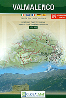
Valmalenco
Valmalenco on a double-sided, contoured and GPS compatible map at 1:25, 000 from Litografia Artistica Cartografica in their Global Map imprint. Coverage extends from Sondrio and the Adda River northwards to beyond the Swiss border and includes Monte Disgrazia, Pizzo Scalino and the peak of Bernina with the surrounding glaciers.The map has contours at 20m intervals, enhanced by shading and excellent graphic relief for rocky areas, plus colouring for woodlands and glaciers. Local hiking paths are prominently highlighted, indicating where appropriate their numbers, and graded according to the degree of difficulty. Also highlighted are locations of alpine huts and refuges, showing if opened throughout the year. Funiculars and ski lifts are marked. The map has latitude and longitude grid
at intervals of 1’. Map legend includes English.
at intervals of 1’. Map legend includes English.

Product Description
Reviews/Comments
Add New
Intelligent Comparison
Archived Product
Valenca Stanfords
£17.99
Archived Product

Valence Stanfords
£6.99
Archived Product
Valence Stanfords
£11.50
Archived Product
Valenca Stanfords
£17.99
Archived Product
Valenca Stanfords
£17.99
Vouchers
No voucher codes found.
Do you know a voucher code for this product or supplier? Add it to Insights for others to use.
Do you know a voucher code for this product or supplier? Add it to Insights for others to use.
 Denmark