More From Contributor
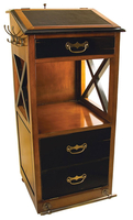
£4.95
Valencia in the Wallpaper City Guide series, published by Phaidon & encompassing a collection of pocket-size guides dedicated to the best design elements in major cities. Compiled by experts at the Wallpaper magazine, the guides are widely recognized for appealing to design-conscious travellers & are aimed at those interested in art, design & architecture. Each guide identifies the best bars, restaurants, hotels, places to shop, leisure activities & excursions with a unique emphasis on the finest examples of unusual architecture & design. Each Wallpaper City Guide has the same layout, with separate tabs allowing readers & travellers to access individual sections easily. The tabs consist of Landmarks, Hotels, 24 Hours, Urban Life, Architour, Shopping, Sports & Escapes. High quality colour photographs appear alongside brief descriptions of each hotel, bar or attraction, highlighting distinctive & unusual styles of architecture & design. Extra pages are provided at the back of each guide, allowing readers to record their own notes & sketches. ...
Archived Product
£6.99
Street plan of Valenciennes, with a detailed enlargement for the town centre, part of an extensive series covering French cities & towns from Blay-Foldex, the country’s largest, oldest & most experienced publisher of urban mapping. Blay plans include outer suburbs &, where appropriate, adjoining localities forming part of the urban agglomeration & provide brief descriptions of the town’s main sights, contact details for hotels & other places of interest, etc. The plans show one way streets, car parks & pedestrian zones. Important public buildings are clearly marked & identified. Blay street maps are usually double-sided & include an enlargement for the town centre & a street index with separate lists of “edifices publics”: main public buildings, places of worship, schools, sport facilities, stations, etc. Each of the outer suburbs or the adjoining localities, identified with its postcode, has a separate index. Many titles also provide a road map of the environs. All the text is in French only.PLEASE NOTE: to see the list of Blay-Foldex street plans of French towns & cities please click on the series link – the series description also

Includes::
a comparison between Blay & IGN street plans.

...
Archived Product
£11.50
Topographic survey of France at 1:25, 000 in IGN`s excellent TOP25 / Série Bleue series. All the maps are GPS compatible, with a 1km UTM grid plus latitude & longitude lines at 5’ intervals. Contours are at 5m intervals except for mountainous areas where the maps have contours at 10m intervals, vividly enhanced by hill shading & graphics for rocky terrain. Colouring with graphics indicates different types of vegetation or land use (deciduous or coniferous forests, moors, orchards, vineyards, etc). PLEASE NOTE: coverage of France at this scale is currently being revised – the format & the presentation of each title are indicated by the letters at the end of its Sheet Reference number (e.g. 0416ET, 3531ETR, 1923SB, etc.)MAPS WITH FULL TOURIST OVERPRINT & AN ENGLISH MAP LEGEND: all TOP25 maps & the SB editions of Série Bleue have an overprint highlighting waymarked walking trails including long-distance GR routes &, where appropriate, ski routes. Symbols indicate campsites, gîtes d’etape, refuges, equestrian centres & other recreational facilities or sites, tourist information centres, cultural heritage, etc. Towns & locations of particular interest are highlighted.- ET or OT = single-sided TOP25 map covering approx. 29x 21 km / 18x 13 miles.- ETR or OTR = waterproof & tear resistant TOP25 map covering the same area as the corresponding ET or OT number, but double-sided, printed on a smaller size sheet with a good overlap between the sides.- SB = Série Bleue map with full tourist overprint; these maps, first introduced in summer 2014, each cover approx. 29x 24km / 18x 15 miles.SÉRIE BLEUE maps with numbers ending in E (Est) or O (Ouest): most editions now indicate the GR routes, but do not show any other tourist information. Map legend is in French only. Each map covers approx. 14x 20km / 9x 12 miles. ...
Archived Product
£7.99
In sixty-eight years, Valeria has never minced her words. Harrumphing through her isolated little village deep in the Hungarian steppes, she clutches her shopping basket like a battering ram & leaves nothing uncriticised
- flaccid vegetables at the market; idle farmers carousing in Ibolya`s Nonstop Tavern; that gauche chimpanzee of a mayor & his flashy, leggy wife; people who whistle. But one day, her spinster`s heart is struck by an unlikely arrow: the village potter, with his decisive hands & solid gaze. Valeria finds herself suddenly dressing in florals & touching her hair, & what`s more, smiling at people in the street. The potter makes her the most beautiful vase she has ever seen. The farmers buy a celebratory round. The problem with all this is that Ibolya (herself at least fifty-eight) has been romancing the potter for months & vows to win him back. & then there`s Ferenc, the sugar beet farmer, red-headed & married but all the same hopelessly in love with Ibolya. Meanwhile the mayor has his own problems, mostly involving foreign investors & a non-existent railway. & then a roving chimney sweep arrives in the village, to make a quick buck & bring some good luck
- or perhaps bad luck; no one can really decide. All anyone knows is, there`s never been such a hullabaloo, which just goes to show it`s never too late to try something new.

...
Archived Product
£6.50
Topographic coverage of mainland Spain at 1:25, 000 published by the Centro Nacional de Información Geograficá, the country’s civilian survey organization. The maps have contours at 10m intervals & colouring and/or graphics to show different types of vegetation or land use. Boundaries of national parks & other protected areas are marked. In addition to all the usual information shown on topographic maps at this scale, detailed presentation of the road & rail networks, rural tracks & paths, etc, the maps also show campsites. The maps have a 1-km UTM grid, with margin ticks for latitude & longitude at 1` intervals. Map legend is in Spanish only.PLEASE NOTE: our grid for the whole of Spain is in preparation
- in the meantime, for areas other than those shown on the attached grid please use CNIG’s topographic survey at 1:50, 000 by searching for ‘SI00000832’. Each 25K map covers one quarter of the corresponding 50K map, with the numbering system: I = NW quarter, II = NE quarter, III = SW quarter & IV = SE quarter. CNIG maps in the Provincial Road Maps series at 1:200, 000 are overprinted with the grid for the 1:50, 000 survey & can be used to see the area covered by each 50K or 25K title in more detail. To see the list of titles in this series please click on the series grid
- for map numbers not yet listed on our website please contact us by email.

...
Archived Product
£13.99
Valgrisenche
- Val di Rhemes
- Valsavarenche, map No. 3, in a series of detailed, GPS compatible hiking maps of the Italian

...
Archived Product
£9.99
Valjevo Mountain Range at 1:50, 000 on a detailed, GPS compatible map from the Belgrade based Geokarta highlighting waymarked hiking trails & tourist accommodation, with on the reverse extensive notes about the area. The map shows the topography by contours at 20m intervals, with colouring for the forested areas. An overprint highlights waymarked hiking trails & symbols indicate locations of hotels/motels. Rest homes, campsites & mountain huts, various places of interest, etc. All place names are in the Latin alphabet only. The map has latitude & longitude lines at intervals of 5’. On the reverse are extensive notes about various aspects of the area illustrated with colour photos. Map legend & all the text include English. ...
Archived Product
£17.99
The 1:50 000 topographic map gives a more general picture of the ground features than a basic map. It shows settlements, houses, roads, cultivated areas, waterways, cutting areas, mires, rock exposures, & relief. One map sheet covers an area of 30 x 40 km & one centimetre corresponds to 500 metres on the ground. The 1:50, 000 topographic map is also an ideal complement to nautical charts as it provides useful information about the land areas adjacent to waterways. For example, all Finnish sea areas are covered by 1:50 000 topographic map sheets. ...
Archived Product
£17.99
Kadaster, Holland`s national survey organization, produces one of the most attractive topographic surveys in Europe. The maps are very colourful, with their characteristic patchwork of polders & an unusually large amount of land use information: meadows, arable l&, different types of forest, marshes, sand dunes, etc. Contours are shown at 5-metre intervals with numerous spot heights &, with such a large part of the country below the sea level, ”spot depths”. Each map covers an area of Approx. 25 x 20 km / 15 x 12 miles, with some sheets slightly larger. The maps have a 1-km Dutch national grid, plus latitude & longitude at intervals of 1`. Map legend

Includes::
English.IMPORTANT
- PLEASE NOTE BEFORE ORDERING: both the west (W) & the east (O) sheet of each number has the same name, although the town after which the two maps are named appears only on one of the sheets. For example: maps 41W & 41O are both called Arnhem, although the city of Arnhem appears only on sheet 40W, etc. To see the list of titles available in this series please click on the series link.


...
Archived Product

Valet De Chambre

Combination of cherry and birch woods and hand rubbed with a distressed French finish in cream. Trunk interior is dark walnut and hardware is solid brass.Comes with lock and key to protect your stash with enough storage for 15 wine bottles. Included multiple drawers and a wooden rack for storing glasses.If we do not have this item in stock we will order it for you from our supplier. Delivery generally takes 3 weeks within the UK. For overseas delivery queries please email sales@stanfords.co.uk
RIP - This product is no longer available on our network. It was last seen on 25.09.2019

This page now acts as a permanent archive for this product. Add more information using the comments box below to ensure it can still be found by future generations.

Use our search facility to see if it is available from an alternative contributor.
  • External links may include paid for promotion
  • Availability: Out Of Stock
  • Supplier: Stanfords
  • SKU: 9786000515485
Availability: In Stock
£995.00

Product Description

Combination of cherry & birch woods & hand rubbed with a distressed French finish in cream. Trunk interior is dark walnut & hardware is solid brass. Comes with lock & key to protect your stash with enough storage for 15 wine bottles. Included multiple drawers & a wooden rack for storing glasses. If we do not have this item in stock we will order it for you from our supplier. Delivery generally takes 3 weeks within the UK. For overseas delivery queries please email sales@stanfords.co.uk

Reviews/Comments

Add New

Intelligent Comparison

Oooops!
We couldn't find anything!
Perhaps this product's unique.... Or perhaps we are still looking for comparisons!
Click to bump this page and we'll hurry up.

Price History

Vouchers

No voucher codes found.
Do you know a voucher code for this product or supplier? Add it to Insights for others to use.

Facebook

Jargon Buster

Brass - A copper and Zinc Alloy
Wine - An alcoholic drink made from fermented grapes.
UK - United Kingdom - An island nation in Europe
Hand - A part of the body at the end of the arm
Hand - A pointer which indicates time on a clock face
Wooden - Something that is made from wood, from trees
email - An electronic communication method. Short for Electronic Mail.
delivery - The method by which something is delivered from one location to another
Key - A physical or virtual device or code used for opening something
Dark - A colour which absorbs visable ligt so apears less light than objects that reflect light
Interior - The inside of something, usually what is not visible.
Solid - Something that is firm and not liquid, a hard shape that cannot be changed easily.
Cream - A warmer tone of white, also a thick white/yellow food liquid used in cooking.
Combination - The process of two of more things being mixed or combined together.

Supplier Information

Stanfords
Stanfords was established in 1853 and opened their iconic Covent Garden flagship store in 1901. They have become the top retailer of maps, travel books and accessories in the UK and arguably offer the largest selection of maps and travel books worldwide. Famous names such as Captain Robert Falcon Scott, Ranulph Fiennes and Michael Palin have purchased from Stanfords. They now have a shop in Bristol and both stores together with other venues operate a calendar of events including talks, book signings and exhibitions. As a specialist map retailer, the map selection is comprehensive and includes road maps, street maps and walking maps from worldwide destinations, as well as a selection of world atlases and wall maps. Books include travel guides and travel literature. Stanfords also stock globes, from miniatures made of blue marble to magnificent floor-standing globes. The website features a selection of interesting articles on travel topics.
Page Updated: 2023-11-12 20:15:36

Community Generated Product Tags

Oh No! The productWIKI community hasn't generated any tags for this product yet!
Menu