More From Contributor
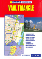
£9.99
The Rough Guide to Vintage London is your ultimate guide to London`s burgeoning vintage scene, that is making the British capital a more exciting place to visit than ever before. Whether you`re into fifties fashion or seventies furnishings, old-fashioned beauty parlours, Art Deco cafes or retro restaurants, The Rough Guide to Vintage London will show you where to find the best bargains & the hippest hang-outs. This authoritative illustrated guide casts a discerning eye over the entire city, highlighting the best of vintage London in each area. It covers over 200 budget & luxury attractions, from the East End hotspots of hyper-cool Hoxton & Shoreditch to the eccentric emporia of the West End, as well as the pick of London`s markets & the classiest vintage outlets north & south of the centre, all marked on full-colour maps. Whatever your look or interest
- blitz chic, beehive hairdo, forties screen idol, rockabilly, twenties flapper or Edwardian chap
- The Rough Guide to Vintage London will tell you where you can enjoy them to the full.

...
Archived Product
£14.99
These beautiful postcards have been selected from the bestselling V&A Pattern titles. Drawing on designs intended for textiles, wallpaper, fashion & furnishing, this richly varied collection is a resource for artists, designers & students, as well as a charming addition to the design fan`s stationery collection. Presented in a colourful presentation box, these beautifully printed patterns range from the intricate floral motifs of William Morris & C.F.A. Voysey to the wit & vibrancy of Pop era design; from the cool restraint of Fifties textile design to the iconic designs of Liberty & Co. A desirable gift & a surprising trove of design inspiration, this postcard collection is the perfect introduction to the V&A`s design collections. ...
Archived Product
£30.00
This attractive series reveals the V&A`s spectacular & extensive pattern collections. Each title in the series

Includes::


...
Archived Product
£3.99
Discover V-Mail
- the Roman empire's equivalent of the email or text message! The letters discovered at Vindolanda were written
...
Archived Product
£10.99
This is a unique notebook from Cavallini & Co. with a beautiful & robust cover featuring a vintage map of the world by V.C. Finch. It

Includes::
144 lined pages, an inside rear pocket & a handy elastic band to keep it tidy. This is an ideal travel companion to write notes, thoughts & plans.

...
Archived Product
£17.99
The 1:50, 000 topographic map gives a more general picture of the ground features than a basic map. It shows settlements, houses, roads, cultivated areas, waterways, cutting areas, mires, rock exposures, & relief. One map sheet covers an area of 30 x 40 km & one centimetre corresponds to 500 metres on the ground. The 1:50, 000 topographic map is also an ideal complement to nautical charts as it provides useful information about the land areas adjacent to waterways. For example, all Finnish sea areas are covered by 1:50, 000 topographic map sheets. ...
Archived Product
£17.99
The 1:50 000 topographic map gives a more general picture of the ground features than a basic map. It shows settlements, houses, roads, cultivated areas, waterways, cutting areas, mires, rock exposures, & relief. One map sheet covers an area of 30 x 40 km & one centimetre corresponds to 500 metres on the ground. The 1:50, 000 topographic map is also an ideal complement to nautical charts as it provides useful information about the land areas adjacent to waterways. For example, all Finnish sea areas are covered by 1:50 000 topographic map sheets. ...
Archived Product
£8.99
Have you ever: hitch-hiked? been skiing? been camping? travelled by train? been on a Weekend Break? been on a package holiday? been on a school exchange? been on a boating holiday? had a disastrous holiday? Then you should enjoy this book, Oliver Gray`s memoir of a lifetime spent travelling without style. ...
Archived Product
£35.00
This book celebrates the holiday home, traditionally a place of rest, relaxation & escape from the pressures of the 'real' world. Its many incarnations include beach shacks, mountain-top chalets, country estates, ranches & hobby farms, lakeside villas & isolated cabins. The unique styles reflect their owners' very personal approaches to what it means to be 'on vacation'. The architecture of holiday homes reveals the shift in lifestyle that defines a vacation; architects are required to work closely with their clients to achieve just the right spirit. The results of this collaboration can be breathtaking. ...
Archived Product

Vaal Triangle

A4 size, paperback street atlas of the municipal areas south of Johannesburg, between Walkerville LAC and Sasolburg, plus Heidelberg and Deneysville. Detail includes one-way streets, traffic lights, toll plazas, railways, airports, suburb and municipal boundaries, industrial areas, parks, and built-up areas. An extensive range of symbols shows tourist information offices, places of interest, hotels, shopping centres, post offices, various public buildings and community services, landmarks, cultural sites, recreation sites and nature reserves. Latitude and longitude values are stated for each corner of the 99 map pages, and on each page an arrow indicates the general direction to central Johannesburg.The map legend is in English only. The atlas is indexed not only for
streets but also suburbs, shopping centres, museums and various community services eg. emergency services, administrative offices, schools and hospitals.
RIP - This product is no longer available on our network. It was last seen on 25.09.2019

This page now acts as a permanent archive for this product. Add more information using the comments box below to ensure it can still be found by future generations.

Use our search facility to see if it is available from an alternative contributor.
  • External links may include paid for promotion
  • Availability: Out Of Stock
  • Supplier: Stanfords
  • SKU: 9781868095568
Availability: In Stock
£12.95

Product Description

A4 size, paperback street atlas of the municipal areas south of Johannesburg, between Walkerville LAC & Sasolburg, plus Heidelberg & Deneysville. Detail

Includes::
one-way streets, traffic lights, toll plazas, railways, airports, suburb & municipal boundaries, industrial areas, parks, & built-up areas. An extensive range of symbols shows tourist information offices, places of interest, hotels, shopping centres, post offices, various public buildings & community services, landmarks, cultural sites, recreation sites & nature reserves. Latitude & longitude values are stated for each corner of the 99 map pages, & on each page an arrow indicates the general direction to central Johannesburg. The map legend is in English only. The atlas is indexed not only for streets but also suburbs, shopping centres, museums & various community services eg. emergency services, administrative offices, schools & hospitals.

Reviews/Comments

Add New

Price History

Vouchers

No voucher codes found.
Do you know a voucher code for this product or supplier? Add it to Insights for others to use.

Facebook

Jargon Buster

Railways - A set of tracks that have been laid for the purpose of trains to travel up and down them
Size - is the measurement of how big an object is in space.

Supplier Information

Stanfords
Stanfords was established in 1853 and opened their iconic Covent Garden flagship store in 1901. They have become the top retailer of maps, travel books and accessories in the UK and arguably offer the largest selection of maps and travel books worldwide. Famous names such as Captain Robert Falcon Scott, Ranulph Fiennes and Michael Palin have purchased from Stanfords. They now have a shop in Bristol and both stores together with other venues operate a calendar of events including talks, book signings and exhibitions. As a specialist map retailer, the map selection is comprehensive and includes road maps, street maps and walking maps from worldwide destinations, as well as a selection of world atlases and wall maps. Books include travel guides and travel literature. Stanfords also stock globes, from miniatures made of blue marble to magnificent floor-standing globes. The website features a selection of interesting articles on travel topics.
Page Updated: 2023-11-12 20:15:36

Community Generated Product Tags

Oh No! The productWIKI community hasn't generated any tags for this product yet!
Menu