More From Contributor
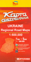
£44.99
Passage Charts C1 English Channel 1:1.750.000 C2 River Thames to Great Yarmouth 1: 375.000 Coastal Charts C3 Harwich Approach · Sunk Centre 1: 150.000 C4 Great Yarmouth to Felixstowe 1: 150.000 C5 Thames Estuary North 1: 75.000 C6 Harwich Approaches 1: 75.000 C7 Orford to Southwold 1: 75.000 C8 Southwold to Great Yarmouth 1: 75.000 C9 River Crouch Approach 1: 30.000 C10 Rivers Crouch & Roach 1: 30.000 C11 River Colne 1: 30.000 C12 River Blackwater 1: 30.000 C16 Harwich Deep Water Channel 1: 30.000 C18 Rivers Orwell & Stour 1: 30.000 C19 River Deben 1: 30.000 C20 Rivers Ore & Alde 1: 30.000 C22A Great Yarmouth Approach 1: 30.000 C22B Lowestoft Approach 1: 30.000 Details C13A Fambridge & Brandy Hole · R. Crouch 1: 12.000 C13B Burnham-on-Crouch · R. Crouch 1: 10.000 C13C Bridgemarsh Marina · R. Crouch 1: 10.000 C14 West Mersea Marinas · R. Blackwater 1: 12.000 C15A Brightlingsea · R. Colne 1: 8.000 C15B Maldon· R. Blackwater 1: 12.000 C15C Colchester · R. Colne 1: 15.000 C17 Walton Backwaters 1: 15.000 C19A Woodbridge · R. Deben 1: 12.000 C20A Southwold · R. Deben 1: 10.000 C21A Harwich 1: 10.000 C21B Suffolk Yachthbr. · R. Orwell 1: 10.000 C21B Woolverstone Marina · R. Orwell 1: 8.000 C21D Ipswich · R. Orwell 1: 12.000 C23A Lowestoft Harbour 1: 10.000 C23B Great Yarmouth Harbour 1: 10.000 Legend · General Notes C24 Tidal Stream Charts C25 Tide Tables · Tidal Stream Tables C26 ...
Archived Product
£6.95
Let Southbound take you to a place of wonder & beauty that sprawls in breathtaking splendour between the Kwa Zulu-Natal Midlands & the ice-capped peaks of the Kingdom of Lesotho. The Ama Zulu
- ' People of Heaven'
- who live in the long eastern shadow of the mountains call them u Khahlamba, the ' Barrier of spears'. The first Boer settlers to trail their ox-wagons into the foothills dubbed them the Drakensberg, the ' Dragon's mountain'. Both names are in official use today, but South Africans, in unconscious recognition of its singularity, tend simply to refer to the u Khahlamba-Drakensberg as The Berg
- ' The Mountain'. The Park
- 2, 500 square kilometres
- is the single largest mountain wilderness area protected anywhere in Africa. It is sacred to the ancients, the Bushmen, as depicted in the highest concentration of rock art in Africa. It is a historical melting pot of Bushmen, Xhosa, Sotho, Zulu, Boer & Brit. A wealth of fauna & flora with 2, 153 plant, 48 mammal & over 300 bird species are identified. This title

Includes::
detailed maps, colour photographs, hiking trails & route guides. It also

Includes::
comprehensive listings for travellers of places to go, things to see, & accommodation.


...
Archived Product
£9.50
Topographical survey of Belgium at 1:20, 000 from Nationaal Geografisch Instituut / Institut Géographique National, the country’s national survey organization. Each 20K map covers one quarter of the corresponding 1:50, 000 map (with adjustments in the border & coastal areas). The maps provide all the information expected of topographic mapping at this scale & in addition have an unusually large amount of vegetation and/or land use information (different types of woodlands, gardens, orchards, heath, etc). The maps have a 1-km UTM grid, with margin ticks for latitude & longitude at intervals of 1`. Map legend & a glossary of terms used on the maps include English. Stanfords keeps as regular stock 20K maps for the World War I battlefields around the Ypres, Messines & Passchendaele, & for the area of the Battle of Waterloo. The 1:20, 000 survey covers the whole of Belgium & maps for other regions can be supplied as special orders. To see the list of titles in this series please click on the series link.PLEASE NOTE: the Long-Distance Footpaths Map of Belgium at 1:300, 000 which shows the division of Belgium into the 50K survey sheets can also be used to see in more detail coverage by the 20K maps. ...
Archived Product
£19.95
Ukkusiksalik National Park in Nunavut at 1:375, 000 in a series of GPS compatible recreational maps at various scales from Go Trekkers highlighting recreational possibilities including trekking and/or snowshoe trails, canoeing & kayaking routes, campgrounds, warden stations, etc. Cartography of each title varies according to the terrain of the national park, but the maps are contoured & have spot heights plus, as appropriate, graphics to show wetlands, relief shading in mountainous areas, etc. All the titles are GPS compatible with either a UTM or latitude/longitude grid. Presentation of trails, recreational facilities such as campgrounds, access to the park by road or air, etc, also varies according to what each park has to offer & where it is situated. Each map also

Includes::
notes about the park.

...
Archived Product
£7.50
Double-sided road map of Ukraine, with all the place names shown only in the Roman alphabet. The map also shows railways &


...
Archived Product
£12.79
Ukraine in the Countries & Regions series from Lonely Planet, market-leading comprehensive guides aimed at independent travellers & serving a large range of international destinations. Frank & informal in style, the guides explore an extensive range of sights, activities, accommodation, restaurants & nightlife & are designed for practical use while travelling on the road. Written & researched by a team of experts, each book is independent in its recommendations & suggestions, often offering individual takes on individual destinations. Widely recognised for their reliability, each Lonely Planet country & region guide has the same layout. Introductory sections profile the destination with individual chapters on particular highlights, getting started, (including when to go) itineraries, history, culture, arts, food & drink & the environment. Each guide is organised geographically by region, with individual sections detailing an extensive range of sights, places of interest, attractions, restaurants, nightlife, accommodation & any local activities. The guides have detailed explanations of historical context where relevant. There is also practical guidance on ...
Archived Product
£11.99
The MARCO POLO map of Ukraine at 1:800, 000. The most beautiful places are highlighted with yellow or green markings so that you really do not miss anything on the way. Found a nice route? With the self-adhesive mark-it stickers in the envelope flap, the targeted route can be emphasized & thus easily rediscovered the next time you look at the map. ...
Archived Product
£14.99
Discover Ukraine
Feast your eyes on Scythian gold & mummified monks at Kyiv's Caves Monastery
Descend to the underground

...
Archived Product
£14.99
This fully updated guide will keep you up to speed with this rapidly evolving country. It features comprehensive practical information, while revealing the country's personality through in-depth exploration of its history, culture & natural beauty. Traditional churches, monasteries & sacred sites provide a contrast to the notorious, but compelling, landmark of Chernobyl. Andrew Evans shows how Ukraine can easily be explored by rail, river cruise or sea ferry, & also on foot
- the ideal way to take in rustic villages of old-world eastern Europe.
...
Archived Product
£7.50
Ukraine, Belorussia & Moldova at 1:2, 000, 000 from the Budapest based Catrographia on a useful overview road map providing coverage from Warsaw to Moscow & from St. Petersburg to the Crimea. Where appropriate all names of towns & villages are shown in both Cyrillic & Latin alphabets. Names of geographical features such as mountain ranges, peaks & passes are given only transliterated. The map shows the road network with driving distances indicated on main & secondary routes & locations of border crossings. Railway lines are included & local airports are marked. Small symbols highlight a few places of interest, but the map is not really designed to show tourist information. Latitude & longitude lines are drawn at intervals of 2°. The index on the reverse is arranged by country & lists only the transliterated versions. Also provided is a distance table. Map legend

Includes::
English.

...
Archived Product

Ukraine

Double-sided road map of Ukraine, with all the place names shown only in the Roman alphabet. The map also shows railways and includes small street plans of Kiev, Lviv, Odessa, Dnipropetrovsk, Donetsk and Kharkiv, a distance chart and an index of places. Map legend includes English.
RIP - This product is no longer available on our network. It was last seen on 25.09.2019

This page now acts as a permanent archive for this product. Add more information using the comments box below to ensure it can still be found by future generations.

Use our search facility to see if it is available from an alternative contributor.
  • External links may include paid for promotion
  • Availability: Out Of Stock
  • Supplier: Stanfords
  • SKU: 3282118604418
Availability: In Stock
£7.50

Product Description

Double-sided road map of Ukraine, with all the place names shown only in the Roman alphabet. The map also shows railways &

Includes::
small street plans of Kiev, Lviv, Odessa, Dnipropetrovsk, Donetsk & Kharkiv, a distance chart & an index of places. Map legend

Includes::
English.

Reviews/Comments

Add New

Price History

Vouchers

No voucher codes found.
Do you know a voucher code for this product or supplier? Add it to Insights for others to use.

Facebook

Jargon Buster

Railways - A set of tracks that have been laid for the purpose of trains to travel up and down them
Small - something that takes up less space than normal.
Road - a manmade lane or a path that is used to speed up travel.

Supplier Information

Stanfords
Stanfords was established in 1853 and opened their iconic Covent Garden flagship store in 1901. They have become the top retailer of maps, travel books and accessories in the UK and arguably offer the largest selection of maps and travel books worldwide. Famous names such as Captain Robert Falcon Scott, Ranulph Fiennes and Michael Palin have purchased from Stanfords. They now have a shop in Bristol and both stores together with other venues operate a calendar of events including talks, book signings and exhibitions. As a specialist map retailer, the map selection is comprehensive and includes road maps, street maps and walking maps from worldwide destinations, as well as a selection of world atlases and wall maps. Books include travel guides and travel literature. Stanfords also stock globes, from miniatures made of blue marble to magnificent floor-standing globes. The website features a selection of interesting articles on travel topics.
Page Updated: 2023-11-12 20:15:36

Community Generated Product Tags

Oh No! The productWIKI community hasn't generated any tags for this product yet!
Menu