More From Contributor
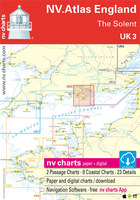
£6.99
UK Travellers to India Earthed Adaptor – 249
- converts UK three pin plugs to the Indian socket outlet system. Also suitable for
...
Archived Product
£7.99
This UK to South Africa Travel Adaptor enables you to use your electrical equipment in South Africa by converting your 3-pin UK plugs into a South African socket for instant use. * Please note
- this product is earthed & fully safety approved but does not convert voltage.*
...
Archived Product
£20.00
Compiled by experts of the Long Distance Walkers’ Association, Cicerone’s UK Trailwalker’s Handbook is a comprehensive directory of all recognised long-distance routes across Scotl&, Engl&, Wales, & Northern Irel&. Combining descriptions by region of hundreds of hundreds of waymarked trails, including 19 National Trails, & many hundreds more enthusiasts’ routes, the guide covers of 700 routes, more than 40, 000 trail miles. As with Cicerone’s other publications, it is full of full-colour photographs & overview maps, here with additional essays by members of the Long Distance Walkers’ Association. ...
Archived Product
£44.99
Passage Charts C1 English Channel 1: 1.750.000 C2 Isles of Scilly to Plymouth 1: 350.000 C3 Plymouth to Bournemouth 1: 350.000 Coastal Charts C4 Isles of Scilly to Land‘s End 1: 150.000 C5 Land‘s End to Lizard Pt. 1: 150.000 C6 Lizard Pt. to Plymouth 1: 150.000 C7 Plymouth to Brixham 1: 150.000 C8 Land‘s End to Lizard Pt. 1: 75.000 C9 Lizard Pt. to Veryan Bay 1: 75.000 C10 Veryan Bay to Looe Bay 1: 75.000 C11 Looe Bay to Bigbury Bay 1: 75.000 C12 Bigbury Bay to Dartmouth 1: 75.000 C13 Isles of Scilly 1: 40.000 C14 Approaches to St. Mary‘s 1: 25.000 Details C15A St. Mary‘s 1: 12.000 C15B Land‘s End 1: 15.000 C15C Hella Point · Runnel Stone 1: 15.000 C16A Penzance 1: 15.000 C16B Porthleven 1: 6.000 C16C Mullion Cove 1: 6.000 C16D Lizard Point 1: 20.000 C17A/B River Helford 1: 15.000 C18 Falmouth Estuary 1: 15.000 C19 Rivers Fal & Truro 1: 15.000 C19A Truro 1: 15.000 C20 Falmouth Harbour 1: 6.000 C20A Mylor 1: 6.000 C21 River Fowey South 1: 10.000 C22A River Fowey North 1: 18.000 C22B Mevagissey 1: 6.000 C22C Looe 1: 15.000 C23 Plymouth Sound 1: 15.000 C24 Plymouth · Hamoaze 1: 15.000 C25A/B Plymouth Harbours 1: 6.000 C26 River Yealm 1: 15.000 C27 Salcombe 1: 15.000 C28 Lgend · General Notes C29 Tidal Stream Charts C30 Tide Tables · Tidal Stream Tables ...
Archived Product
£44.99
Passage Charts C1 English Channel 1: 1.750.000 C2 Plymouth to Bournemouth 1: 350.000 Coastal Charts C3 Start Point to Portland Bill 1: 150.000 C4 Portland Bill to The Needles 1: 150.000 C5 Dartmouth to Exmouth 1: 75.000 C6 Portland Bill to Anvil Pt. 1: 75.000 C7 Anvil Point to The Needles 1: 75.000 Details C8 Dartmouth 1: 15.000 C9 River Dart 1: 15.000 C9A Totnes 1: 15.000 C9B Dartmouth Detail 1: 6.000 C10A Tor Bay 1: 25.000 C10B Brixham 1: 6.000 C10C Torquay 1: 6.000 C11 River Exe 1: 20.000 C11A Exeter 1: 20.000 C11B Exmouth 1: 6.000 C12A Teignmouth 1: 8.000 C12B Lyme Regis 1: 8.000 C12C Bridport Hbr. 1: 8.000 C12D Worbarrow Bay 1: 12.000 C12E Lulworth Cove 1: 5.000 C12F Chapman‘s Pool 1: 10.000 C13A Portland Harbour 1: 15.000 C13B Weymouth Harbour 1: 8.000 C14A Swanage Bay 1: 20.000 C14B Christchurch 1: 15.000 C15 Poole Harbour East 1: 20.000 C16 Poole Harbour West 1: 20.000 C17A Poole 1: 8.000 C17B Bournemouth 1: 6.000 C18 Legend · General Notes C19 Tidal Stream Charts C20 Tide Tables · Tidal Stream Tables ...
Archived Product
£44.99
Passage Charts C1 English Channel 1: 1.750.000 C2 Portland Bill to Eastbourne 1: 350.000 C3 Eastbourne to River Thames 1: 350.000 Coastal Charts C4 Portsmouth to Newhaven 1: 150.000 C5 Newhaven to Dungeness 1: 150.000 C6 Strait of Dover · Dungeness to Dover 1: 150.000 C7 Dover to River Thames 1: 150.000 C8 Selsey Bill to Shoreham-by-Sea 1: 75.000 C9 Shoreham-by-Sea to Beachy Head 1: 75.000 C10 Beachy Head to Hastings 1: 75.000 C11 Hastings to Dungeness 1: 75.000 C12 Dungeness to Dover 1: 75.000 C13 Dover to Margate 1: 75.000 C14 Thames Estuary · South 1: 75.000 C15 Thames Estuary · Sea Reach 1: 75.000 C18 Isle of Thanet 1: 30.000 C20 The Swale 1: 30.000 C22 River Medway West 1: 30.000 C23A River Medway West 1: 30.000 C24 River Thames Approach 1: 30.000 C25 River Thames · Canvey I. to Tilbury 1: 30.000 C26A/B River Thames · Tilbury to London 1: 30.000 Details C16A Littlehampton 1: 10.000 C16B Shoreham-by-Sea 1: 10.000 C16C Brighton Marina 1: 8.000 C17A Newhaven 1: 8.000 C17B Eastbourne 1: 12.000 C17C Rye 1: 18.000 C17D Folkestone 1: 12.000 C19A Dover 1: 10.000 C19B Ramsgate 1: 8.000 C22B Chatham · Gillingham & Hoo Marinas 1: 10.000 C23A The Swale West 1: 15.000 C23B Conyer 1: 10.000 Legend · General Notes · Limited Warranty C27 nv charts overview C28 Tidal Stream Charts C29 Tide Tables C30 ...
Archived Product
£44.99
Passage Charts C1 English Channel 1:1.750.000 C2 River Thames to Great Yarmouth 1: 375.000 Coastal Charts C3 Harwich Approach · Sunk Centre 1: 150.000 C4 Great Yarmouth to Felixstowe 1: 150.000 C5 Thames Estuary North 1: 75.000 C6 Harwich Approaches 1: 75.000 C7 Orford to Southwold 1: 75.000 C8 Southwold to Great Yarmouth 1: 75.000 C9 River Crouch Approach 1: 30.000 C10 Rivers Crouch & Roach 1: 30.000 C11 River Colne 1: 30.000 C12 River Blackwater 1: 30.000 C16 Harwich Deep Water Channel 1: 30.000 C18 Rivers Orwell & Stour 1: 30.000 C19 River Deben 1: 30.000 C20 Rivers Ore & Alde 1: 30.000 C22A Great Yarmouth Approach 1: 30.000 C22B Lowestoft Approach 1: 30.000 Details C13A Fambridge & Brandy Hole · R. Crouch 1: 12.000 C13B Burnham-on-Crouch · R. Crouch 1: 10.000 C13C Bridgemarsh Marina · R. Crouch 1: 10.000 C14 West Mersea Marinas · R. Blackwater 1: 12.000 C15A Brightlingsea · R. Colne 1: 8.000 C15B Maldon· R. Blackwater 1: 12.000 C15C Colchester · R. Colne 1: 15.000 C17 Walton Backwaters 1: 15.000 C19A Woodbridge · R. Deben 1: 12.000 C20A Southwold · R. Deben 1: 10.000 C21A Harwich 1: 10.000 C21B Suffolk Yachthbr. · R. Orwell 1: 10.000 C21B Woolverstone Marina · R. Orwell 1: 8.000 C21D Ipswich · R. Orwell 1: 12.000 C23A Lowestoft Harbour 1: 10.000 C23B Great Yarmouth Harbour 1: 10.000 Legend · General Notes C24 Tidal Stream Charts C25 Tide Tables · Tidal Stream Tables C26 ...
Archived Product
£6.95
Let Southbound take you to a place of wonder & beauty that sprawls in breathtaking splendour between the Kwa Zulu-Natal Midlands & the ice-capped peaks of the Kingdom of Lesotho. The Ama Zulu
- ' People of Heaven'
- who live in the long eastern shadow of the mountains call them u Khahlamba, the ' Barrier of spears'. The first Boer settlers to trail their ox-wagons into the foothills dubbed them the Drakensberg, the ' Dragon's mountain'. Both names are in official use today, but South Africans, in unconscious recognition of its singularity, tend simply to refer to the u Khahlamba-Drakensberg as The Berg
- ' The Mountain'. The Park
- 2, 500 square kilometres
- is the single largest mountain wilderness area protected anywhere in Africa. It is sacred to the ancients, the Bushmen, as depicted in the highest concentration of rock art in Africa. It is a historical melting pot of Bushmen, Xhosa, Sotho, Zulu, Boer & Brit. A wealth of fauna & flora with 2, 153 plant, 48 mammal & over 300 bird species are identified. This title

Includes::
detailed maps, colour photographs, hiking trails & route guides. It also

Includes::
comprehensive listings for travellers of places to go, things to see, & accommodation.


...
Archived Product
£9.50
Topographical survey of Belgium at 1:20, 000 from Nationaal Geografisch Instituut / Institut Géographique National, the country’s national survey organization. Each 20K map covers one quarter of the corresponding 1:50, 000 map (with adjustments in the border & coastal areas). The maps provide all the information expected of topographic mapping at this scale & in addition have an unusually large amount of vegetation and/or land use information (different types of woodlands, gardens, orchards, heath, etc). The maps have a 1-km UTM grid, with margin ticks for latitude & longitude at intervals of 1`. Map legend & a glossary of terms used on the maps include English. Stanfords keeps as regular stock 20K maps for the World War I battlefields around the Ypres, Messines & Passchendaele, & for the area of the Battle of Waterloo. The 1:20, 000 survey covers the whole of Belgium & maps for other regions can be supplied as special orders. To see the list of titles in this series please click on the series link.PLEASE NOTE: the Long-Distance Footpaths Map of Belgium at 1:300, 000 which shows the division of Belgium into the 50K survey sheets can also be used to see in more detail coverage by the 20K maps. ...
Archived Product
£19.95
Ukkusiksalik National Park in Nunavut at 1:375, 000 in a series of GPS compatible recreational maps at various scales from Go Trekkers highlighting recreational possibilities including trekking and/or snowshoe trails, canoeing & kayaking routes, campgrounds, warden stations, etc. Cartography of each title varies according to the terrain of the national park, but the maps are contoured & have spot heights plus, as appropriate, graphics to show wetlands, relief shading in mountainous areas, etc. All the titles are GPS compatible with either a UTM or latitude/longitude grid. Presentation of trails, recreational facilities such as campgrounds, access to the park by road or air, etc, also varies according to what each park has to offer & where it is situated. Each map also

Includes::
notes about the park.

...
Archived Product

UK3 The Solent

Passage ChartsC1 English Channel 1: 1.750.000 C2 Portland Bill to Beachy Head 1: 350.000 Coastal ChartsC3 Anvil Pt. to Selsey Bill 1: 150.000 C4 Western Approach of the Solent 1: 75.000 C5 Eastern Approach of the Solent 1: 75.000 C6 The Needles 1: 30.000 C7 The Solent · Western Part 1: 30.000 C8 The Solent · Middle Part 1: 30.000 C9 Southampton Water 1: 30.000 C10 The Solent · Eastern Part 1: 30.000 DetailsC11 Portsmouth Harbour 1: 20.000 C12A Langstone Harbour 1: 20.000 C12B Chichester Harbour Approach 1: 20.000 C13 Chichester Harbour 1: 20.000 C14A Keyhaven 1: 8.000 C14B Lymington 1: 12.000 C14C Yarmouth 1: 6.000 C15A Newtown River 1: 12.000 C15B/C River Medina 1: 12.000 C16A/B Beaulieu River 1: 12.000 C17A/B River Hamble 1: 8.000 C18 River Itchen 1: 10.000 C19A Cowes 1: 6.000 C19B
Gosport 1: 8.000 C20A Wootton Creek 1: 10.000 C20B Ryde 1: 6.000 C20C Port Solent 1: 8.000 C20D Bembridge Harbour 1: 10.000 C20E Southsea Marina 1: 10.000 C21A Northney Marina 1: 8.000 C21B Sparkes Marina 1: 8.000 C21C Chichester Marina 1: 8.000 Legend · General Notes C22 Tidal Stream Charts C23 Tide Tables · Tidal Stream Tables C24
RIP - This product is no longer available on our network. It was last seen on 25.09.2019

This page now acts as a permanent archive for this product. Add more information using the comments box below to ensure it can still be found by future generations.

Use our search facility to see if it is available from an alternative contributor.
  • External links may include paid for promotion
  • Availability: Out Of Stock
  • Supplier: Stanfords
  • SKU: 9783945902189
Availability: In Stock
£44.99

Product Description

Passage Charts C1 English Channel 1: 1.750.000 C2 Portland Bill to Beachy Head 1: 350.000 Coastal Charts C3 Anvil Pt. to Selsey Bill 1: 150.000 C4 Western Approach of the Solent 1: 75.000 C5 Eastern Approach of the Solent 1: 75.000 C6 The Needles 1: 30.000 C7 The Solent · Western Part 1: 30.000 C8 The Solent · Middle Part 1: 30.000 C9 Southampton Water 1: 30.000 C10 The Solent · Eastern Part 1: 30.000 Details C11 Portsmouth Harbour 1: 20.000 C12A Langstone Harbour 1: 20.000 C12B Chichester Harbour Approach 1: 20.000 C13 Chichester Harbour 1: 20.000 C14A Keyhaven 1: 8.000 C14B Lymington 1: 12.000 C14C Yarmouth 1: 6.000 C15A Newtown River 1: 12.000 C15B/C River Medina 1: 12.000 C16A/B Beaulieu River 1: 12.000 C17A/B River Hamble 1: 8.000 C18 River Itchen 1: 10.000 C19A Cowes 1: 6.000 C19B Gosport 1: 8.000 C20A Wootton Creek 1: 10.000 C20B Ryde 1: 6.000 C20C Port Solent 1: 8.000 C20D Bembridge Harbour 1: 10.000 C20E Southsea Marina 1: 10.000 C21A Northney Marina 1: 8.000 C21B Sparkes Marina 1: 8.000 C21C Chichester Marina 1: 8.000 Legend · General Notes C22 Tidal Stream Charts C23 Tide Tables · Tidal Stream Tables C24

Reviews/Comments

Add New

Intelligent Comparison

Oooops!
We couldn't find anything!
Perhaps this product's unique.... Or perhaps we are still looking for comparisons!
Click to bump this page and we'll hurry up.

Price History

Vouchers

No voucher codes found.
Do you know a voucher code for this product or supplier? Add it to Insights for others to use.

Facebook

Jargon Buster

water - A chemical substance. Chemical formula H2O.
Head - The upper part of a body typically separated by the neck.

Supplier Information

Stanfords
Stanfords was established in 1853 and opened their iconic Covent Garden flagship store in 1901. They have become the top retailer of maps, travel books and accessories in the UK and arguably offer the largest selection of maps and travel books worldwide. Famous names such as Captain Robert Falcon Scott, Ranulph Fiennes and Michael Palin have purchased from Stanfords. They now have a shop in Bristol and both stores together with other venues operate a calendar of events including talks, book signings and exhibitions. As a specialist map retailer, the map selection is comprehensive and includes road maps, street maps and walking maps from worldwide destinations, as well as a selection of world atlases and wall maps. Books include travel guides and travel literature. Stanfords also stock globes, from miniatures made of blue marble to magnificent floor-standing globes. The website features a selection of interesting articles on travel topics.
Page Updated: 2023-11-12 20:15:36

Community Generated Product Tags

Oh No! The productWIKI community hasn't generated any tags for this product yet!
Menu