More From Contributor

£17.99
Kadaster, Holland`s national survey organization, produces one of the most attractive topographic surveys in Europe. The maps are very colourful, with their characteristic patchwork of polders & an unusually large amount of land use information: meadows, arable l&, different types of forest, marshes, sand dunes, etc. Contours are shown at 5-metre intervals with numerous spot heights &, with such a large part of the country below the sea level, ”spot depths”. Each map covers an area of Approx. 25 x 20 km / 15 x 12 miles, with some sheets slightly larger. The maps have a 1-km Dutch national grid, plus latitude & longitude at intervals of 1`. Map legend

Includes::
English.IMPORTANT
- PLEASE NOTE BEFORE ORDERING: both the west (W) & the east (O) sheet of each number has the same name, although the town after which the two maps are named appears only on one of the sheets. For example: maps 41W & 41O are both called Arnhem, although the city of Arnhem appears only on sheet 40W, etc. To see the list of titles available in this series please click on the series link.


...
Archived Product
£6.99
The UK & European Travellers to India Earthed Adaptor – 249
- converts UK & European, American, Australian & Far East two & three
...
Archived Product
£29.99
Go Travel’s Worldwide Travel Adaptor will connect you to the electricity supply in over 150 countries. Simply plug your appliance in to the adaptor, press & slide the button on the side of the adaptor to adjust the pins you require, & then plug yourself in. Please note
- the adaptor does not convert voltage. Use only up to 2.5A/250V for non-earthed appliances.
...
Archived Product
£19.99
” The new circumnavigation bible”
- Geoff Holt (the first disabled sailor to sail around Britain singlehandedly) A circumnavigation
...
Archived Product
£15.99
The UK & Ireland Map is a basic wall map of the British Isles, covered in a scratch-off silver top layer, designed for you to scratch off places as & when you’ve visited them. As you travel, make the UK map appear beneath your finger-tips. The mapping is revealed in full-colour & with geographic detail such as capital & major cities. The panels on the right list the counties & a few boxed notes at the bottom of the map explain the meaning & origin of a handful of ‘quintessential’ food & dialect expressions like ‘inky pinky’ or ‘council juice’! This map is presented in a protective tube & is recommended as a novelty item & fun gift. ...
Archived Product
£19.99
This is an exciting new diving guide covering dive sites in Engl&, Irel&, Scotland & Wales. Explore the wreck of the E39 submarine off Pembrokeshire or the stunning Cathedral Rock off St Abbs to the Unknown Coaster in Portland Harbour. In this title, 100 dives are described in detail from easy shore dives to more demanding boat dives. Dive locations are fully illustrated with specially commissioned maps & diagrams together with full colour photography throughout. All dives are above 18m & suitable for all levels of experience from novice to technical diver. The United Kingdom has some of the best diving available in Europe offering a mixture of scenic reef dives & spectacular wrecks. Wherever you are in the United Kingdom you are only a short distance away from one of these spectacular dives. ...
Archived Product
£7.99
Collins UK in Maps is a multi-topic atlas of the UK, which introduces the most relevant topics to reflect the Geography Key Stage 2-3 requirements of the National Curriculum. Formerly published as Collins Keystart UK Atlas, this collection of maps can be used to investigate different themes & topics. It tells a story in maps, diagrams, charts, words & photographs each of which presents information to compare & examine. We live on a remarkable planet & this atlas helps us to make sense of the UK today & understand how things came to be as well as how they might change in years to come. Suggested activities on each spread encourage users to explorer further. ...
Archived Product
£7.99
Overcome with patriotic fervour, New Zealander Justin Brown bets an Australian mate that the All Blacks will thrash the Wallabies in an up-coming match. They don't. Forced to pay his debt, Justin has to busk his way around England until he earns enough money for his airfare home. Armed with a black duffel coat & a guitar he travels the country in mid-winter, knocking on doors & singing for his supper. Along the way he meets gypsies, drinks with Britains most famous busker, harasses carol singers, plucks turkeys, speaks to J.K. Rowling & gets told to sod off 357 times. ...
Archived Product
£60.00
Fully illustrated in colour throughout, this comprehensive manual compiled by the UK P&I Club details best practice for the carriage, loading & storage requirements for a wide range of cargoes. It also contains essential information on draught surveys, preparing cargo plans & the stowage of general & deck cargoes. ...
Archived Product
£15.00
Published by TSO with permission from Network Rail (owners of Britain's national railway & stations), the GB Rail Timetable
-
...
Archived Product

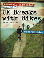
UK Breaks With Bikes

This (A5 size) guidebook to Mountain bike breaks around the United Kingdom has over 100 top rides around the country, specifically in the UK holiday hot spots, as well as the riding hot spots, so you can ride the best trails around whether you use the book to plan a cycling specific trip or you just happen to be in the area and want to do some riding. The routes are presented on water resistant, removable pages, made with Ordnance Survey mapping and with extension and shortcut options. Rough Ride Guides have also included plenty of family friendly riding and options, as well as information on the man-made trail centres and even some suggested road trips.
RIP - This product is no longer available on our network. It was last seen on 25.09.2019

This page now acts as a permanent archive for this product. Add more information using the comments box below to ensure it can still be found by future generations.

Use our search facility to see if it is available from an alternative contributor.
  • External links may include paid for promotion
  • Availability: Out Of Stock
  • Supplier: Stanfords
  • SKU: 9780954882921
Availability: In Stock
£24.95

Product Description

This (A5 size) guidebook to Mountain bike breaks around the United Kingdom has over 100 top rides around the country, specifically in the UK holiday hot spots, as well as the riding hot spots, so you can ride the best trails around whether you use the book to plan a cycling specific trip or you just happen to be in the area & want to do some riding. The routes are presented on water resistant, removable pages, made with Ordnance Survey mapping & with extension & shortcut options. Rough Ride Guides have also included plenty of family friendly riding & options, as well as information on the man-made trail centres & even some suggested road trips.

Reviews/Comments

Add New

Intelligent Comparison

Oooops!
We couldn't find anything!
Perhaps this product's unique.... Or perhaps we are still looking for comparisons!
Click to bump this page and we'll hurry up.

Price History

Vouchers

No voucher codes found.
Do you know a voucher code for this product or supplier? Add it to Insights for others to use.

Facebook

Jargon Buster

UK - United Kingdom - An island nation in Europe
Water Resistant - A mark to indicate how well an item, usualy a watch, resists water ingress
water - A chemical substance. Chemical formula H2O.
hot - An indication of the temperature being high and a sensation of heat to the tough
Size - is the measurement of how big an object is in space.
Road - a manmade lane or a path that is used to speed up travel.
Resistant - Something that can repel against something.
Extension - Something that is made bigger through adding to it, for example a conservatory extension on a house.
Family - A group of people that live together made up from parents and children.

Supplier Information

Stanfords
Stanfords was established in 1853 and opened their iconic Covent Garden flagship store in 1901. They have become the top retailer of maps, travel books and accessories in the UK and arguably offer the largest selection of maps and travel books worldwide. Famous names such as Captain Robert Falcon Scott, Ranulph Fiennes and Michael Palin have purchased from Stanfords. They now have a shop in Bristol and both stores together with other venues operate a calendar of events including talks, book signings and exhibitions. As a specialist map retailer, the map selection is comprehensive and includes road maps, street maps and walking maps from worldwide destinations, as well as a selection of world atlases and wall maps. Books include travel guides and travel literature. Stanfords also stock globes, from miniatures made of blue marble to magnificent floor-standing globes. The website features a selection of interesting articles on travel topics.
Page Updated: 2023-11-12 20:15:36

Community Generated Product Tags

Oh No! The productWIKI community hasn't generated any tags for this product yet!
Menu